Man, this radome testing is getting complicated. I had kinda presumed that the Navico Broadband BR24 would be obviously superior to other 18" scanners. But, as discussed recently, the Raymarine RD418D kinda torpedoed that presumption. While I doubt that any radar can target a moving dinghy and two sailboats on a float at 100 feet as cleanly as you see above, there is a lot more to radar than super near range. The inflatable, incidentally, dissappeared when it got nearly alongside, but that situation may change when I move the BR dome down to flying bridge level. And then I'll also have two radar mounts available for testing 18" scanners from Garmin and Furuno...
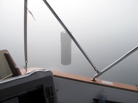
"The fog was so thick that..." is a popular line here on the coast of Maine, especially this summer. Well, it was so foggy yesterday morning that we didn't actually see this can buoy until it was just a little over a boat length ahead, and, yes, as the photo suggests, it was so glassy gray calm that fog and Bay blended into blank oneness. But the amazing thing, I thought, was that the new Raymarine Digital 18" radome I'm testing captured this can about 3/4's of a mile away and held it tight and clear almost right to that boat length visibility distance. These are great days for real radar testing...
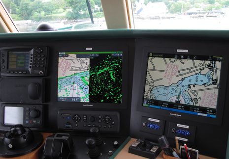
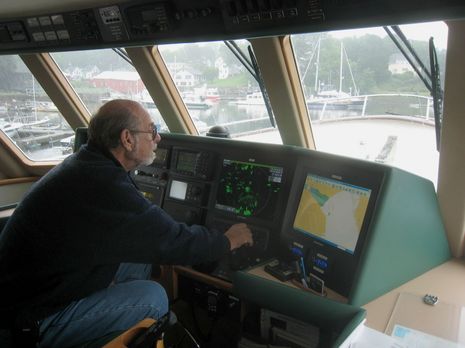
Well, that was exciting. Yesterday afternoon I went out on the Bay aboard Spirit of Zopolite, in large part so Capt. Bruce Kessler could show me how well his new Furuno 4-foot UHD radar works in close quarters now that he's seen Navico's Broadband Radar. And he was right; once away from the dock, the NavNet3D screen was resolving the complications of Camden Harbor very well indeed. The photo above, worth examining large (click on it), shows us returning via the channel through the Outer Harbor moorings, with almost all the boats and shoreline sharply resolved at quarter mile scale, and we could have gone down to 1/8th mile. I've been in this spot many times when you couldn't see anything except an occasional channel bouy or vague boat shadow, and it's interesting to compare the image with BR24 screens taken a few weeks ago...
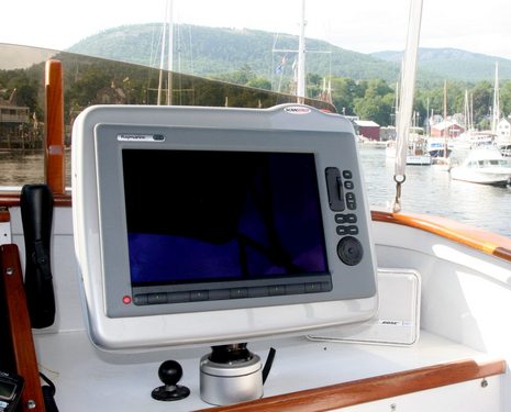
Yes, I'm frustrated that a combination of weather, travel, and gizmo glitches has so far prevented me from getting this Raymarine C140W and the attached RD418D Digital Radar operational, and then comparing it with Navico Broadband Radar (and Garmin HD radomes, too), but it was educational to install the MFD in that new Scanstrut Deck Pod. The completed rig is quite slick: the "silver" finish goes nicely with Ray gray, I think; all the cables pass easily, and invisibly, through the base; and the whole pod angle adjusts smoothly but locks up solid with that lever (which, after a little tweaking, now goes tight against the base when locked). But putting it altogether was a little challenging...
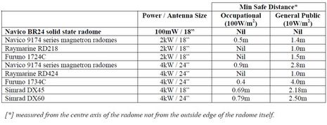
Since we're already discussing the Navico BR24, let's take a look at an interesting disagreement that's cropped up regarding its safety claims. At introduction, Navico's CEO called this low wattage solid state technology "a huggable radar" -- i.e. without any radiation danger whatsoever. But how dangerous are conventional magnetron marine radars in this size range? In the July issue of PMY, the new electronics editor Tim Bartlett tries to answer that question, and concludes, "So rest easy. While your microwave oven could theoretically cook you, a
small radar can't because it doesn't transmit long enough or with
enough power." Navico disagrees...
The weather here -- a phenomenal run of rain and fog -- has been great for testing the Broadband Radar temporarily installed on Li'l Gizmo, and I promise a screenshot show soon. But I've realized that while I've used many radars, and seen many others demonstrated, I've never had one on my own boat, and thus am not dead sure that the performance I'm seeing is as amazing as it seems. How convenient, then, that the indomitable Spirit of Zapolite cruised in out of the murk on Monday, complete with a brand new Furuno NavNet 3D system swinging a 4' Ultra High Definition array. That's the indomitable Capt. Kessler above, trying to tune NN3D/UHD to get as crisp and detailed an image of Camden Inner Harbor as he'd just seen on a 14-foot outboard!
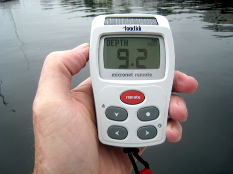
Mission accomplished! I tried integrating a Tacktick wireless sensor and display network with a NMEA 2000 sensor and display network, and the results were quite good. The depth seen on the remote above is coming from a Maretron DST100 in Gizmo's bottom. The Micronet system is also getting Heading, Speed through Water, COG/SOG, and more from the N2K system, which it can display and/or use for True Wind calculations. Meanwhile -- and perhaps coolest of all -- all displays on the N2K backbone are getting Apparent Wind info from the wireless Tacktick wind vane I simply clamped to Gizmo's mast...
Thanks to Rich Owings, who runs the excellent GPSTracklog site, we now know that Garmin will soon introduce four new open array radars. The photo above comes from deep within the FCC equipment authorization database (sorry, linkage not possible), where anyone as patient as Rich might have discovered that four new Garmin radars were granted approval on Friday. The model designations are GMR 604, 606, 1204, and 1206 -- which strongly suggest that they range from a 6 kW 4 foot array to a 12 kW 6 foot unit (hello, big yachts and sport fishermen) -- and which will probably be sold in two parts like Garmin's existing open arrays. But what the heck is "xHD"...?...
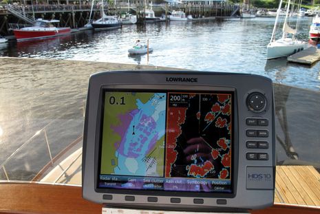
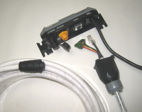
Navico Broadband Radar is apparently meeting its promised "Q2" shipping schedule, and I'm already impressed with the install details. Above you can see how a waterproof gland fits over the scanner cable -- which is just a bundle of Ethernet and power wires -- before it's screwed to the interface box. If the ultimate destination is a Simrad NX or a Northstar 8000i, you then run a proprietary serial cable to the 'comms' port, while Lowrance HDS units use a proprietary Ethernet cable to that orangey 'network' port. It all went together quickly and feels solid...
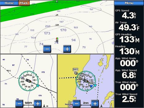
This entry's title is not about cause and effect; my wind sensor testing may go incomplete, but that has nothing to do with Garmin's chart problem. And while I had a good time on the water yesterday, even if frustrated by details, the mood in Kansas seemed a bit morose. Imagine the satisfaction of introducing all the free and amazing enhancements in Garmin's 5.0 marine software (which I was enjoying immensely, as seen above), but then just a few weeks later realizing that there was a processing error in the creation of new and improved Bluecharts that was potentially so bad that you had to recall all the 2009 chart cards sold so far around the world. Ouch!