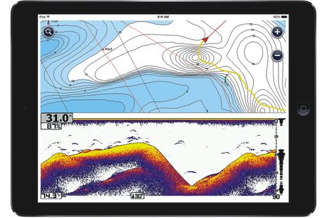
Wow. Combining the Navionics Boating apps and the Vexilar SonarPhone WiFi fishfinder seems like an obvious development now, but there are so many marine electronics integration possibilities these days that even the ripe low-hanging fruit can be surprising. Announced yesterday at ICAST (PDF here) and available for iPhone/iPad in August (and Android later), the combined Navionics SonarPhone app means that a small boater can have a fairly sophisticated plotter/fishfinder for about $200, phone or tablet not included (and note the issue of screen visibility in an open boat). I was impressed with the SonarPhone bobber-style T-Pod in April and suspect that SP200 T-Box small boat model works even better. And there's more: the users of this system can very easily contribute their sonar logs to Navionics' SonarChart collection, which they can access (along with chart updates) with an additional $25 Navionics+ annual subscription.
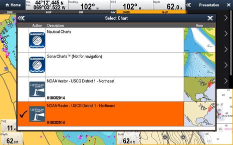
This is a significant surprise. Version 7.0 of the free Navionics Boating app released today for iPad and iPhone includes the ability to download and use NOAA vector charts, as seen above. Meanwhile, if you already own a Navionics Marine app for iOS, there's a 7.0 update available which adds "Gov Charts" and the same feature will soon come to Android versions of both the Boating and Marine apps. Navigators who already use Navionics charts on a tablet or phone may find it useful to have NOAA data for comparison, but the big news is that any U.S. boater can now enjoy a Navionics level charting app completely free...
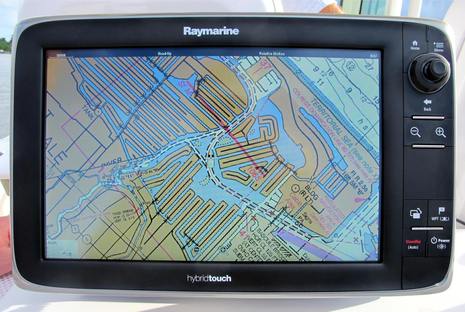
A demo look at the new LightHouse Charts got me excited last fall, and I feel more so now that I've cruised around with them. U.S. boaters who own Raymarine a-, c-, e-, or gS-Series multifunction displays will find that both types of reprocessed free NOAA charts install fairly easily, look good and zoom/pan quickly. And though no LightHouse charts for waters beyond the U.S. have been announced, Raymarine clearly has the ability to produce them or permit third party cartographers like NV-Charts to do it themselves. Finally, Raymarine's U.S. plotter models should hopefully cost a little less with free charts, and Navionics has perhaps been motivated to up its game. (Whatever the motivation, significant new Navionics features are right around the corner.)
Isn't it interesting that just after we learned that NOAA will no longer print traditional paper charts, Raymarine announced that all its current plotters will soon be able to use the digitized "raster" equivalent of those same NOAA charts? The "completely redesigned LightHouse II" software that will make this entirely free new feature happen is due out in December, but I got on the water with a beta version last week. I was impressed with how well the raster charts looked and how well they panned and zoomed, even in beta, and there's much more to like about LightHouse II...
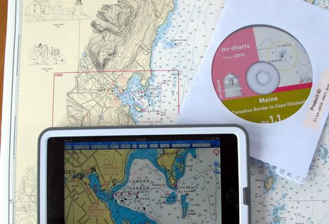
NOAA's Office of Coast Survey has been making news. We were just discussing changes to the Magenta Line on ICW charts when a reader (thanks, Collin) caught the announcement that OCS will stop printing traditional paper charts next April, which even got on NPR national radio. Charts lithographically printed on heavy paper are a beautiful technology and it hurts a bit to see them go, but I'm not sure it makes much practical difference. Personally, I haven't purchased one in a long time (nor do I ever throw them away) and I guess the mandatory carriage commercial vessels will do fine with print-on-demand charts and/or slowly proliferating ECDIS systems. At any rate, it seems like a good time to discuss how nicely the NV-Charts paper/digital package has evolved and also, the new ways that NOAA is distributing its cartography...
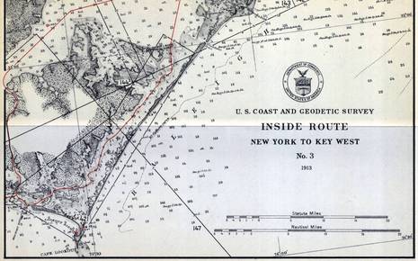
When Peter Swanson called to say he'd just become PassageMaker's new editor-in-chief (which he'll be great at, I think), the conversation soon turned to our strong mutual interests in cruising, electronics and charts. That's how I finally learned that NOAA has started to remove the magenta chart lines that guide many users of the Intracoastal Waterway (ICW) and that they may never be replaced. Peter wrote about the issue in August, and NOAA recently put up a notably well-crafted Federal Register article that seeks more comments from the public. That's where I learned that the brightly colored "recommended route lines" began on a 1913 chart series called the Inside Route Pilot -- fascinating sample above, full size here -- and that the lines haven't been comprehensively updated since the 1930's, when taxpayers spent a lot of money expanding the ICW (and creating jobs)...
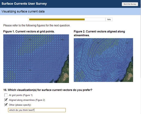
Maybe you, too, have an opinion about how predicted currents should be overlaid on electronic charts? Well, the International Hydrographic Organization (IHO) is developing an S-100 specification for "the delivery and presentation of navigationally significant surface currents" and right now they're running an online survey of all interested parties. What waters do you care about (coastal for me)? What prediction frequency would you like? Are you willing to pay? How should the data look? And more...
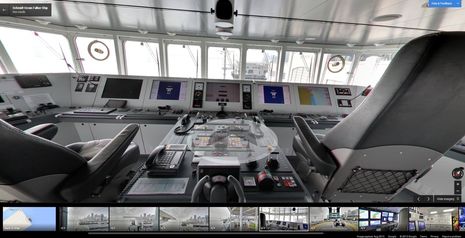
I was blown away, partially due to the timing. Just after writing about how apps can make fascinating historical cartography easily accessible, I learned about a fascinating advance in 21st century mapping. I'd guess that most every Panbo reader has marveled at the seamless panoramic photography found in Google Street Maps; well, now it's possible to use very similar technology to tour inside a ship, and the vessel Google chose for the first demonstration is a corker...
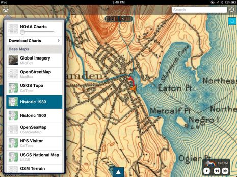
I was testing the new marine navigation app Skipper when I realized that historical topos were among the many "base maps" it can display, along with regular NOAA raster charts. Skipper has some interesting features (to be covered soon), but I've been waiting a long time for this historical angle. Haven't marine electronics and software become so powerful that they can help us with more than just the "work" of operating a boat? As in my hopeful 2005 comment that, "One day PC/plotter memory will be so abundant that historical charts will be included in navigation packages just for the fun of it!" Of course, I didn't realize then that tablet computers with wireless broadband Internet connections would come along, and aren't they dandy for accessing the ever growing cloud of cartography?
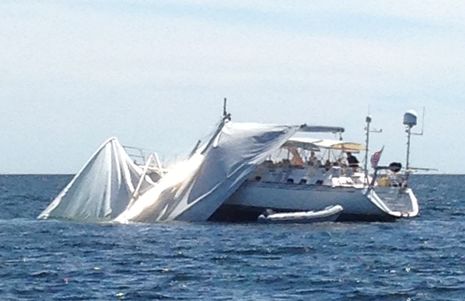
While my friend Leonard Lookner was first to come upon this distressing scene Wednesday afternoon, he too was sailing and thus, a powerboat just behind him was first to offer assistance. But it was Leonard's iPhone photos that fueled a local PenBay Pilot news piece, which then prompted an interesting SailNet discussion. Of course, it was suggested that marine electronics or digital charts were somehow to blame - allegations I'd like to refute, and I also want to report on how well this worse-than-it-even-looks situation actually turned out. Plus, getting reminded to be careful out there is never a bad idea...

 Wow. Combining the Navionics Boating apps and the Vexilar SonarPhone WiFi fishfinder seems like an obvious development now, but there are so many marine electronics integration possibilities these days that even the ripe low-hanging fruit can be surprising. Announced yesterday at ICAST (PDF here) and available for iPhone/iPad in August (and Android later), the combined Navionics SonarPhone app means that a small boater can have a fairly sophisticated plotter/fishfinder for about $200, phone or tablet not included (and note the issue of screen visibility in an open boat). I was impressed with the SonarPhone bobber-style T-Pod in April and suspect that SP200 T-Box small boat model works even better. And there's more: the users of this system can very easily contribute their sonar logs to Navionics' SonarChart collection, which they can access (along with chart updates) with an additional $25 Navionics+ annual subscription.