
Improved current data? Let the IHO know you care.
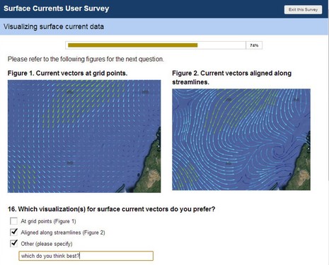 Maybe you, too, have an opinion about how predicted currents should be overlaid on electronic charts? Well, the International Hydrographic Organization (IHO) is developing an S-100 specification for "the delivery and presentation of navigationally significant surface currents" and right now they're running an online survey of all interested parties. What waters do you care about (coastal for me)? What prediction frequency would you like? Are you willing to pay? How should the data look? And more...
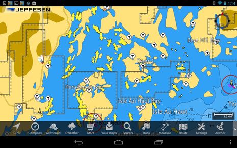 Now maybe you're thinking that current predictions are already pretty well displayed, and I wouldn't argue, but what's wonderful about the IHO's interest is the prospect of a standard that might encourage the collection and distribution of better data. In other words, the current arrows on whatever charting software or multifunction display you use may look good, but I hope you know to treat them cautiously. I only had to open the app above to get a good example. Those arrows vaguely represent what the tidal currents are doing in my cruising neighborhood as I write, but with the emphasis on "vaguely" and much more, so as you drill down on all the coves and byways that drain and fill with about ten feet of water twice a day.
Those arrows do represent the same NOAA tidal current stations that most every other provider displays, but they are not nearly dense enough to cover hydrodynamics as complicated as this coast. Plus, by definition they predict nothing about other surface current factors like big storms offshore or particularly robust river and stream outfalls. And, incidentally, this section of Maine has more than a normal share of NOAA tidal current prediction stations. I had a devil of a time figuring out the strong currents I found along the Intracoastal Waterway last fall and spring and though I'm in a powerboat these days, currents still matter a lot (at the efficient, peaceful speeds I prefer). I don't know how finer grain surface current info will get collected -- satellites? crowd sourcing? -- but I'd sure like the IHO to know that we care. Besides, the survey is short and interesting.
By the way, the app above is Jeppesen Marine Plan2Nav for Android, which is looking good in V1.1. For instance, the now available Active Captain cruising info pairs very nicely with the C-Map C-Marina chart detail. AC was also where I heard about this IHO survey, for which I'm grateful.
To be perfectly clear, I think that Plan2Nav tidal current predictions are as good as anything similar.
That said, Plan2Nav does not (yet?) let you see predictions for future hours and days, but it's got a lot else going for it.