Lusting after what looks like a breakthrough cell phone, Internet tablet, video/still camera, and PND (personal navigation device) is way more fun than fretting over FCC frustrations. Garmin surprised a lot of us when it introduced the Nuvifone in NYC this evening. Sure, it looks like an iPhone but the early info suggests that it has even more going for it, especially the GPS/navigation part, but also a tight Google relationship and fast 3.5G GSM cell data.
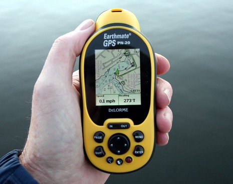
Sure, I’m a dite (or tad, dab, etc.) biased toward companies from Maine. I’d be excited about ActiveCaptain no matter where it was, but knowing that it’s home-based right across the Bay likely juices my enthusiasm a few percentile (and maybe the reverse bias is why my Navagear buds seem so oddly tepid on AC?). At any rate, it’s with some sadness that I’m about to skewer DeLorme, even though it’s not only very Maine but also built the world’s largest globe here. How cool is that? So I was pretty intrigued when I realized that the company’s first handheld, the Earthmate PN-20, was also the first ever (I’m pretty sure) to show NOAA raster charts. It’s also one of the first to show multiple cartography types and to let you purchase just what you need, when you need, on the Web. We’re going to see a lot of that model, and I think it has potential merits.
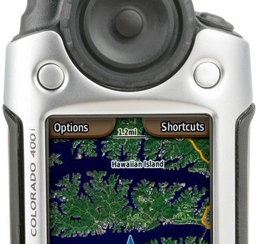
Last night Garmin announced a slew of new mobile products, and I must say: WOW! Check out the Colorado, a high-end handheld designed for driving, hiking, boating, and…um…multimedia, location-aware, gaming/educational experiences! The interface is neither old Garmin handheld nor new Garmin marine, instead featuring that big 'Rock 'N' Roller' thumb wheel/cursor thingy, and two soft keys. The wheel brings up a spinning menu system (seen right) that’s a bit like Furuno’s RotoKey.
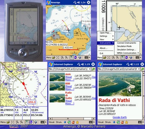
Head’s up, open source programmers. Marcello Ferrero has begun the Amerigo project, navigation freeware meant for PC, PocketPC and WinMobile phones and PDAs. A “PreAlpha” release is out, and Ferrero is hoping some nautical code jockies will join him. One feature that he thinks unique will be the ability to use a Smart Phone with camera to create a photo POI in one click, adding categories and text as desired. But I wouldn’t be surprised to see this sort of feature arrive first from ActiveCaptain’s mobile project, still “under construction”, or maybe EarthNC, or who knows where. Does anyone doubt that Web 2.0 will mash up tight with marine navigation eventually?
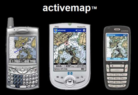
NOAA’s free chart policy strikes again! Maptech will no longer sell Outdoor Navigator, the nifty PDA (both PocketPC and Palm) and Smartphone charting program sort of shown above. The developer, Jeffrey Siegel, has decided to go independent, largely because he can now freely access U.S. raster charts and topo maps. Moreover, the program, to be called activemap, will also be free. I don’t quite understand the business plan, if there is one, but am quite sure that Jeff and his team are up to something interesting. More as available.
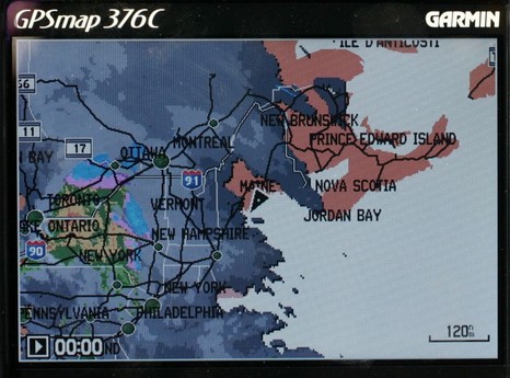
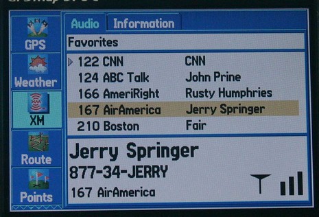
I would have posted earlier today, except that fooling with this Garmin 376C vividly reminded me (above, and bigger here) that the spell of dry, sunny weather was about to end. So I spent some hours winterizing the fleet, all the while watching the clouds thicken up from below and above. I could also see an animation of all that rain moving across New York state, plus the lightning strikes, the frontal lines, pressure gradients, wind predictions, buoy reports, etc. etc. It is phenomenal how well you can see all this info on the 376’s little screen. The display itself is exceptionally bright and detailed, and Garmin has also done a good job at letting you view the weather data mixed together or one element at a time. And, get this, I was also listening to XM radio (below). I’ve been trying the 376C intermittently over the last month or so, and am very, very impressed. It really makes sense in terms of carrying your XM weather and audio subscriptions with you on land or sea. The only con I can think of is that BlueCharts have gotten pretty expensive relative to the competition, but maybe that will change.
The Garmin 276C was one of my 5 Sail magazine “editor’s picks” for innovative, important marine electronics introduced last year. I’m working on my 2005 picks right now, and the 376C is definitely a contender. If you have suggestions for other hardware or software that should be on the list, please let me know.
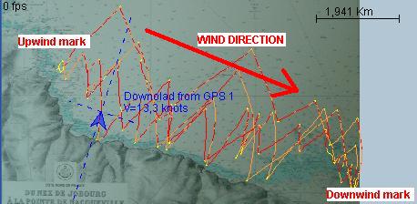
Above is output from a free program developed in France called GPSActionRelay. It is written in Java, and will suppossedly run on any operating system. Features include replay of several boats in a regatta, polar diagrams, VMG, speed averages, etc. It looks pretty complicated but apparently is used by some sailing teams and a number of geeky windsurfers. I’d like to know what hardware they carry on their boards at 46.7 knots (yi!), but couldn’t find any information. A Garmin wearable Forerunner perhaps? And if so couldn’t heart rate be graphed to speed?
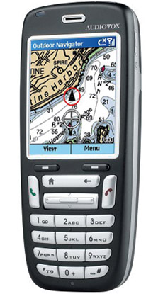
Heck, let’s make this Jeffrey Siegel day at Panbo. You see what I didn’t mention below is that Siegel is also the developer of Maptech’s Outdoor Navigator, an excellent PDA (Palm and PPC) charting program that I wrote about back in early 2002 and which has recently evolved in very interesting ways. I thought it was a pretty good deal at $100 with a year access to all the U.S. charts or topos you wanted to download, but now ON costs a mere $20 and you can keep downloading maps as long as you own the PDA it’s registered to. ON also now works on "Smartphones" using Microsoft's cell operating system. The phones from Audiovox, Motorola, and others do not have touch screens, so all ON's controls have been neatly moved to the keypad. Jeff, who naturally is cruising with all versions of his creation, notes that the lack of a touchscreen is one reason why his smartphone has an extra long battery life. He also notes how useful ON is just as a chart reference tool, no messing with a GPS, especially as Maptech corrects the charts on their servers every month. The whole ON story is here.
ACR sent out a press alert about the first rescue credited to its relatively new GPS equipped Personal Locator Beacon. I can’t find any other Web references to the incident, which involved a pair of divers off Bradenton, Florida, but it certainly sounds like ACR and the whole SARSAT system have something to brag about. The little beacon was set off “around 7pm”, seen by a GOES Satellite at 6:58pm, sent up a GPS fix at 7:01pm (presumably from a cold start), and a Coast Guard 41 footer had steamed 10 plus miles to the scene by 8:10pm. It wasn’t until 7:47 that the LEOSAR satellites could resolve the beacon’s location by the standard Doppler method, a delay that might have cost a life in this case. Hat’s off to ACR’s apparently speedy GPS PLB technology and to the fast SARSAT dispatch system! Here’s an article I wrote about SARSAT last year, ACR’s AquaFix site, and an early look at these units by Doug Ritter at the Equipped to Survive Foundation (which will hopefully conduct a thorough test of current PLBs soon).
Truly ruggedized PDA with lots of features you would like to see in such a device when using it aboard a ship.
"A company in UK called Node has developed the world's first consumer PDA designed for use specifically in outdoor environments. The device is fully waterproof to 3 meters, has a 8 hour battery life, built in DGPS receiver and 1 Gig of storage. Bluetooth and WiFi come as standard as does a touch screen and either a PocketPC or Linux operating system. I bumped into them at a tourism conference in Edinburgh where they were demo'ing the unit and I was impressed. It's smaller than a standard postcard."


 Heck, let’s make this Jeffrey Siegel day at Panbo. You see what I didn’t mention
  ACR sent out a press
  Truly ruggedized PDA with lots of features you would like to