
DeLorme PN-20, first &$?!ing look
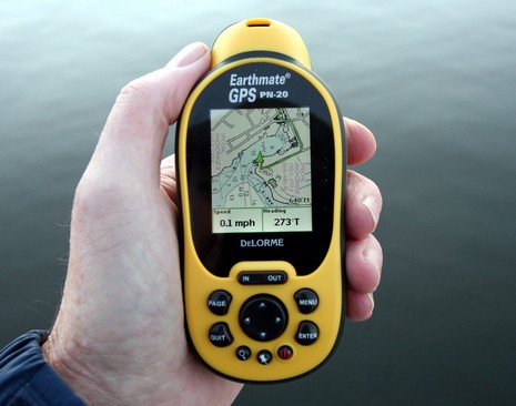
Sure, I’m a dite (or tad, dab, etc.) biased toward companies from Maine. I’d be excited about ActiveCaptain no matter where it was, but knowing that it’s home-based right across the Bay likely juices my enthusiasm a few percentile (and maybe the reverse bias is why my Navagear buds seem so oddly tepid on AC?). At any rate, it’s with some sadness that I’m about to skewer DeLorme, even though it’s not only very Maine but also built the world’s largest globe here. How cool is that? So I was pretty intrigued when I realized that the company’s first handheld, the Earthmate PN-20, was also the first ever (I’m pretty sure) to show NOAA raster charts. It’s also one of the first to show multiple cartography types and to let you purchase just what you need, when you need, on the Web. We’re going to see a lot of that model, and I think it has potential merits.
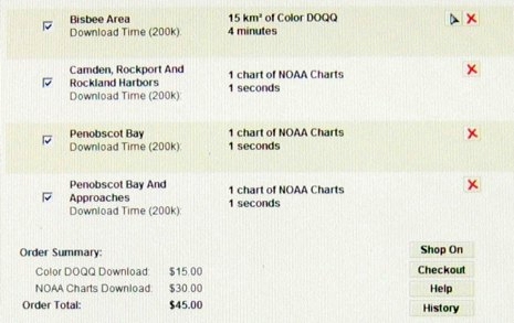
But, man, I’m pretty sure the neighbors know exactly the moment I got the loaned PN-20/Topo USA 7.0 bundle all set up and used the include $100 certificate to buy some local charts and hi res photo maps. What do you suppose DeLorme would charge to serve up NOAA charts, which for years have been freely downloadable elsewhere, and available by the whole inexpensive DVD portfolio? The unbelievable answer is below. That’s ten (10) &$?!ing dollars per &$?!ing chart! I checked the downloaded files and they’re not even reprocessed, just regular KAPs and BSBs with a small added file that I’d guess precludes using your own KAP/BSBs. And, no suprise, zooming and panning them on the PN-20 is quite sluggish. But they do look pretty good, as you can see in this larger photo. And the package has many good features I’ll cover eventually. For now, though, I’m bummed on DeLorme. What were they thinking?
I wonder why DeLorme did not support ENC instead of RNC. Vector format ENC are more compact, scale without aliasing, keep the text and other navaids properly oriented even when using a course-up orientation, support queries, etc.
I am critical of any GPS application that makes one pay for charts that are already paid for by the tax payers.