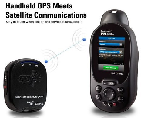
The gadget and GPS blogs are all over this combination of DeLorme handheld GPS and Spot messenger, which will apparently get official when the CES opens tomorrow. With good reason, too, because a user will be able to key a free-form text message into that new PN-60w and get it delivered from a lot of places where cell phones are useless. I didn't think a Spot could handle custom messages from the point of origin, and it sure makes me wonder what we don't know yet about the fixed marine model...
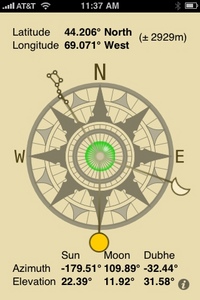
It's hard to keep up with marine related iPhone apps, and the reviews at Apple's iTunes Store often don't help. The Celestial Compass above, for instance, has seventy 1 or 2 star "this app doesn't work/sucks" type reviews versus just fifteen positive ratings, even though it does exactly what it purports to do, and that's not trivial. Admittedly 'compass' may be a confusing name, but this app uses spherical trigonometry and an ephemeris to calculate the bearings (azimuths) of three celestial bodies at your location so you can line one of them up with the screen and thus orient yourself to True North, E, S, W, etc...
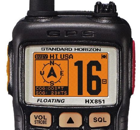
Following last week's introduction of the very interesting GX2100 & 2000 VHF/rxAIS fixed units, Standard Horizon is today announcing significant updates to its high end handhelds. I was already a big fan of the HX850S with its built-in GPS and full DSC features, but now the new HX851 takes care of my main original complaint -- lack of navigation features for small boat and back up use -- and adds a couple of cool twists...
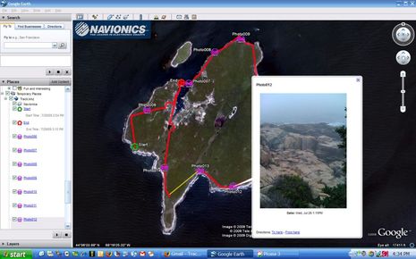
How cool is this! Most of the time we were hiking Long Island over the last two days I had Navionics Mobile 2.2 (East Coast) running on the iPhone and in track mode. Thus I could use it to check our progress against the trail map (downloadable here). I also took some iPhone photos of the mossy rich and rugged scenery from within Mobile, which then geo positions them on the chart. That's all neat, but the true kicker is that I could easily email the whole track with (reduced) photos to anyone as a KMZ file (only 248k, downloadable here) that can be overlaid on Google Earth as shown above. Or, with only two touch commands, could post it all on my Facebook page, where it seems to link to a Navionics-served Google Maps file which you may be able to see even if you don't have Google Earth or don't know beans about Facebook (like me). This easy track and photo sharing is great, but in fact the iPhone has been useful in many ways on this cruise...
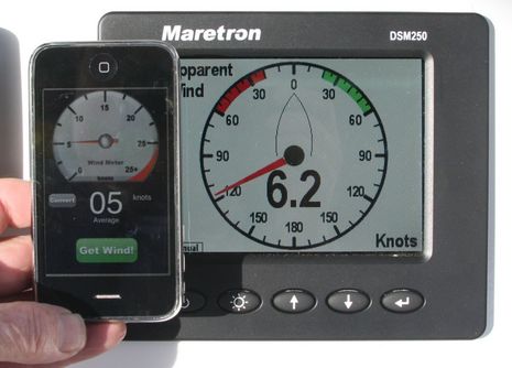
iPhone folks will notice that the one I'm holding above is upside down. That's because the Wind Meter app shown uses the sound of wind passing over the iPhone's microphone to measure its speed. And -- would you believe it? -- it actually works. I was out testing and photographing the NMEA 2000 wind rig early this morning and thus could compare Wind Meter to a consensus of five high quality sensors mounted just a few feet over my head. No, it's not as accurate or responsive as they are (especially flaky under 3 knots or so), and it apparently can't handle speeds over about 25 knots, but still...
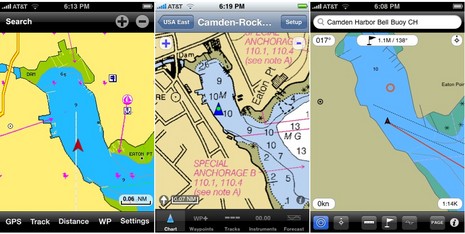
So there's a new iPhone, the 3G S, and some of its new features -- like a built-in compass, voice commands/feedback, and a much faster processor -- will no doubt benefit marine navigation applications. But I've been trying the major existing apps (thanks to a loaner 3G from Navionics), and can tell you that they're pretty seductive as is. None is perfect by any means but the three above -- Navionics' Mobile Gold, GPSNavX's iNavX, and Navimatics' Charts & Tides -- each has some interesting features. And I've assembled a super duper screen shot slide show to illustrate...
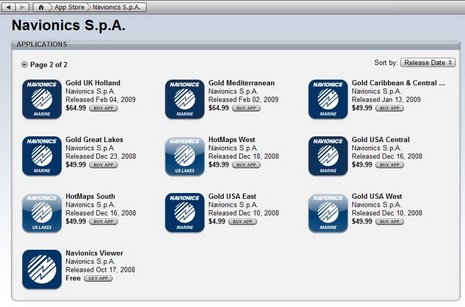
I don't usually write about rebates and sales, but 90% off!?! Navionics not only launched version 2.0 of its Mobile app yesterday, it's slashing prices. Here's the press release, and note above how the whole Gold USA East chart portfolio dropped from $50 to $5. Apparently all the chart region prices will follow -- at least to some degree (British Columbia now $10) -- in the next few days, and stay bargain priced for "a limited time this summer." A month ago I noted how fast iPhone/Touch navigation is moving, and it hasn't slowed down...
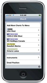
Wow, isn't an interesting crowd of chart, map, and data suppliers gathering rapidly around the iPhone/multi-other-platform X-Traverse service? I recently discussed the velocity of this and other iPhone-related developements, but was still surprised to learn today that Navionics is officially on board (Americas charts and U.S. Hotmaps available now, the rest of the world portfolio coming "in the next couple weeks"), that Hilton's Realtime-Navigator fishing overlays will go up on X-Traverse in May, and that "agreements are in place with several other chart manufacturers to bring expanded coverage and choice (raster or vector)."
Thanks to the April editon of Sailing World, I now know about the interesting and nearly free iPhone app MotionX-GPS. It's more a GPS than a plotter, and not specific to boating, but, as you can see above, it's got some boating fans. MotionX purportedly uses the iPhone's accelerometers to improve GPS performance, it supports open source mapping, and it was developed by a company founded by well known competitive sailor/geek Philippe Kahn. Unfortunately I can't try it on my iPod Touch because the it has no internal GPS, and no way to attach one (darn you, Apple!). But there are some iPhone marine apps I am trying, or will soon...
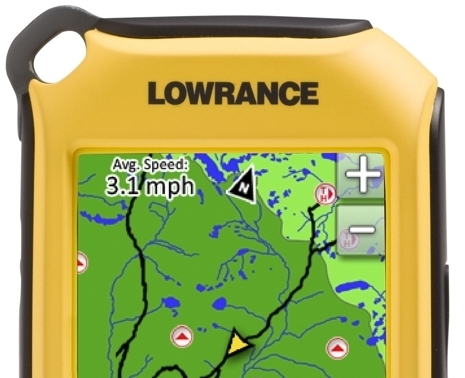
Lowrance just announced a new line of Endura touch-screen handheld GPS plotters that look like they’ll give Garmin some competition in this niche. Of particular interest, I think, is this line in the description of the Outlook model shown (it’s the base model, expected to retail at $229 when it ships in May): “Add shared web community content including routes/trails, POI’s, elevation data, etc. in GPX format through drag-and-drop to the device”…