
iPhone nav, forward in many directions
... written for Panbo by Ben Ellison and posted on Mar 19, 2009
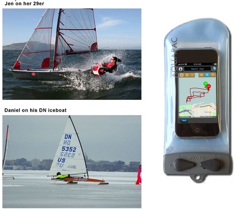
Thanks to the April editon of Sailing World, I now know about the interesting and nearly free iPhone app MotionX-GPS. It's more a GPS than a plotter, and not specific to boating, but, as you can see above, it's got some boating fans. MotionX purportedly uses the iPhone's accelerometers to improve GPS performance, it supports open source mapping, and it was developed by a company founded by well known competitive sailor/geek Philippe Kahn. Unfortunately I can't try it on my iPod Touch because the it has no internal GPS, and no way to attach one (darn you, Apple!). But there are some iPhone marine apps I am trying, or will soon...
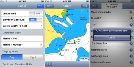 Meanwhile iNavX is working with Fugawi whose new X-Traverse service makes it possible to share data --- waypoints, routes, and certain charts --- between iNavX on your iPhone and MacENC on your Mac (now also distributed by Maptech) or Fugawi Marine ENC on your PC. In fact the X-Traverse servers are capable of doing all sorts of data sharing that the iPhone is not friendly about (if app developers participate) and Fugawi is also making deals on cartography it can distribute via the same service, so far mostly topos but they do have some Canadian lakes and Swedish charts.
I think I can try iNavX and X-Traverse on my iTouch, and intend to, along with Navimatics (and thanks to the latter two for trying MadMariner's new Panbo ad program). But really I should have an iPhone with its included GPS, which led me to trolling eBay this morning for used ones. Yike, even old 2G models with cracked glass faces are hot sellersl there! And I also need a Windows Mobile phone to check out the latest version of Active Captain Mobile as well as Memory Map's new QuickCharts (just insert SD card and the program and charts are ready to go). Oh, and it will be interesting to watch the iPhone 3.0 and nuviPhone battle out turn-by-turn car nav. Yi!
ATT is going to be dumping iPhone 3Gs ahead of an expected Apple product refresh sometime this summer. You may be able to upgrade to a 3G for $199 after March 26th.