How behind is Panbo? Well, in July I whined about Garmin’s introduction of the touchscreen Oregon handheld before I’d yet written much about the somewhat similar Colorado. While I’ve been testing an Oregon for some weeks (and still haven’t posted here about it), Garmin has introduced two new handheld/portable units of considerable interest to boaters. One is the nüvi 500 above, a waterproof, multi-mode version of Garmin’s 3.5” touchscreen automobile navigator. Which makes it a direct, and probably awesome, competitor to the Lowrance XOG and Magellan Crossover. Fortunately, the able blogsters at GPS Magazine and GPSTracklog have both reviewed the unit, though neither went boating with one. I don’t think anyone has yet seen the intriguing GPSMap 640…
It’s come to my attention that not every Panbo reader is obsessed with AIS! So how about a new charting app for the iPhone? That would be Navionics Mobile, which was just introduced at the Genoa Boat Show. It is, in fact, a relative of iNavX, the first iPhone charting app (why reinvent good code?), though obviously different. iNavX can’t download a NOAA raster chart of Genoa, Italy, for instance, and no raster chart can offer a choice of nav aid presentation as illustrated in the split screen shots above and below...
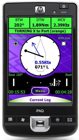
SailClever is a new kid in the sailboat racing tactical software niche, and it looks clever indeed. According to the developers, the Windows Mobile PDA screen at right “shows one of the main screens you would use while racing. It has an arrow to show where the mark is, a pointer to show the direction of current relative to the boat, navigational numbers along the top and then a bar along the bottom that shows what side of the beat you are on and your tacking angle (Downwind it shows gybe angles and reaching it shows cross track error). Pressing the menu button allows you quickly access a number of other screens that give you information on your speed relative to your polars, what the next leg is, what sail you should be using, wind direction and a basic chart.” The SailClever software will do a lot more than that, as well illustrated on its web demo pages. It can purchased alone or with a neat-looking Datasoft RS-232 Bluetooth dongle for connecting to NMEA 0183 ports wirelessly. SailClever also offers an extremely rugged TDS Nomad PDA that’s probably way out of your price range, but do enjoy the stress test video. SailClever claims compatibility with several instrument systems—sometimes two-way, as with TackTick—which distinguishes it from the higher end Ockam Eye PDA software, I think. But note that a few of its features are available in iNavX (don’t miss Gram’s latest), Memory Map, and probably some other PDA/Smart-phone apps you’ll tell me about.
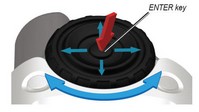
I’ve been meaning to post this photo, bigger here, for a while, as indicated by the snow in the background! It shows how the Garmin Colorado 400c screen—despite the somewhat anemic back-lighting I once bitched about—looks quite good in direct sunlight. I was also going to write a bit more about the big “Rock 'N' Roller thumb wheel/cursor thingy” that’s both quite an interesting technology (the control signals are transmitted magnetically through a waterproof shield), and the doorway to an interface I’ve come to like quite a lot. But, dang, Garmin has just announced yet another marine handheld, the similarly powerful Oregon 400c.
If Mae West were alive, her famously bawdy trademark line might go like this: "Hello there, sailor. Is that a WAAS GPS AIO PND loaded with a continent's worth of nautical, street, topo, and photo cartography and several hundred thousand POIs in your pocket...or are you just happy to see me?" To which a sorry geek like me might squeak back, "Pardon, Ms. West, no time for flirting; I've got gadgets to fiddle with!" Indeed I do.
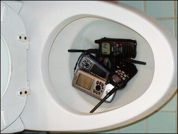
“I chastised the children for their lack of destructive ambition, handed out sticks and suggested they use the handhelds as drums, instead. They started whacking away.” Lenny Rudow’s Handheld Stress Test,published yesterday on Mad Mariner, has to be one of the funniest electronics articles ever. Plus it’s good to know what abuse these Garmin, Lowrance, Raymarine, and Uniden GPS and VHF units can take. They all survived the kids and even the flush test. I’ve always appreciated Lenny’s work—which runs from fishing to electronics—and enjoyed getting to know him when we played judges together in Miami…but had no idea how creatively destructive he could be.
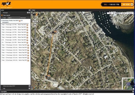
The SPOT satellite messenger is about to get more attractive to many boaters. Originally it wasn’t all that easy to share your tracking with friends and family; in fact, to do so you had to share your entire Spot account user name and password. But now Spot is beta testing a pretty sophisticated feature that enables Web sharing of both tracks and messages. Above, and bigger here, is a zoom of a shared page I recorded over the weekend; every 10 minute tracking isn’t perfect for driving, but #14 is the exact parking spot I occupied at Rankin’s, my favorite hardware store.
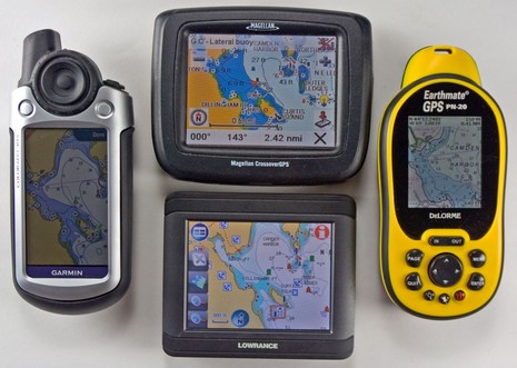
I’ve actually been testing Lowrance’s XOG for months now, and have become quite a fan. Primarily it’s a touch screen car navigator with voice directions and two gigs worth of Navteq street maps (U.S. and Canada) and three plus million POI’s built-in. But it’s also splash proof and can display all sorts of Lowrance and Navionics cartography on preprogrammed SD cards, or downloaded to your own card from www.map-select.com. What you’re seeing above, and bigger here, is an older Navionics Silver card.
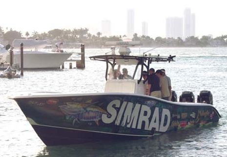
That’s me in the tan shirt, aboard the 34’ Yellowfin (run by pro Mark Maus) that Simrad used in Miami to show off its new GB40 and NX systems. I’d already covered their introduction in PMY, here and here, but still have a lot to learn about their details. The demo trip wasn’t a particularly good environment for studying details, but I did learn that both can keep up a pretty good plot even at 63 MPH! Eventually I’ll write more about the monster install in that center console, but today I want to discuss tracking that personal-fastest-ever boat ride with the test Garmin Colorado that was in my bag.
I’ve had a Garmin Colorado here for a week or so, and while there’s a lot to like about it, screen brightness is disappointing (especially given Garmin’s recent fixed plotters). Here it is alongside the DeLorme PN-20 out on Lake Megunticook near dusk this afternoon, bigger photo here, with both screens turned up to maximum brightness. Note however that the DeLorme may have the brightest color screen I’ve ever seen on a handheld, though it’s also pretty small, particularly compared to the Colorado. By the way, despite all the maps, charts, and photos each of these devices can display, I don’t think there is an electronic navigation ‘chart’ available for Megunticook in any format. Lakes are funny that way…i.e. there is no Government agency tasked with mapping them all. More on both handhelds eventually. Oh, and what was I doing out there on the ice? Well, we lost all our snow in a few rain storms, and so I’ve been learning how to use a pair of 21” Nordic cruising skates. They’re great!


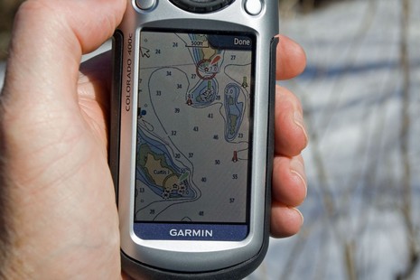
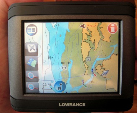
 quite good in direct sunlight. I was also going to write a bit more about the big “