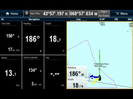
The Raymarine e7 that's been in the Panbo lab for a few weeks is proving itself quite able and well designed, but I've come across enough little glitches and omissions that I think it's also a good test of the new Ray's ability to push out software fixes and improvements. That chart window above, for instance, should be showing
spot soundings. Now it could be that I don't have the chart presentation set up right, but even if that's true, I suspect the menus involved can be improved to help a user like me. On the other hand, that screen shot is from an iPad streaming the e7 over WiFi, and that feature not only works well but continues to intrigue...
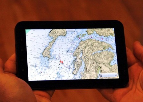
It's still in public Beta, but Memory-Map has an Android version of its charting app. I've tested it with both my Verizon Incredible phone and also with the 7-inch Galaxy Tab seen above, thanks to a loan from Memory-Map developer Richard Stephens, who I profiled way back in 2005. Even then Stephens was writing good PC and PDA charting software, and the experience shows...
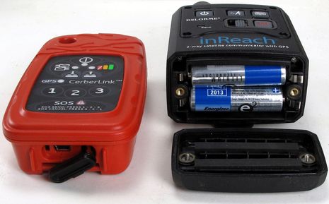
The photo above is meant to compliment the one I took when first testing the DeLorme inReach satellite communicator. It shows how Briartek's CerberLink is thinner in the depth dimension and also how it uses a USB-chargeable 2000mAh Lithium Polymer battery instead of a two AA Lithiums. And that's important. In fact it's pretty amazing how different the CerberLink and inReach are even though they're both based on the same Iridium 9602 SBD (small-burst data) modem and both aim to revolutionize two-way messaging, tracking, and safety beyond cellular coverage...
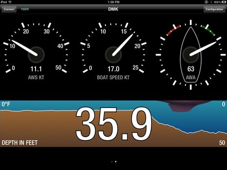
Even if it only happened in my basement lab, it really is wonderful to see a boat's sensor data arrive wirelessly into an iPad app, where it could be used and displayed in so many ways. The instrument screen shown above was developed by the same DMK Yacht Instruments folks who build the WiFi box that got the data there (first discussed here in December). The wind, depth, and speed numbers went into the DMK gateway in NMEA 2000 format, but they could have been in NMEA 0183 or SeaTalk, or a mix of all three. In fact, I've tried all three source formats with some success so far, but I'm frustrated because the DMK app -- meant mainly for configuring the box, I think -- only displays the values shown fully, and no other app I know of yet takes full advantage of what the box can do. Lets hope some developers start paying attention to what's possible here!
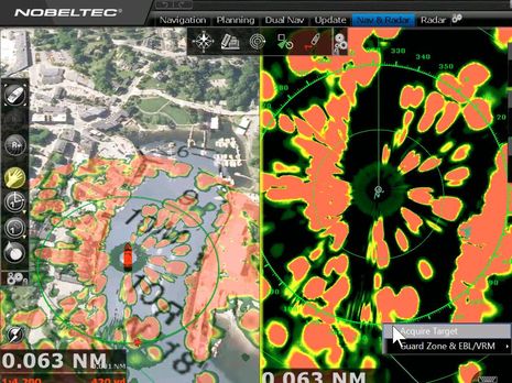
I think of the beautiful and very powerful iPad navigation screen above as a bit of a tease. Yes, that's Furuno UHD radar overlaid on Nobeltec TimeZero Trident and, yes, I could even control it from the pad as I moved around Gizmo. But there was a lot of complexity behind the scene -- like the NavNet 3D MFD12 forwarding the radar to the PC actually running Trident -- and the control was awkward as that's not a real iPad app but rather SplashTop repeating the PC screen. Then again, isn't this a tease of what should be fairly simple and ubiquitous eventually? Heck, I've already been told that Raymarine is committed to making its RayView streaming app two-way at some point, and Furuno or Garmin could make something similar happen at any time. But Navico seems to be first with a written plan, even if it includes some uncertainties...
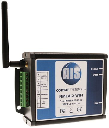
The London Boat Show opened today and so far I've learned of two products being introduced there. It's somewhat odd that while both say "AIS" on the box neither is an AIS receiver or transponder. Certainly the Comar NMEA-2-WiFi box might be used to send AIS target info to apps like iNavX running on an iPad -- and given that Comar is all about AIS, it's likely -- but in fact its two NMEA 0183 inputs could be used for any data a user wants. Having two 0183 inputs, incidentally, is what seems to distinguish Comar's product from Digital Yacht's single input WLN boxes (though worth noting that the Brookhouse iMux has 4 inputs). Meanwhile DY came up with an entirely novel AIS-related data appliance...
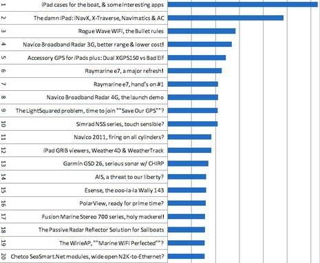
Looking back at Panbo statistics for 2011, the iPad was undeniably a major topic. The February entry "iPad cases for the boat, & some interesting apps" was the most read of the year, by far, and the next up was the "The damn iPad: iNavX, X-Traverse, Navimatics & AC" entry written back in May, 2010 (when I was lusting for one). In addition, March's "Accessory GPS for iPads..." came in at #5, and May's "iPad GRIB viewers..." at 12. So should Panbo become iPanbo? Well, certainly a major goal here is to report on and discuss important trends in marine electronics, but understanding statistics like these involves a lot of nuance...
It may not matter if you don't cruise outside the U.S., but Coastal Explorer users who do seem quite excited that the PC charting program will soon support the worldwide portfolio of Jeppesen C-Map Max charts and maybe even the older NT+ format. You can hear the enthusiasm, and learn a lot of detail about how the support will work, by checking out this CE Beta testing forum entry. Better yet, if you already run CE 2011, you can download the Beta from the same page and then use its rich chart management features to download some of C-Map's generous demo cartography...
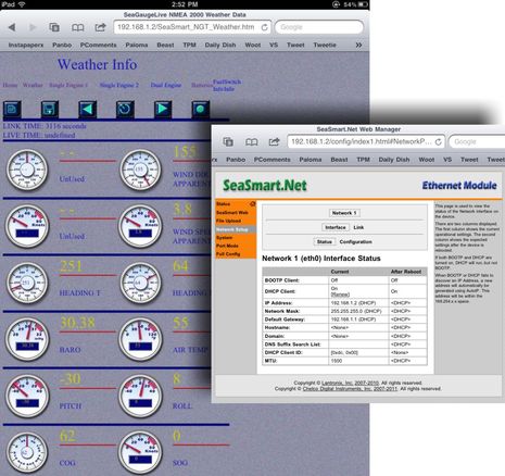
It took me less than an hour to cable a sample Chetco SeaSmart E-Net to Gizmo's NMEA 2000 network and WiFi router and use the boat's PC to scan for its IP address, which then yielded screens like the "Weather Info" browser page above on both my iPad and Android Incredible phone. Cool! And if I was actually proficient at the sort of IT stuff represented in that SeaSmart "Network Setup" screen, it probably would have been quicker. Admittedly there are some issues with that data -- Gizmo was not pitched 30 degrees, for instance! -- and I've got a lot more testing to do, but I am excited about the growing number of devices designed to gateway NMEA 2000 (and other boat sensor data) out to Ethernet and WiFi in forms that can be easily displayed, or, better yet, easily used by any software developer...
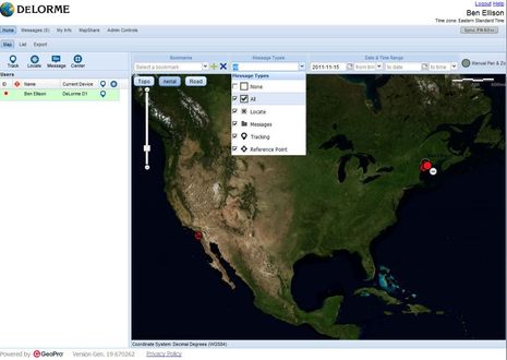
Following up on inReach hands-on #1 -- which attempted to be both an overview and a close look at its associated Android app Earthmate -- let's check out the Internet side of the system. The screen above is the user's web portal at explore.delorme.com, which DeLorme developed in partnership with GeoPro. Given that GeoPro builds its own pro-level Iridium handhelds, like its new $1,200 SHOUT Nano, it's no surprise that the portal let's you thoroughly view and manage inReach communications. It could even be used by, say, a fleet manager to keep an eye on multiple inReach units...