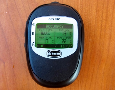
It's amazing how small, fast, and precise GPS has gotten. I'm not saying that those accuracy figures seen on the Bad Elf GPS Pro are absolutely true -- without a physical reference point, a GPS can only estimate its own positional precision, right? -- but I have seen some very impressive real world performance. Plus this Bluetooth Elf can do much more than simply feed position data to iPads, Touch iPods, and iPhones (up to five at once). It can serve as a standalone GPS with lat/long, COG, SOG, and altitude also displayable on that small but readable screen, and it can log up to 32 hours of detailed track data which is easy to make use of on your iThing and beyond...
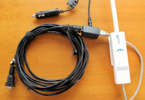
While my "hands-on # 1" enthusiasm for the BlueChart Mobile app was pretty clear, I'm not as bullish about Garmin's Marine WiFi Adapter kit. But first the good news. All I had to do was plug the black Garmin Ethernet cable above into Gizmo's test GPSMap 7212, make the other connections to the little black POE (power over Ethernet) box, and plug the results into a 12v socket {correction: Garmin is supplying 110 AC POE adapter, not 12v, see comments}. It didn't really matter where I put the adapter itself as it has the WiFi horsepower to reach an iThing anywhere on boats larger than mine. And it all just worked. Well, almost...
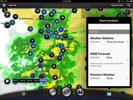
As mentioned yesterday, there was significant news today regarding Garmin's BlueChart Mobile app. In fact, anyone with a relatively current iPad, iPod Touch, or iPhone -- that is, one that's running iOS 6 or better -- can download the basic and free BlueChart app right now. And I think you should because I suspect that the app has value even if you don't go on to buy detailed charts ($30 for U.S. coastal) or the extra NEXRAD weather data (at just $4 it's nearly a no-brainer). But I say "suspect" because when I tested BCM after the Lauderdale show, the loaner iPad3 was already fully loaded with charts and Premium Weather. But I sure saw a lot to like...
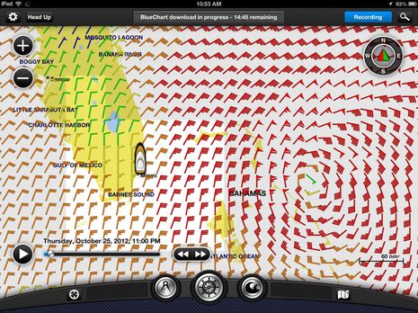
I didn't really need an app to know that Sandy was causing trouble on the opening day of the Lauderdale Show, but I was tickled that Garmin loaned me an iPad3 so I could try BlueChart Mobile (which apparently can't run on my iPad1). It's beta software -- as is the WiFi appliance that let's you share tracks, routes, waypoints, and GPS with Garmin networked MFDs -- and so they'd rather I didn't write much about it quite yet. But here's a recent and informative BlueChart Mobile YouTube video that goes with my first impression that it's a rich and well-crafted planning app that will be popular even with folks who don't own Garmin gear. Meanwhile, rumors that Garmin will have major product introductions at both METS and MIBS continue to gain steam...
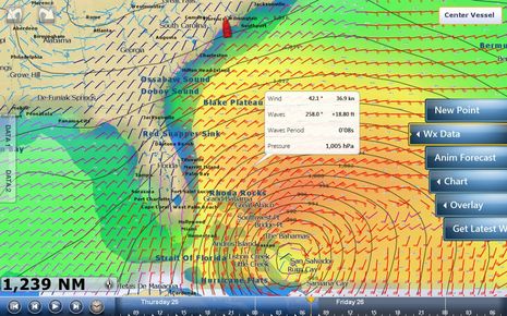
I first learned about Hurricane Sandy in an interesting way. While enjoying sunset in the Calabash River anchorage a week ago today, I was also fooling with various WiFi features built into a just-installed Furuno NavNet TZT14. Actually I was trouble shooting the seemingly flaky WiFi connection when I discovered that the TZT could connect to my Android phone's WiFi hotspot and even use that connection to quickly download a GRIB weather file. I've never seen an MFD do that before! Then I was admiring the TZT's neat controls for viewing the GRIB predictions -- like the intuitive way you can slide your finger along the forecast time bar seen at the screen's bottom -- when I noticed the tropical cyclone headed my way! But I lucked out; Sandy just slapped the Fort Lauderdale boat show around a bit, and now I'm aboard Gizmo is in a hurricane hole that's below the immense storm anyway. Today I'll be thinking particularly about other cruisers who didn't get this far south already, but I do have time to describe how Furuno is trying to do MFD WiFi different...
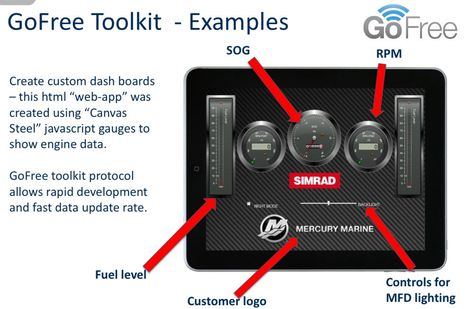
Now that we've had a look at Navico's WiFi1 router and the 0183 Link, let's examine the Toolkit that will purportedly give developers easy access to the higher level numeric data that's running around a boat's Simrad, Lowrance, or B&G systems. Of course that means NMEA 2000 info and it could lead to all sorts of interesting apps like that instrument screen prototype above. We're talking about 38 data groups ranging from GPS to Bait Well to Inverter with 303 data types already defined by Navico. I'll link to the list below and I think even non-programmers will get excited about what's possible...
I now know a lot more about the Navico GoFree WiFi strategy that we first discussed last January, and it all sounds darn good, but most everyone interested will have to exercise a little more patience. While the iOS version of the GoFree Control and Viewer app is already available on iTunes (with an Android version scheduled for Q1 2013) and the WiFi1 marine wireless hardware is slated to go on sale for $199 in November, the Simrad NSS software that will make them work together smoothly won't be out until late November, followed by the just-announced Lowrance HDS Touch in Q2 2013. And yes the rumor is true that the GoFree Control app will not be supported for non-touch MFDs like the NSE or regular HDS. But there's so much else to GoFree that every Navico system owner will likely be pleased eventually...
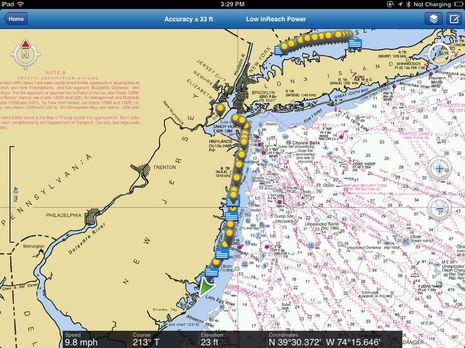
Cape May, NJ: So far, so good except that I obviously haven't yet integrated Panbo writing into my delivery/cruise routine. Sorry about that, but I'll get back in the groove now that we've slowed down and also now that Gizmo and I have our sea legs back. It's been a while for both of us! Moreover, I've had a chance to test electronics in demanding conditions -- like two night time entrances to unfamiliar harbors -- and that's really sharpened my thoughts about what works well and what doesn't. Today, though, I'm going to discuss my tracking and staying-in-touch with home strategies...
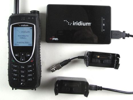
In July I tested the Iridium 9575 Extreme satellite phone and the AxcessPoint WiFi hotspot accessory that we first discussed here a year ago. Why haven't I written about it sooner? Well, this summer went by in a flash thanks the PBR, family, and my efforts to prepare boat and home for Gizmo's southern sojourn (starting this weekend!). Plus I wasn't really wowed by this gear, though in retrospect I wonder why...
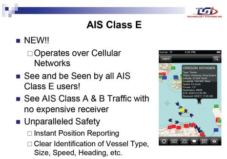
Back in March I wrote about the Small Vessel Cooperative Tracking project that the Department of Homeland Security (DHS) entered into the Small Business Innovation Research (SBIR) program. Essentially, a DHS department called the Port and Coastal Surveillance Improvement Project (PCSI) sought out an innovative way to persuade boaters to voluntarily submit their ID's and locations so that various law enforcement agencies would have better situational awareness. Well, today I get to tell you about the idea that was awarded the SBIR phase two grant of about $500,000. We won't see the results for many months yet, and there are more acronyms involved in thoroughly understanding the concept, but I think Class E AIS will eventually be a huge advance in boating safety and enjoyment...