Raymarine e7, hand's on #2
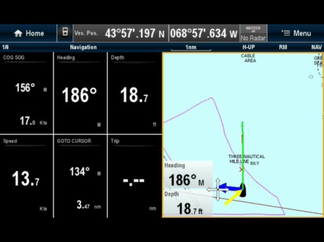
The Raymarine e7 that's been in the Panbo lab for a few weeks is proving itself quite able and well designed, but I've come across enough little glitches and omissions that I think it's also a good test of the new Ray's ability to push out software fixes and improvements. That chart window above, for instance, should be showing spot soundings. Now it could be that I don't have the chart presentation set up right, but even if that's true, I suspect the menus involved can be improved to help a user like me. On the other hand, that screen shot is from an iPad streaming the e7 over WiFi, and that feature not only works well but continues to intrigue...
Setting up the e7's WiFi and downloading RayView to an iPad or iPhone is really easy, and I think we're just beginning to comprehend how many uses there are for just the one-way streaming. Over on the first e7 hand's-on entry, an early e7 user named Brent has described how useful he finds a remote, wireless sonar image when fishing. How about a racing sailor stuck on the rail who can now see an instrument and chart screen like the one above using a smart phone in a waterproof case hanging around his or her neck? Or the skipper in his or her berth during a long passage?
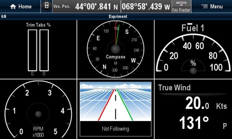
Of course the real killer app will be the promised (eventually) version of RayView that can control an e7. And of course it's also quite possible that Raymarine will make all the sensor data available to app developers, especially given that Navico has announced its GoFree strategy. But the coders at Ray probably have long to-do list already, like adding more graphic instrument display choices. On the e7 it was easy to put together a custom data screen like the one below, but those are just about all the non-numeric choices. It seems possible that an e7 could display all the great screens the new i70 instrument does, but not yet...
Another example of a valuable e7 feature that could use tweaking is Easy View. On the screen below I'm using a Navionics Platinum+ card which does display spot soundings fine, but they're not easy to see on a 7-inch screen. Of course that issue will be diminished on the new e9 and e12 MFDs that will get their U.S. debut in Miami next week, but there still may be situations where the larger Easy Few font will be appreciated...
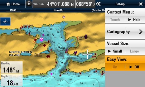
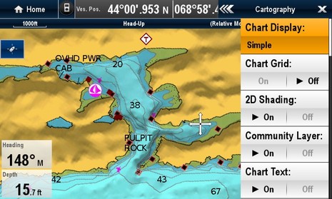
As things stand though, a user (like me) who hasn't studied the manual thoroughly may get confused about how the feature works. Touching the Easy Vew button in the Presentation context menu above immediately gets you the screen below, but it also locks the chart into the Simple display view, as opposed to Normal or Detailed (above). Now if you go to the Cartography sub-menu and try to change Chart Display you just get a double beep, so why not put the Chart Display button right below the Easy View button so you'll literally see how they interact? The upper screen also reveals a chart display problem where bottom characteristics, the "R" and the "M", are shown North Up while all the other alphanumeric info has been properly turned Head Up.
I know I'm off in the detail weeds -- those charts look pretty darn nice already, and a lot of the menu trees are quite intuitive -- but I do think many e-Series users are going to find themselves wishing for updates. It's usually what happens when a manufacturer makes a real step change in their operating system, but the ability of a company to continue the development process and get timely updates out to the field seems more important than ever.
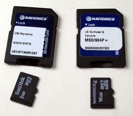
I'm going to sidetrack for a moment about an issue that can't be fixed easily, and actually applies to most all new MFDs. That's those dinky micro SD cards that have come into fashion. It's nice that two can fit easily into an e7 while leaving room for those wonderful big hardware buttons, but I don't think it would take much breeze to blow a loose one overboard, and I don't know if anyone will figure out a way to label them. Be careful!
This photo also illustrates Raymarine's new no-embedded chart strategy, which may become an industry norm. If you buy e-Series model with all U.S. charts included, it will come with that 2GB Navionics card at left (with Gold level charts, I think). But if you like all the extra goodies in Platinum+ and especially if your boat will stay in one chart region it make sense to put the $100 toward a card like the 16GB at right. In either case I'm pretty users will benefit from how easy it's become to update a Navionics chart card to "Freshest Data" using an online PC at home or elsewhere, but without the need of a special card reader. (I've been meaning to write about my positive experience with this and also with the free PC or Mac planning software that Navionics now offers card customers.)
I've also been testing the WiFi relationship between Navionics Mobile and an e7 (as well as the neato RCU Bluetooth remote control), but that discussion will have to wait. However, look back at the last e7 screen above and note the "Community Layer" switch on the Cartography sub-menu. Neither Navionics nor Raymarine has mentioned the feature yet, but it sure looks like e-Series users will eventually have a layer of user-generated content (UGC) available right on their chart plotter!
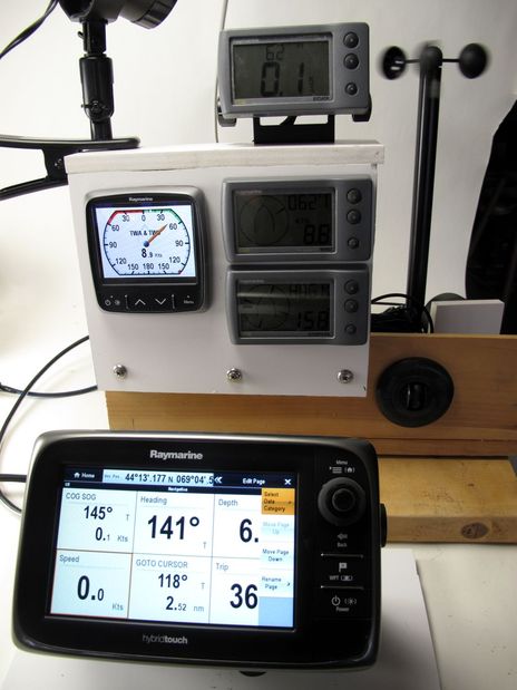
Incidentally, I've been doing my testing of the e7 testing using a powerful NMEA 0183 simulation program called NemaStudio output to the lab's N2K network using a similarly great Actisense NGT-1 USB Gateway. But I'll close with a photo of an alternate testing setup because it nicely illustrates how older Raymarine instrument systems can be updated with the new displays, and what a difference it makes. The SeaTalk data coming from that fairly complete set of ST40 sensors and displays can go right to the i70 with an ST-to-STng adapter cable (or right to an iThing using a DMK box) but better still is putting it through a ST-to-STng converter. Then all the data gets to both the i70 and e7 (and everything else on the network) and then onto WiFi if desired. The i70 and e7 also work fine with direct N2K data from sensors like the Airmar PB200 or a Garmin GPS 17x, and while Ray still likes to call it SeaTalkNG, they've started listing supported PGNs in the manuals. And I'm sure we'll be seeing lots more of the-boat-data-to-mobile-apps they've pioneered in mainstream marine electronics. Fun!

 Share
Share
Geez, just last weekend I promised more frequent entries and then I go a week writing only two! But they are getting longer, I'm not sure why, while the stack of material for future entries grows ever larger.
Incidentally, some of my lab projects may be crude but note how the ST40 system now includes a fan, a speedo exposed for finger flicking, and -- though not visible -- a PVC water tube for the depth sensor.
I've also been prepping for a 10 day Florida extravaganza starting next Monday. There's lot of new gear coming out at Miami, and some interesting demo opportunities, plus I'm going to do some small boating over in the Fort Meyers area afterwards.