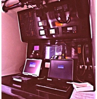
“In the foreground is a Furuno 1731MKIII radar, then behind it is a Garmin GPS162 usually left in a large map view, then there is the primary Simrad CP32 GPS which is left in a data display mode. The Simrad drives the next instrument, a Robertson AP22 autopilot. Then behind the nice Hynautic engine controls is a Dell Latitude laptop running Nobletec's Visual Navigator. Up above from left to right is the FM radio, weather telex and stabilizer controls (all out of the photo), then a B&G wind indicator, a B&G depth and speed indicator, then an Icom M-127 VHF radio which we used constantly, and finally an ICOM M-710RT SSB radio which when used causes the boat's autopilot to initiate a turn!” This is from a well-done blog I came across. Here the author is documenting an enjoyable 2003 trip down the ICW as mate aboard a friend’s 1999 Krogen 39. But there’s also a nautical sad side to the blog, which is when the author’s whole family flies to Fort Lauderdale for the dream cruise aboard their Nordhavn 46 (shipped ahead), goes out 4 miles into the Gulf Stream, then comes back to Florida, gives away all the provisions and puts the boat on the market! He’s not specific about what exactly went wrong, but this sort of thing happens more than many of us would imagine, and hats off to a guy who doesn’t try to hide it.
This is the gorgeous new schooner Maggie B. out on sea trails off Nova Scotia last weekend. I believe that big mallet is for busting ice off the rigging! Now, notice to the left the 10” Furuno NavNet vx2 on a cloth-covered extension arm. This is an almost all Furuno boat, including autopilot and an integrated computer running MaxSea. I helped the owner a bit to sort through all the possibilities before he settled on this system, which I look forward to trying some day. I am willing, however, to wait for warmer conditions.
Here’s some “what’s on board” perspective: this ‘boat’, technically a raft, is made of just four logs lashed together each day that it’s used. As you fish, the logs soak up water and the ‘boat’ loses freeboard, so when you get ashore you undo the lashing and lay the logs on a rack to dry in the sun. I have no idea how many centuries (millennia?) old this design is, but I saw the type in use all along the south coast of India, sometimes even in surf. No electronics, of course; hell, not even a nail! I took these pictures in October, 1999, a little after dawn in the fishing village of Vizhinjam, just a short walk from Kovalam, in the beautiful state of Kerala. I can still hear the babble: hundreds of fishermen messing with loggers, coming in from a night at sea in an outboard (with one kerosene lantern), and hauling a huge net that had been set into the harbor for the night…all while a mosque at one end of the beach and a cathedral at the other blasted amplified morning prayers. If you ever get a chance, go to this beach at dawn.
You’ve gotta admire John Williams’ keep-the-costs-down / keep-the-battery-full / let’s-go-sailing philosophy. The pride of his nav station (bigger here) is this antique (Windows 95), 12v sipping, pen computer (eBay, $50) which has a Holux PCMCIA GPS card (eBay, $55) plugged into it at left, and is running SeaClear charting software and NOAA raster charts (both free). John’s blog pictures the setup here and details it here, (and don’t miss his experiments with LED replacement bulbs here). This guy is having a lot of fun with a 25–year-old sailboat and some cast off electronics, though he does admit to desiring one of these. Thanks, John!
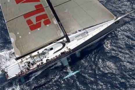
The listing is a little coy, but that’s definitely the mighty Maximus on the block for maximum millions. The equipment lists are interesting, but there are several items I can’t figure out, like:
Load Cell Pin Safe Ltd, 1 system Falcon 16 emergency system Furuno, 1 Man-overboard alert system Marine Alert, 1
Anyone? They also don’t list what software’s on the two laptops.
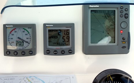
Here’s a closer view (bigger here) of the nav electronics at the “tank commander” helm of the Moorings 4200 charter cat. Frankly I was surprised that an expensive boat just a few years old only had a small grayscale plotter. The Raymarine RC425 seemed especially antiquated in Abaco, where the charts are tricky. I don’t think it was very quick to start with; today it seems positively sluggish. Plus it uses Navionics’ ‘Classic’ electronic chart format which was soon superseded by the better looking (even in monochrome) Gold format. Plus Navionics has recently added detailed private cartography to its Bahamas data (as has just about every chart vendor). Bottom line: almost all of the electronic charts I brought along were far more informative than the boat’s own.
The instruments and autopilot haven’t aged like the plotter, of course, but the speedo was also annoying. The paddle wheel was mounted in the starboard hull and only seemed close to accurate (compared to COG) on a a port tack. For instance, above we were actually doing about 7.5 knots on this starboard tack broad reach (pleasant!). The windward hull wasn’t out of the water, not even close, but I guess the hydrodynamics change quite a bit from tack to tack, making for an impossible to calibrate situation, which of course screws up the ST60’s ability to calculate true wind. Is this common on multihulls? By the way, there was an interesting discussion a while back at rec.boats.electronics about the ST60’s inability to use COG to calculate true wind.
Hmmm…reading the above I sound sour today. Truth is I’m happy to be back in Maine, even with snow coming down, but I am behind work wise. Back at it.
Geez, do I regret bragging about how wired I am here in the Bahamas. It’s not the WiFi, which so far is omnipresent in the mooring fields. It’s the fact that the 12v power supply for my laptop decided to pack up, and this vessel has neither inverter or generator to run the 110 supply I also brought. I’m down to 43% here, and will lose my PC until I can get ashore again. So you’ll understand if I’m short. Above is the helm of our catamaran, which is off center and raised up above the huge cockpit. You have fairly narrow vantage point—like a tank commander—and can’t see the sails well at all, but it does make sense overall. The boat goes pretty good. Later!
Above, and bigger here , is a ward room scene aboard the USS Salt Lake City last Sunday. It’s messy because the Portsmouth Naval Shipyard (quite a visit in itself) had already strung work lights in preparation for shutting down all the sub’s power systems. In the shot, Rich is telling the current captain, Cmdr. Tracy Howard, how in the 80’s there was a pull down screen where the big plasma display is now, and they played 8mm films from a projector in the pantry. It was just a cool coincidence that the junior officers happened to be playing that old b&w WWII sub movie as the ‘elders’ conferred.
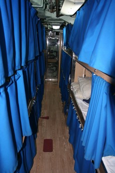
All week I’ve been thinking about that sub, and what it must be like to crew one. Rich tells me that, even on a big one like this, there’s so much engineering that not every crewman gets a private berth (which are, ahem, kind of squeezed together anyway). I even rented a documentary, Submarine: Steel Boats: Iron Men ;(excellent), to get some more feel for it. It is crowded living. While sub technology may be amazing—this one went 21 years on one charge of fuel—even more so are the skillful, gentle men who run them.
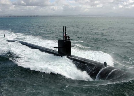
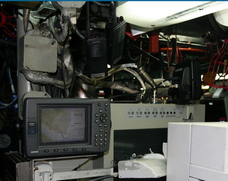
So I was excited just to get aboard the USS Salt Lake City; I can barely imagine what it was like for the 125 guys (+/-) who just cruised this technological marvel from San Diego, CA, to Portsmouth, NH, via the North Pole. Or what it was like for my dear brother-in-law, Richard Itkin, to be out there with the Russians back in the 80’s when he was the vessel’s first captain. You see my sub visit was a family event, and a sentimental one at that. Rich was on that conning tower above with his teenage son and daughter when the boat launched in 1982. What a kick then to show the controls to his 3 grandsons as the boat heads into retirement in 2006! The youngest, by the way (and bigger picture here ), is in the middle Diving Officer’s seat while the twins are in the Planesman’s (port) and Helmsman’s seats. Unfortunately, in terms of a technology tour, most all of the sub’s systems were shut down as it’s being prepared for reactor extraction. But suffice it to say that there are lots of places on the boat where the instrumentation is as dense as in this photo. Most of the gear is quite sub specific, but the Garmin plotter wasn’t the only COTS surprise. For instance, there was also Furuno sonar gear aboard, used during the last trip to look up at the ice, and judge its thickness. The USS Salt Lake City was able to find a thin spot and break through for a brief look at the North Pole. (Which makes Rich jealous; I would be too).
I knew the Navy used some regular marine electronics and even has an appropriate acronym—COTS, for Commercial Off The Shelf—but I was still amazed to see a Garmin 2006 tucked amongst the massive jumble of gear in the control room of a 360’ U.S. nuclear attack submarine. And what the hell was I doing on a submarine yesterday? More later.


 big plasma display is now, and they played 8mm films from a projector in the pantry. It was just a cool coincidence that the junior officers happened to be playing that old b&w WWII sub movie as the ‘elders’ conferred.