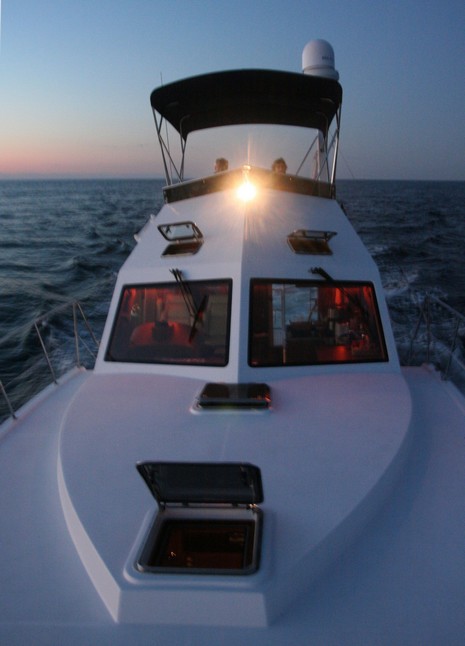
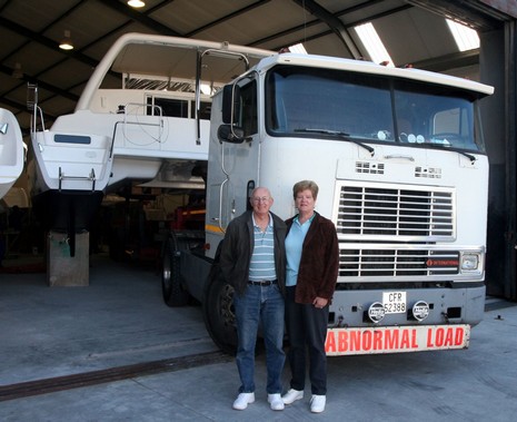
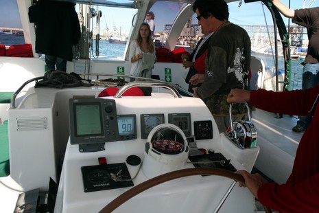
This is the helm of a Robertson and Caine Leopard 46, sometimes thought of as the Moorings Leopard 46 since this huge charter company is the builder’s main client. R&C is the biggest boat shop in South Africa, 14 hulls under construction when I toured the other day, one being launched every six days (the pressure was palpable). The boat above was just commissioned and may already have left on a 7,000 mile delivery to a Moorings base in the Caribbean. The electronics surprised me in two ways: * The plotter is the same damn Raymarine RC425 I was disappointed to find on an older Moorings Leopard 42 last winter. I didn’t even think this unit was still available. I guess its presence speaks to how easy it is to navigate where this boat charters, and how unwilling the actual owner is to put better gear in the hands of charterers. * But that doesn’t explain the TackTick wireless and solar powered instruments (bigger helm shot here). Apparently the Moorings has specified these on all new boats, and no one could tell me why. I think TackTick gear is very cool, but am really surprised that the Moorings would want to deal with another supplier, and more expensive gear at that. Anyone know the story? Long distance deliveries, by the way, are part of South Africa’s boatbuilding success. The young man on the bow above has logged 35,000 miles already this year, and the hand on the wheel belongs to R&C’s delivery manager who’s talking daily via Iridium to at least two vessels bound to the Caribbean, West coast of Mexico, Med, Australia, somewhere. It’s quite possible for owners to join these trips. In fact, Admiral Yachts, which specializes in cruising cats for Americans, includes with every boat sale a pair of plane tickets to Cape Town, two weeks in seaside apartment while your boat gets launched, and then the services of a pro delivery captain/instructor to get you to the Caribbean. That’s the story in the photograph below, bigger here, as Harlin and Brenda Allen watch their Admiralty 38 Banana Split leave the factory. Look for them in Trinidad in about six weeks. It was a pleasure meeting them, and we all enjoyed the South African expression for “wide load”. Aren’t all boats Abnormal Loads?
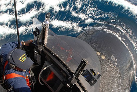
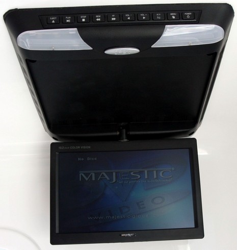
It is famously hard to photograph rough seas, and this (bigger here) is a good example. Only a bit of spray and Mark Delaney’s two-handed grip on the grab rails suggests that his Two Oceans Magnum 32’ sport fishing cat is slamming along at 20 knots across steep and confused five footers piling up just outside Cape Town Harbor. That crazy Frenchman is my new good buddy Laurent Fournier, the only other writer on this press tour, and it was his idea to test this boat in less than smooth conditions. We got way more than we bargained on, but it certainly confirmed the contention that South Africans tend to build serious boats because they boat in serious waters. Elsewhere in the world this test would likely have been postponed but Mark had no qualms about subjecting his boat to some real pain. In the process he proved beyond doubt that the hull he and his father Rod developed leans nicely into fast curves—unlike many power cats, which lean unnervingly outward—and also has enough reserve bouyancy forward to resist burying its bows even while surfing in extremis. The Delaneys favor Furuno electronics, both here and aboard a crackerjack Two Oceans cruising cat I toured. The latter even has a Furuno autopilot, the first I’ve seen on a sailboat (excellent preformance reports Rod). The Magnum also had the all-in-one DVD player below, from a Australian company called Majestic I’d never heard of. Mark says they hold up, and that’s saying something. It turns out that further up the African coast, where tuna are plentiful but harbors are not, Magnums and similarly tough boats are beach launched through surf using big wheeled tractors and special trailers. Serious about fishing too!
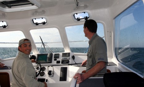
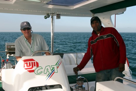
Well, I’d figured that posting might suffer, but I had no idea how long a two day plane trip and a miserable hotel WiFi voucher card system could knock me off line (why is it so easy to serve Internet via WiFi, so hard to charge for it?). If you’re reading this, then I’ve figured a way to update Panbo via the hotel’s “business center”, and we’re back in business. Which starts with my first boat ride in the southern hemisphere. While the electronics—Raymarine ST60 wind, depth, speed and a JRC 1500 radar—weren’t exotic in the least, the boat was. Fuji Cat is a Scape Yachts 39’ multihull purpose built for day sail chartering. Hence the “bug eye” hard dodger—odd looking, but very effective off Cape Town where the ocean is wide open and cold, and the weather changes fast—plus the on-center helm with all sheets led to it under the platform, and thus out of finger pinch range. The hulls are fairly narrow, construction fairly light, and Fuji acclerated quite nicely even with about dozen bodies on board. There’s a “sport cruiser” model that’s clocked runs in the high 20’s, and can fly a hull if you’re up to it. Meanwhile I’ve been to the Cape Town Boat Show, and am getting a feel for how vigorous the boat building business is here. In more general sense, things are sometimes oddly familiar, other times a bit different. I just heard “Sweet Home Alabama” playing on an FM station, but that plate on Fuji’s snack bar features “South African sushi”—the local joke name for beef (I think) jerky.
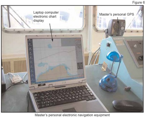
OK, it’s not exactly glamorous to drive a cargo ship full of used cars out through Germany’s Keil Canal and than across the Baltic to Lithuania, but it was this unfortunate skipper’s first command. That’s why he couldn’t rest well during the already stressful 6-on/6–off watch schedule (only two deck officers!), and possibly why he let the lookout—who was also the cook and about to be relieved the next day—go below to clean the galley for the next guy. Result? The captain fell asleep so solidly that Lerrix went a full hour past a turning mark before it went aground, even though VTS (vessel traffic service) operators were trying to warn him by radio. Yes, readers, I’ve been dipping once again into the rich archives of the U.K.”s MAIB (Marine Accident Investigation Bureau), and finding yet more dope that should make you very cautious about big ships. An interesting aspect of this particular case, detailed here, is how minimal the ship’s electronics were, though up to Brit code, and how funky the skipper’s own setup:
“Lerrix’s bridge equipment met the criteria required for the flag state {U.K.} Safety Equipment Certificate. Although compliant, the navigation equipment fit was basic, consisting of 3cm and 10cm radars, neither with an ARPA facility, an echo sounder with a paper plot, and stand alone AIS and GPS sets. During the investigation, it was noted that the master carried his own laptop computer from ship to ship, complete with a hand-held GPS. Loaded onto the laptop was a pirated programme of Transas electronic charting, which he had downloaded from the internet in 1999. The hand-held GPS, which the master had secured to the bridge console, provided the positional information for the laptop’s electronic chart (Figure 6). Examination of the programme showed that it had not been updated since 1999, and the charts on the system were based upon 1999 data. The downloaded software did not provide any of the optional operator functions, such as warnings and alarms.”
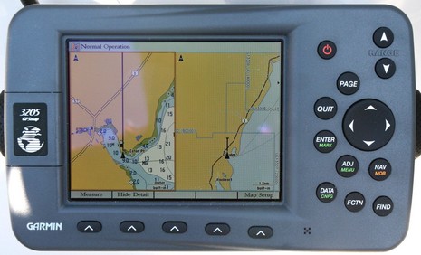
So I spoke to “the boys” on Saturday; they’d had a great first sail on their own. Good Enough is slippery, as I saw myself (note the 6.3 knots on the GPS, relatively flat seas in background). And, good news, Jo found himself getting more comfortable with his Garmin. Here's a bigger shot of the screen above, showing some of the things I set up that may be helping him: * In Map Setup, the Prefs sub tab, I put Orientation to “Track Up”. Now I know that some salts think North Up, paper chart style, is the only way to go, but I’ve come to believe that head up makes it easier to sort out what’s important on these little screens. That’s especially true on this Garmin (the Navman 8120 too) because Track Up and Course Up automatically put the screen into a “look ahead” mode so you see more chart ahead of the vessel. * In the same setup page, Nav sub tab, I set a Heading Line based on a distance of 1 nautical mile. I always set up one of these lines, which I think Garmin should be calling a COG line (there could be Heading line too, like on a Raymarine, but it would be based on compass input). Usually I use time, but in this case, with inexperienced users and those tiny lower right map scales, the 1 mile really helps the eye to understand the current chart scale easily. The effect is pretty obvious on this Split Chart page, which I think is another boon to maximum situational awareness on a minimal screen. * Finally, I also goosed up the spot soundings font size in the Labels sub tab, but I’m not sure that helps. I really wanted to enlarge the nav aids but couldn’t figure out a way to do this. Anyone? Or do you have any other ideas on how to make a small Garmin screen as easy and informative as possible? Do tell!
PS. In regard to inspirational old boat guys, I’m happy to report that my buddy Max didn’t last long without one. Plus: Sir Robin Knox-Johnston, who won the first non-stop race around the world, aka the Voyage for Madmen (excellent book), is doing it again.
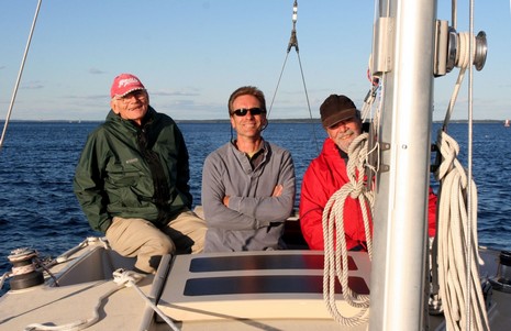
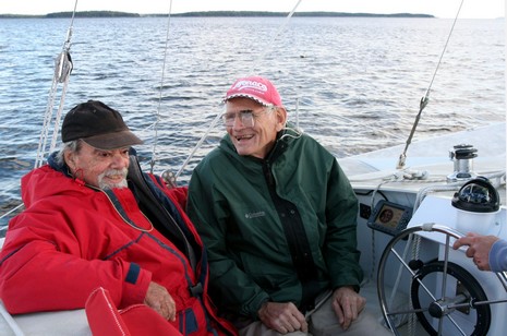
Multihull sailing fascinates me anyway, but yesterday’s scoot around the Bay was inspirational and momentous. That grinning dude, bigger picture here, with the magnifying lens clipped to his already serious glasses is 73–year-old trimaran designer Jim Brown, who I’ve had the pleasure of knowing since my days in the 80’s running WoodenBoat School, where he and longtime boat-biz partner John Marples taught a wonderful class in Constant Camber multihull construction. Jim’s had macular degeneration nipping away at his vision for some fifteen years, and his good buddy Jo Hudson, 70 himself, is sporting some brand new artery stents. But yesterday was, in part, a test sail preparatory to Jo and Jim taking off today, headed for Jim’s dock in Virginia. And they’re dreaming about the Azores and an Atlantic circle starting next April. That’s the inspirational part! The momentous part is that Jo just bought Good Enough from Steve Neil, center below, who took Jim’s class in 1986 along with his dad, for whom he (beautifully) built this 35’ Constant Camber Marples-designed trimaran. Steve went on to build several other multis, took this one over after his dad’s passing, and is now production manager at Wayfarer Marine. It’s not easy to give up a boat with so much personal history, but he and his mate Diane (chasing us in a photo boat) seemed delighted about turning this one over to Jo and Jim. And, yes, there was a marine electronics element. Part of my function yesterday was trying to orient the old guys to the Garmin 3206 that Jo just bought and Steve installed. It was a challenge. This is a pretty complex machine, with a lot of buttons, and Jim can only see it by putting his magnifiered eye inches away. I tried to set it up to be as useful yet straightforward as possible—more about that in part 2—but Jo still found it overwhelming. Hopefully, he’s making friends with his 3206 right now, on the open Bay. If you live or boat along the Northeast Coast, keep an eye out for these old cats!
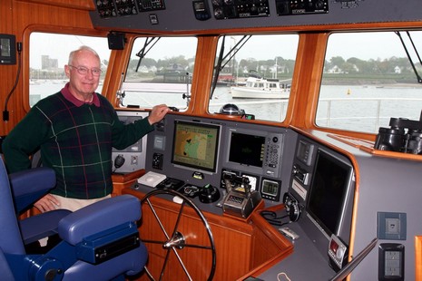
Above, and bigger here, is a proud Milt Baker at the helm of his Nordhavn 47 Bluewater, a just-one-year-old vessel that he and his spouse Judy have already cruised over 7,000 miles. The couple were already very experienced when they founded Bluewater Books & Charts in the mid 80’s (coincidentally their last Bluewater was a Grand Banks 42, like the one outside the window in Rockland, Maine, on the drizzly day I visited). Now, in retirement, they are really out there doing it; this vessel is meant to take them to Europe next spring. Milt gave me a good systems tour but fortunately I don’t have to repeat much of it as he’s put a complete electronics list, even PDFs of the layout (that he designed in AutoCAD), at their BluewaterNav Web site.
Now I like “belt and suspenders” as a folksy expression for redundancy, but it doesn’t do justice to Bluewater. Let’s see: Two complete autopilots, every component; two 10.4” Furuno NavNet MFDs, networked but each with its own radar scanner, plus a 7” in the master stateroom; and a laptop running Nobeltec Admiral to twin 15” monitors, with three backup Admiral-loaded laptops on board! There’s more redundancy, and more Bluewater gear to write about, but can we agree that it’s very unlikely this boat will drop its navigational pants?
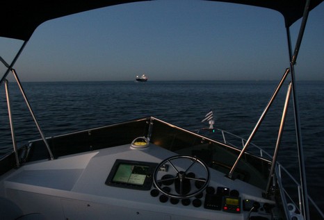
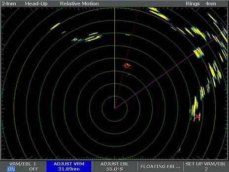
Crack of dawn, really, and nearly flat calm as we’re inside Cape Cod Bay, Race Point/Provincetown on the port quarter. In the bigger version of this picture you can see some shore lights around the entrance to the CCC, as the Canal is called, from whence that ship emerged. You can also see the remnants of the bothersome light leakage I wrote about the other day, coming off the steaming light just below the compass and a little also off the green running light forward. Note that the engine gauge lights aren’t on because my mate Rich is actually running the boat from below, and Volvo automatically switches gauge lights with engine control (nice). But I had been up on this bridge from the very wee hours of the morning and, though it was clear, had much appreciated the quality of the Raymarine radar. Check the screen shot below, full size here; with the E-120 set head up at 24 mile range, that’s Race Point off my port bow, a MARPA target in the ship channel to Boston, and Cape Ann on the starboard beam. I’ve used the VRM to note that the boat’s relatively dinky 4kW dome scanner is seeing the Boston RACON buoy about 32 miles away, which seems quite good. A couple of days later we ran into thick fog when entering Fisher’s Island Sound and learned that this radar could also distinguish little outboard boats at close range, again all settings on ‘auto’. Impressive. I think the scanner may be one of Raymarine’s new models, which they’ve been rather quiet about, but I need to check that out. Eventually I will also tell you about the problems we had with this radar (nothing to do with the scanner). In the meantime, have a wonderful weekend, which is a three or four day end-of-summer Labor Day special here in the states. If you’re anywhere near me, you really should check out Windjammer Weekend, especially today’s gathering of the fleet.
Funny that just yesterday I referenced my own submarine experience, which involved a Garmin, and today two Panbotes tip me to an AP article about the brand new 377’ nuclear sub Texas, with a cool picture of the conning tower that just happens to have a Garmin 278, 376 or 478 stuck on its windshield (even Garmin doesn’t know which). I think I see a large screen mounted down lower—which goes with AP’s description of the sub’s high tech systems, even a fiber optic periscope—but the screen doesn’t seem to be on. Maybe the software is ‘delayed’, as they say (as if software could get a flat tire on the way to work), so someone went to West Marine and bought the Garmin? At any rate, bad guys on foreign shores should note that the USS Texas, among other lethal abilities, “can travel with a small special forces submarine, nine commandos and their gear”.
We’re on our second day of gray and wet here in Maine, and I’m missing that summer passage on Shanghai Baby. This shot shows us at sunset, Andrea and Rich, the-ex-sub-captain-brother-in-law on the bridge, about a quarter of the way across the Gulf of Maine on a straight shot from Monhegan Island to the Cape Cod Canal. We did the whole leg—Camden to Cuttyhunk nonstop in 25 hours—at about 1300 RPMs, or 7.5 knots, which got us about 2 miles to the gallon, a quiet ride, and a gorgeous night offshore. The electronics angle? Light pollution! That damn steaming light leaked annoyingly into both helms, a shame because otherwise both had good visibility and good control over the electronics glow levels. I’m not sure it would be legal to move the nav light to the antenna mast, which is offset because it also serves as the tender crane, but I’d sure look into it. When running at night, getting the lighting right around the helm is important.


 Steve went on to build several other multis, took this one over after his dad’s passing, and is now production manager at