Well, hot damn! How about a full featured PC planning product that includes maps for 10,000 U.S. lakes, all on a $20 DVD? I just heard about it this morning, but my first impression of Navionics HotMaps Explorer is “who wouldn’t?” Well, I suppose if you never, ever go out on lakes, but I do and was pleased to see that the coverage list includes a lot of Maine lakes. Now my favorite, Lake Megunticook, is not covered by any digital map maker, I don’t think, though I keep hoping that Navionics will do one of its high definition surveys there and let me see at least some of their techniques. By the way, the download of one HD lake map is included in HotMaps Explorer.
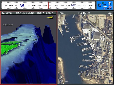
If you own a Raymarine E-Series MFD, you are about to get a lot of free new features—and some new accessory shopping possibilities!—thanks to a V4 software update coming this month or next. The screen above shows the new “steering bar” as well as support for Navionics Platinum+ chart cards and—bigger here—their much improved photo and 3D resolution, even if the docks are on the Cape while the banks are in the Bahamas (for more on Platinum+ check out this video).
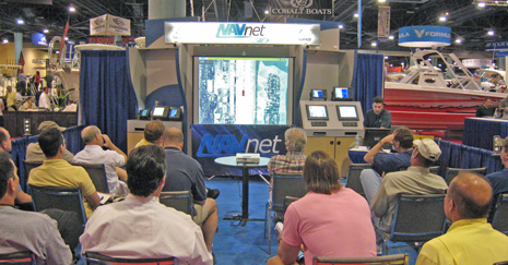
Almost every time I walked by Furuno’s demo area just outside the MIBS madness Electronics Room, it looked like the scene above, i.e. full of folks intently learning about NavNet 3D. But while last Fall’s NN3D buzz continued, the negative word around MIBS was that Furuno didn’t yet have a shipping date, and wasn’t even taking orders. “Nice system,” competitors said, “but you can’t get it!”
Well, I’ll be darned. As Damon pointed out in the screenshot entry, the Northstar M Series also has the feature. It’s not hidden either; I plugged in the lab’s test M121, and the command is right there on the System menu (ahem), and self explanatory. I did hit a snag creating a “User Card”, though; it took a call to Northstar support to find out that it can’t exceed 512 Megs and, sigh, those cost as much as bigger cards these days. At any rate, one is on its way, and soon I’ll put the unit through a Kagstrom AIS simulation.
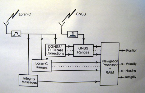
Remember all the hand wringing about shutting down the Loran system? Well, the inimitable Langhorne Bond was right again; the USCG’s threat was in fact just smart politics. President Bush’s 2009 budget “migrates” Loran responsibility from the Coast Guard to another Dept. of Homeland Security (DHS) unit called the National Protection and Programs Directorate (NPPD). The budget further states that NPPD will be responsible for finishing the transformation of Loran-C to Enhanced Loran (eLoran). On Feb. 7, DHS announced eLoran will not only back up marine and aviation GPS navigation, but enhance navigation for “first responders” and others operating in difficult GPS environments. This is a big deal.
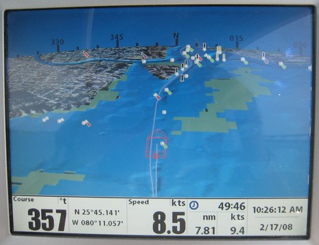
Some day I’ll figure out how to use the “tag” function built into this blogging software, and this entry will be one of several easily found by clicking “Smart Interface Ideas”. I’ve never seen a compass rose overlaid on a 3D plotter horizon like this, but it struck me as totally intuitive, very useful, and without a downside. Check out the big image and imagine yourself driving up Biscayne Bay toward the Miami River and the MIBS madness beyond. Notice how 3D gives you buoy and bottom detail near your position plus a good, if less detailed, sense of what’s ahead. (In this particular case the bottom contours aren’t very emphatic, but if you look at the 2D raster of the same area, you’ll see there isn’t much depth differentiation around here, and there was probably a tweak we could have done to emphasize it. It’s also evident that the wire frame boat icon is a bit large, putting the green lit mark in the galley!)
I wrote about the nifty target tracking abilities built in to NVTI’s high end multi camera devices a while back, but got to see them in action in the MIBS electronics room. The engineer/demonstrator used that show goer’s hot face to show me how the model 6000’s own computer could lock onto a thermal target and command the camera to follow it. In fact, it tracked the poor guy for about 100 feet as a strolled down the aisle, actually felt like someone was staring at him, and then discovered himself on the NVTI monitor. Things get weird like that in the electronics room. The camera was also impressively able to lock onto the end of a swinging six foot radar array way across the room, which made for dizzy imaging, and I bet it would have worked fine with that cold glass of beverage above. Note, too, the ARPA radar targets listed lower left on the screen above. Pick one and the multi camera casing swings to it pronto. And the latest feature is that AIS targets can also be listed across that monitor, subject to instant tracking. Cool!
This ST70 not only plays pretty well with the various non Raymarine sensors on Panbo’s NMEA 2000 test network, as mentioned earlier this week, but it’s also loaded with neat surprises. One is those little minimum and maximum dots on the outer ring of the digital Apparent Wind dial above. Many instruments will track min/max of some values, but I’ve never seen one that does it graphically like this. Have you? Plus when you press that menu button from this page, your first choice will be to reset those min/max values. Friendly.
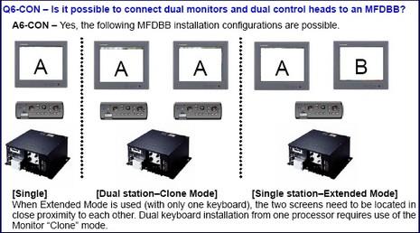
I don’t know when NavNet 3D will actually ship, but the nitty gritty details are emerging. There’s a very useful NavNet 3D FAQ (PDF) up at Furuno’s “Learning Center” (lower right, under Reference Materials). I’ve only skimmed it but was pleased to read how nicely NN3D handles multiple N2K GPS, depth, and other sensors (you pick a preferred sensor and the whole system will honor that preference unless it fails, when a backup will automatically be used). There’s also a good explanation (above) of the blackbox version’s support for multiple monitors, a great feature that’s hardly been mentioned yet by mutts like me. Fortunately, too, a Panbo reader with a strong personal interest in NN3D sent me notes on the FAQ—some enthusiastic, some skeptical, and some perhaps based on misunderstandings. Check it all out and add your own two cents:
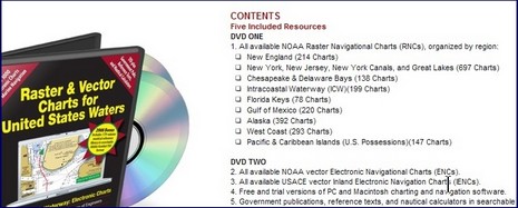
In our Panbo discussion about how to tune up your electronics and general navigation gear for the coming season, one recurring suggestion was to update your charts and reference publications. Another, less obvious, idea was to get all your manuals in PDF form, which many find easier to search, not to mention stow. Well, check out Managing the Waterway’s 2008 chart and pub DVD set, a phenomenal collection of both NOAA (and Corp of Engineers) charts—every single one available, raster and vector—and the nautical publications made available by various government and state agencies as PDF’s.