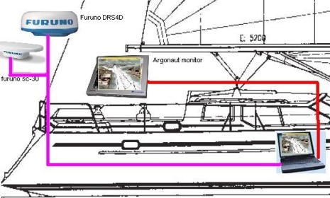
Can Panbo reader Rolf network the NavNet 3D version of MaxSea Time Zero straight to NN3D radar and GPS compass aboard his Regina 43 (as he graphically dreamed of above)? The idea seems conceivable given that NN3D radar scanners are independent Ethernet entities, and can even bridge in NMEA 2000 sensors, but I’ve confirmed from Furuno that you must have at least one of its NN3D processors in the system. That’s because only a Furuno MFD or Black Box can be the Master of a network, able to “act as a DHCP server and distribute IP address to any other Ethernet device (Radar Antenna, Sounder, Computer, ...).” MaxSea Time Zero is going to work nicely in an NN3D network, sharing charts and all sensor data, but it can only be a “slave” in terms of network architecture (and it also won’t be able to do some configuration tasks like aligning a scanner).
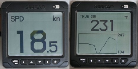
If the Furuno FI-50 family featured yesterday are segmented LED old school—and the color all-in-ones can display data any which way (if the page designers get their butts in gear)—then Simrad’s IS20s are the middle school of N2K instruments. Aside from four analog-look dedicated displays (can’t call stepper motor driven hands responding to N2K smart sensors actual analog, can we?), the IS20 family has the Combi and the Graphic displays shown above, and bigger here
. As best I can tell they use the same dot matrix screen, but the Combi is limited to four preprogrammed screens showing only the data sourced below left (“position” is really about SOG). In fact it can be installed as a stand alone—just plug in smart triducer and SimNet power cable—and is similarly simple to use.
So I may be on semi vacation, and having a time, but I’m still looking forward to getting back to the lab where the network of NMEA instruments recently grew to include Furuno’s and Simrad’s latest. Check out the big picture here . I’ll be writing a comparative overview on these five brands soon after I get back, and I’m trying to sort out factors to check out. So far I’ve got:
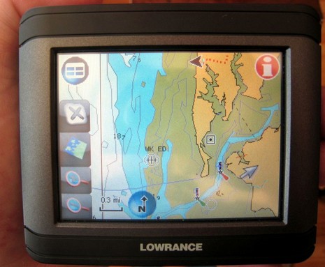
I’ve actually been testing Lowrance’s XOG for months now, and have become quite a fan. Primarily it’s a touch screen car navigator with voice directions and two gigs worth of Navteq street maps (U.S. and Canada) and three plus million POI’s built-in. But it’s also splash proof and can display all sorts of Lowrance and Navionics cartography on preprogrammed SD cards, or downloaded to your own card from www.map-select.com. What you’re seeing above, and bigger here, is an older Navionics Silver card.
There’s been a slight change in the GPS satellite system and it’s messing up some older Northstar sets—i.e. certain 941, 951, 952, 961, and 962 Navigators, depending on their software version. Northstar has a tech bulletin online, along with a more detailed PDF.
Today Faria announced that it had acquired “certain marine-related software products from Maptech”, as well as several former engineers. Of course that must mean the Touch Screen Navigator program that Faria is putting into its Maestro System.
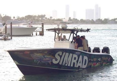
That’s me in the tan shirt, aboard the 34’ Yellowfin (run by pro Mark Maus) that Simrad used in Miami to show off its new GB40 and NX systems. I’d already covered their introduction in PMY, here and here, but still have a lot to learn about their details. The demo trip wasn’t a particularly good environment for studying details, but I did learn that both can keep up a pretty good plot even at 63 MPH! Eventually I’ll write more about the monster install in that center console, but today I want to discuss tracking that personal-fastest-ever boat ride with the test Garmin Colorado that was in my bag.
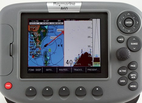
I remembered this Raymarine A60 today because Jim Hebert just did an up-to-date bench test over at Continuous Wave. I tried the unit alongside a Garmin 545S last summer and wrote about it for last October’s PMY. It also came up when the WAAS satellite change happened and I gather from Jim that Raymarine was never able to fix the RS12 GPS that’s bundled with the A60. An expensive fix is possible, but note that it did well in my testing without WAAS, and that the Raymarine A-Series page indicates that its price has dropped a lot since my PMY piece.
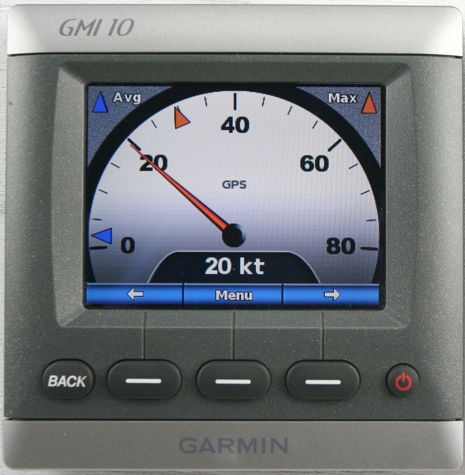
Good things first: some of the display pages available on Garmin’s new GMI 10 are fantastic, at least as gorgeously graphic and data expressive as the official product photos (like the one we used in the April PMY). Check my real world photo of the speed dial above, which can even have those Max and Avg markers something like the useful Max/Min dots seen on the Raymarine ST70. One button step into the menu system and you could use STW (Speed through the Water) instead of GPS, assuming the paddle wheel sensor is on your network, and a little deeper you’ll find a thoroughly annotated list of all your network devices and the ability to choose which you want as a preferred source. And, yes, that screen is exceptionally color rich and well back-lit (using a direct 12v feed, as Garmin chose not to power it off the N2K network). Altogether, and along with the ST70, rich NMEA 2000 data networking plus color screens and processor smarts equals a great new generation of marine instruments. But!
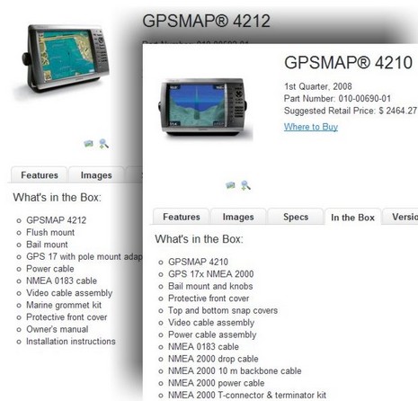
It’s fabulous that Garmin is now including, or at least plans to eventually include, a NMEA 2000 17x GPS and starter N2K backbone with its 4000 and 5000 Series networked displays (even if it took almost a year to get it all together). But if I were shopping for one of these units today, I’d be darn attentive to exactly what’s in the box. The switch from 0183 to 2000 sensor systems appears to be in transition, and I don’t know how far it’s progressed or what may still be in the supply chain (or if there is any price consequence {nice update: “no price change”}).