At least one Navico competitor is having fun e-mailing around this scan of a major ad blooper that ran in a New Zealand marine publication. Of course the intended headline was “True Multifunction” not “True Malfunction” and no doubt some one is very embarrassed about the mistake. In fact, “multifunction”—as in multifunction display, or MFD—is not a term that has slipped easily into boating vernacular. The forwarded email that carried this image was jokingly titled “Truth in Advertising” but therein lies an unintended truth. Aside from the blooper, this ad better represents the actual product than some of Simrad’s other marketing.
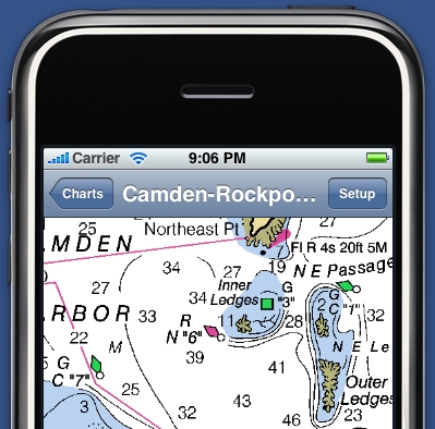
On Saturday the Apple iPhone app store started offering iNavX Marine Navigation and it’s already generated eight mostly positive reviews there. The $50 program is the work of Rich Ray, who also developed GPSNavX and MacENC, and it looks similarly well done. It works with the built-in GPS of the new 3G iPhone of course, but can also be used on older iPhones using cell tower location services. Alternately you can set it up on an iPhone, or iPod Touch, to get GPS, wind info, and other data via a boat’s WiFi router and a program like MacENC (or Coastal Explorer) that can output NMEA 0183 messages to TCP/IP (Franson GPSGate should also work).
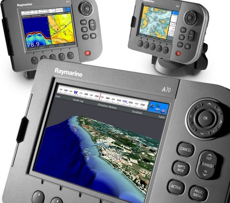
Amongst ICAST’s abundant rods and lures—even a big, lively bowl of live worms—I came across this interesting development: Raymarine previewing an impressively redesigned A-Series, previously unannounced and currently invisible on line. There will be five new models, whose names correspond to screen sizes, sort of. When the series truly debuts in October, we’ll see a 5" A50d, a 5.7" A57d, and a 6.4" A70d (hey, the C70 is actually 6.4" too), all with HD fishfinders built in (unlike the superseded models), plus A50 and A70 plotter-only versions.
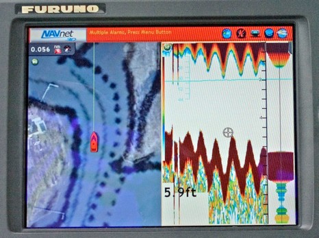
That’s a strange, but very impressive fishfinder scroll on the NavNet 3D MFD8 above, and bigger here. You see, Furuno claims that its new SC-30 satellite compass is so sensitive to a vessel’s altitude, which really only changes as it heaves up and down in seas, that NN3D can use that input to remove heave error from its fishfinder screen. I was pretty skeptical about that claim until the end of my NN3D cruise off Cape Cod, when Iker Pryzo uninstalled the SC-30 and showed us how simply pumping it up and down a couple of feet—shown below—registered immediately on the screen above. If it can respond to small, quick movements like that, it can surely detect swells and likely also compensate for pitch and roll, and thus stabilize side scanning sonar. Amazing!
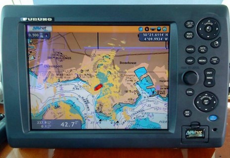
Last week I got another brief look at Slancha’s Garmin 18” HD radar in action, only this time I got this screen shot showing its MARPA abilities in action, bigger here . But I’m still a bit puzzled about the implementation, and, as noted in the earlier entry on this unit, can’t find a thing about it in the manual. My guess is that the projected point and time represent the calculated CPA relative to your boat, not relative to the chart. Let’s consider the top right target first, and note that the arc represents where Slancha could be in 3 minutes at this speed. CPA, of course, is figured on the current speed and heading of your boat and the target. So I think that the Garmin is telling us that in 1 minute and 13 seconds the target will be a close as it’s going to and it will be broad on the starboard bow (but when this takes place we’ll be nearing that next bathy line and the target will be near that 11’ bump).
The good news is that more Furuno NavNet 3D MFDs are getting delivered and installed; the bad news is that some of the first users aren’t happy with the charts, neither the rasters nor the vectors. For instance, the two empty MFD12 holes we saw a while back are finally filled, but now the owner—Hull Truth poster “PSW”—is wishing he could use Navionics cards in his MFD12s, as are fellow posters “srmote” and “snowpup”. And I know that our own frequent poster Russ was not pleased with his first look at the charts on his MFD8. My own NN3D experience off Cape Cod did not leave me nearly as negative, but I did note some weaknesses. It helps that I like raster charts and am used to plotting on them, but I didn’t think they worked very well on the 8” display, as suggested in the screen above. Some other levels of zoom/chart scale looked better, and some worse. 3D perspective can put more info on the screen—and fast panning/zooming make it all more tolerable—but there’s just no getting around the fact that you’re looking at a large paper chart through an 8” window. The rasters looked fine to me on the 15” display that was also on the test boat, and I’d guess they’d work OK at 12” (but the Hull Truth gang don’t seem to think so).
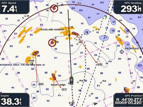
My first time out with the Garmin 18” HD radar was a bit disappointing; Rockland Harbor (try the ‘NOAA’ slider), loaded with bold shore features and boats, seemed overloaded with blotchy targets. It didn’t help that I’d recently been out in another small boat with a Furuno 3.5’ UHD open array that painted targets with astonishing accuracy, even without adjustments. But that’s not a fair comparison (aside from the 4x price difference); the GMR 18” HD, like most any scanner this size, has a 5 degree beam width, while the 3.5’ one has a beam width of 2.3 degrees. I don’t fully understand the transceiver physics, but this ratio of scanner width to target resolution is pretty much immutable in current marine radar technology, and it really makes a difference.
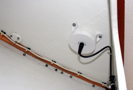
Today was my second in a week out on Peter Smith’s Banks Cove 22 Slancha, and I’m ever more impressed with Garmin’s NMEA 2000 sensors and its 18" HD radar. Let’s start with the GPS 17x, which now ships with all 4– and 5000 series MFDs, as discussed in March. Peter chose to use the optional under-deck mount, as seen above. It’s way up in the bow of Slancha, and I’d guess that backing plate at left is under the forward starboard pulpit mount, meaning there’s some stainless steel pipe between this sensor and some satellites.
This is the collection of NMEA 2000 instruments I’ve been testing for several months, but here they’re shown in direct sun light (at about 45N latitude, but this afternoon, darn near solstice). Pop up a bigger image of the shot above to see how different they look than when in the shade of a pilot house (or electronics lab). When photographing these screens in controlled lighting I have to turn down the brightness of both the Garmin GMI 10 and the Maretron DSM 250 so they don’t blow out the others, but look what happens here, with everything at maximum brightness (or in the Furuno case, automatic brightness). The transflective Raymarine ST70 is at least on a par with the two other color screens, and the Furuno FI-50s are in a class by themselves, though I think they use the least power of the bunch.
Seeking the cutting edge of marine electronics—any technology really—can be bitter sweet. On the one hand, for instance, it’s wicked hard right now to actually get your hands on Furuno NavNet 3D equipment here in the States, so hard that Furuno USA just posted a long apology about it. Meanwhile a U.K. Panbo reader and electronics pro has just installed a full suite of NN3D gear, and is exceedingly impressed (as I was after a trip on a Furuno test boat in May):