iNavX, raster navigation on iPhones

... written for Panbo by Ben Ellison and posted on Aug 4, 2008

INavX_Camden1

On Saturday the Apple iPhone app store started offering iNavX Marine Navigation and it’s already generated eight mostly positive reviews there. The $50 program is the work of Rich Ray, who also developed GPSNavX and MacENC, and it looks similarly well done. It works with the built-in GPS of the new 3G iPhone of course, but can also be used on older iPhones using cell tower location services. Alternately you can set it up on an iPhone, or iPod Touch, to get GPS, wind info, and other data via a boat’s WiFi router and a program like MacENC (or Coastal Explorer) that can output NMEA 0183 messages to TCP/IP (Franson GPSGate should also work).

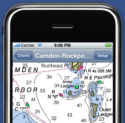
The charts are downloaded straight from the NOAA site and stored on the phone. I’ll be curious to see how easily they pan and zoom, as opposed, say, to the reprocessed raster charts offered by ActiveCaptain Mobile (which I now have up and running). You may recall that NOAA raster charts are experiencing an “update interruption”, but at this point they’re still the most current charts you can get, I think. And note that while this screen shot makes it look like I’ve got the iNavX here in Camden, actually it was captured by Ray as a comparison with a recent Garmin Colorado entry. I do hope to try iNavX on someone’s iPhone and/or that some of you Panbo-reading iPhone zealots will comment on its performance. Hang on, Gram Schweikert is already on the case.

INavX_Camden2

Comments

Ben, looks like your link is broken. I have posted my initial impressions and will be following up on my blog at VofJ.blogspot.com

Posted by: ibsailn at August 4, 2008 2:56 PM | Reply

I have been using a Garmin IQue3600 which supports their Blue Charts and works super.

What I like is the panning and zoom in feature which you do with the stylus and it runs circles around the clumsy Raymarine C80. For one you can zoom in to where you draw the marquee and at an zoom scale, not the fixed one's on the fixed mount plotters. This and the fast panning make moving around the chart much better than the rocker panel approach and fixed zoom scales.

I don't use waypoints or routes so this little guy is just showing me where I am and where I am heading (infinite course line). It does leave breadcrumb tracks which is nifty too and does the calcs in knots and nautical miles.

The IQue screen is very bright and readable in sunlight or dark. The downside is batt life sucks so it's on a 12v power chord.

It's handy!

Posted by: DefJef at August 4, 2008 9:35 PM | Reply

Yes, but can your IQue 3600 take a call, play music, or take a picture? Actually the IQue looks like a nice solution. How often does Garmin update the proprietary format Blue Charts? And how long is the lag after NOAA updates them? Can the IQue repeat instrument data such a wind speed or depth?


Posted by: GPSNavX at August 4, 2008 9:40 PM | Reply

I decided to get the IQue years ago when I thought a PDA made sense. I could carry all my contacts and a calendar and sync it with my PC which was easier for data entry. It came with Streets and voice directions, the ability to do Blue Charts, record and store music, pictures in SD cards, plus all the usual PDA add ons like excel and word.

Never thought about using it as a phone.

I recently picked up the Samsung Instinct which is similar to the Iphone and DOES GPS streets in 3D and also shows you on a 2D street map, and does phone stuff, email, web browsing, music, pics and so forth. I took it for a spin last night and it has a traffic feature which looks ahead and gives you an alternative if there is traffic.

I prefer the Ique for land and sea nav and actually think a separate small flip phone makes the most sense. One device with all the web enabled features etc. and a separate one for phone that is small, inexpensive. This requires 2 numbers, but it might be the way to go for reliability and convenience. The large flat screen phones etc. are not convenience to shove in your pocket or stick on your belt.

And when a single device fails, you are in deep doo.

Posted by: DefJef at August 5, 2008 7:11 AM | Reply

Welcome iNavX. Seriously.

Welcome to the most exciting segment of the computer industry - mobile phones.

And congratulations on your first mobile phone software product.

Putting real navigation power in the hands of boaters around the world will make their experience safer, more enjoyable, and richer. It's happening already.

We look forward to responsible competition in the effort to distribute this technology to the world. And we appreciate the magnitude of your commitment.

Welcome to that task.

Jeffrey Siegel
President
Active Corporation
www.activecaptain.com

Posted by: Jeffrey Siegel at August 5, 2008 8:59 AM | Reply

The IPhone is appealing. Unfortunately, AT&T and their sub-par network in this area and the inability to change batteries are major issues for me.

Posted by: Looutout Sailors at August 6, 2008 8:19 AM | Reply

I have posted a Day 1 review from using iNavX last night's Jamestown PHRF race on my blog (linked via my name below). Built in GPS performance is a bit disappointing (not the developers fault) and although not as bad as I would have thought, I still want to be able to zoom out further. Battery life and other data in the post. More will follow after the weekend on Visions of Johanna

Posted by: ibsailn at August 6, 2008 11:08 AM | Reply

Gram (aka ibsailin) is really giving iNavX a work out:

http://tinyurl.com/6la7l5

Posted by: Ben at August 11, 2008 8:01 PM | Reply

Can the iNavX Marine Navigation overlay NOAA Radar images on the chart? An application that could download NOAA radar and plot your position relative to the radar chart via the internal GPS would be incredibly useful! I really don't need the radar overlaid on top of a nautical chart, but it would be a bonus. I would just like to see my position, relative to storm cells. If that software existed, and used NOAA radar images (so there is no monthly charge for using the software) I would get in line for an iPhone today. I would rather pull out my iPhone and check my position on radar, then pay for Serius or XM weather, and have it on my plotter. On my iPhone, I could use it in the car, at the game, in the woods. Not just in my boat.

Posted by: Bob Mueller at August 13, 2008 1:46 PM | Reply

iNavX does not currently have a Radar Overlay option. I know that the developer is looking to add grib weather overlay soon. There are other options for viewing radar on the iphone. I use weatherbug which is free, but does not plot your position. Still, you can get your position in google maps (if you really don't know where you are), then open weatherbug to see the weather. I havn't found any radar systems where you can zoom in far enough to have your exact position matter.

Posted by: ibsailn at August 14, 2008 12:51 PM | Reply

iNavX 1.0.2 is now available on the iPhone app store. Chart zooming from 5% to 100% is now supported in addition to plotting of AIS targets.

Posted by: GPSNavX at August 25, 2008 11:08 PM | Reply

Version 1.0.2 just came out tonight and adds the overview zoom that I have been looking for. View my link below to see my iNavX posts including how handy I found the program during my cruise last week.

Posted by: ibsailn at August 25, 2008 11:24 PM | Reply

Leave a comment