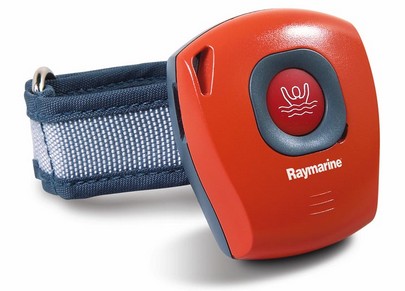
Raymarine needs a copy editor (Panbo does too!), but otherwise this sneak peek page has a lot going for it. Sirius Satellite Weather is happening on the E Series; C & E get AIS plotting, plus better data and NMEA 2000 engine displays; and the technology under the new 18” and 23” radomes sounds very interesting indeed. Raymarine is also introducing an active RF LifeTag man overboard system. Up to 16 crew members wear the gizmo above and a system-wide SeaTalk alarm will go off if a wearer gets too far from the receiver, or if he/she pushes that button.
PS. I often use Google to check spelling and/or word usage, and am dumbfounded to find millions of “sneak peak” in use, including ABC and PBS. Wouldn’t that “sneak peak” be “the top of a hill or mountain ending in a point” that’s also “carried out in a clandestine manner”? Am I missing something here?
My head hurts! I’ve got 11 ECS packages installed here now, and I’ve been fooling with them on two computers for the last several days. Would you be surprised to hear that Windows XP has occasionally crashed, sometimes violently, and not everything plays together nicely? Like when I start Nobeltec Admiral 8.1, MaxSea 12.2 also tries to start! I have the two computers connected with a null serial cable, meaning I can run NemaTalker (a great utility from SailSoft) on either one and an ECS running on the other thinks it hears, say, the virtual GPS above, which I control, plus a sounder, compass, etc.. In other words, I can ‘drive’ the boat on one screen, and plot the results on another. It’s geek fun for sure and a better way to test an ECS than with its built-in simulator/DR function. Unfortunately NemaTalker (full screen here) does not send AIS targets, and there aren’t many where I live, but one ECS provides its own test AIS in a very interesting way, explained tomorrow.
A French software company called Just Magic has created some neat Google Earth placemark files (.kmz) and has links to others of nautical interest. That’s part of a NOAA chart above (slow loading as you might expect) plus links to world wide XTide tide stations and bouy weather stations (you can click and go to predictions in both cases). And here’s a page that uses Google Earth to track the Volvo race. Will we be navigating on GE eventually?
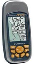
Woot sells one product a day, either until it’s sold out or the next day comes along. Shipping is always $5, and the sales pitch is usually a riot. Today’s deal is a Lowrance iFinder handheld mapping GPS, similar to the one I’ve been trying, for $140. Good machine, excellent price I think.
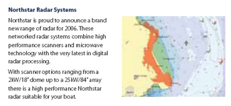
The Northstar 8000i will get a lot of attention in Miami. In fact, I just scratched the surface when I profiled its touch screen technology and overall architecture in early January. For instance, I didn’t mention the radar scanners, which are entirely new. The hardware is from JRC, the software from Northstar [correction: Northstar also designed the processor hardware], and I’m told that the results are amazing. At any rate, a British company has just put up the Northstar 2006 catalog, which has the best material I’ve seen yet on the 8000i. It’s a 3 meg .pdf file here.
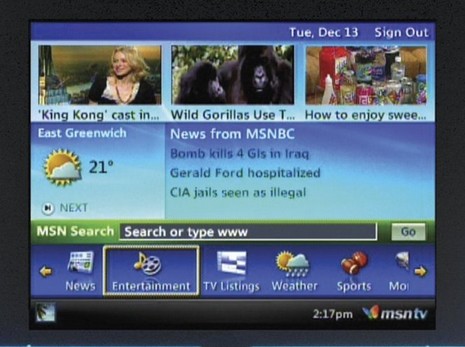
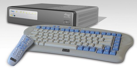
The Miami Boat Show is next week and the new product teasers are coming in fast and furious. How about a KVH cellular modem combined with MSN TV, which is an Internet appliance and portal meant to be used with a TV screen? Yup, it’s the old WebTV (which served my dear mom well for a while), but now in its second incarnation…faster, more able, etc. This wireless unit promises DSL speeds using EVDO cellular data and 50 to 80 Kbps using the more pervasive 1xRTT. The concept was actually announced at CES in early January, but the marine version will be detailed in Miami. It appears to be a simple product that might please a lot of boaters looking for easy Web and e-mail. And whereas the box also becomes a WiFi hotspot, it may even have geek appeal. More information, hopefully including hardware and subscription costs, after Miami.
You’ve gotta admire John Williams’ keep-the-costs-down / keep-the-battery-full / let’s-go-sailing philosophy. The pride of his nav station (bigger here) is this antique (Windows 95), 12v sipping, pen computer (eBay, $50) which has a Holux PCMCIA GPS card (eBay, $55) plugged into it at left, and is running SeaClear charting software and NOAA raster charts (both free). John’s blog pictures the setup here and details it here, (and don’t miss his experiments with LED replacement bulbs here). This guy is having a lot of fun with a 25–year-old sailboat and some cast off electronics, though he does admit to desiring one of these. Thanks, John!
Geez, yesterday’s request brought in some wonderful feedback about charting programs, not to mention some good material for future Panbo entries and even a candidate for my Helm Shot column (if he’s not too shy). This blog is helping me with my day job as a magazine writer, and it’s a delight to make contact with such interesting readers. But what really tickles me is that Panbo may play a small role in improving marine electronics and software. The latest evidence is the way RosePoint modified Coastal Explorer so that ENCs will always display those rocks we’ve been worrying about lately (even though, for reasons unknown, that’s contrary to the ECDIS standard). Gregg from RosePoint exclaimed the issue nicely in comments yesterday, and later a reader pointed me to a thread at Trawlers-and-Trawling which suggests that the customer who motivated RosePoint referenced Panbo. At any rate, hat’s off to RosePoint for responding with amazing speed.
And so let’s complain when we see a problem. Below, for instance, is Fugawi’s ENC display of Camden Harbor. Fugawi already has the rocks right; no matter what display options you pick (full screen shot here), you can not make them disappear. But, damn, why can’t they get the depth soundings right? What is 9subscript8 feet anyway? 9’8” or 9 and 8/10ths feet? And who cares…10 is what the original says and that will do just fine. These messed up soundings take up precious screen room and confuse the eye and brain (and I’ve seen the same problem on other vector chart displays).
PS. I’m aware that all charts will supposedly go metric eventually, and that the underlying soundings in the ENCs may already be in metric, but note how some ENC screens below display feet in nice natural numbers.
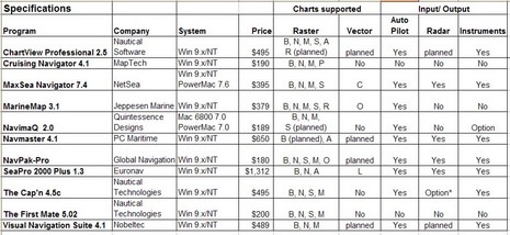
I was so wet behind the ears! One my first attempts at magazine writing was an overview of Electronic Charting Systems (ECS) for the Sept/Oct 1999 issue of Ocean Navigator. I spent months doing the research, actually installing and testing all eleven programs above (table bigger here), and wrote some 11,000 words on the subject. I recall that ON was surprised at the size of it, but published almost the whole thing (some is still online, titled "Power navigation", though you’ll need a subscription to read it).
At any rate—though I’ve tried to avoid big overview articles, particularly about ECS, ever since—I’m about to write one for Sail (which I’ll probably modify at some point for PMY). I’ve got to fit it in 2,000 words/six pages, and my idea is to highlight a good selection of particularly well done features, hopefully in as many different programs as possible. It goes with the idea that there is no perfect program for everyone, and that you can learn a lot about what’s possible via diligent shopping. I’d love your help. What do you think Nobeltec VNS, or Coastal Navigator, or RayTech or whatever does particularly well? And what ECS features are important to you, anyway? Please post ideas in the comments or just e-mail me. Developer comments welcome too.
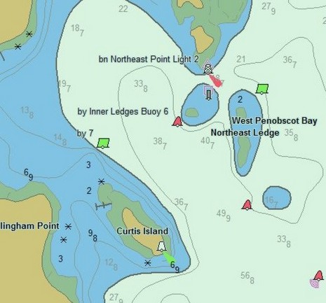
NavSim sent me a screenshot (above, and full size here ) from its latest BoatCruiser software, which now supports C-Map Max charts…and there—unlike the shot I put up yesterday—is the Curtis Island light. That got me investigating. I discovered that if I zoomed in tighter in PC Planner the light suddenly appears. So it is there in the data, though it certainly should appear in the zoom level I showed and in even larger area zooms. I also found a picture of the same Max card being used in a Standard Horizon plotter last summer (below), and the light is showing. I don’t have a C-Map compatible plotter here to see if disappears inappropriately as you zoom out. It’s nice, by the way, to be reminded of those tracks I made last season.

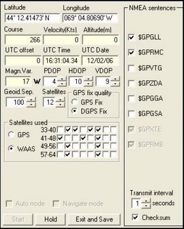 My head hurts! I’ve got 11 ECS packages installed here now, and I’ve been fooling with them on two computers for the last several days. Would you be surprised to hear that Windows XP has occasionally crashed, sometimes violently, and not everything plays together nicely? Like when I start Nobeltec Admiral 8.1, MaxSea 12.2 also tries to start! I have the two computers connected with a null serial cable, meaning I can run
 Woot
Woot