Geez, I’ve got companies (and individuals) sending me screenshots to prove that their charts show the rocks in my harbor! That’s Garmin BlueChart on a PC above. You’ll notice it’s based on the 1:20,000 harbor chart, like the NauticPath I first showed, only the obstructions are clearly marked. (Garmin seems particularly big on this obstruction symbol, keeping them onscreen even as you zoom out). More good news: the rocks also show clearly on Navionics’ and C-Map’s vector charts, and on NOAA ENCs as displayed by Nobeltec and Fugawi, neither of which will even let you turn them off. Dennis Mills, developer of the very able Capn, told me the reason that some software, including his, can turn off the rocks is screwy but official S57/ENC object prioritization. But then, doh!, I discovered that the Capn is not showing the obstructions that cover symbol on at least some of the SoftChart style ENCs it uses, even when in the well-described “Full Navigation Info” mode. Mills was surprised, blamed the software they use to create the ENCs from the NOAA raw data, and signed off “we’re working on it!” I think MacENC is also working on making its rock display more conventional.
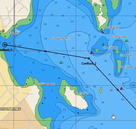
At any rate, I think we should all take a careful look at the different electronic chart types we use, perhaps especially the ENCs. Look hard, and send me examples of important details that are missing or badly presented. I doubt that anyone is tracing the paper charts perfectly, and even the paper charts have errors. For more inspiration, check out this C-Map Max image of Camden Harbor. It’s one of the nicest vector displays I’ve seen, and the rocks are right…but where the hell is the Curtis Island Light, the biggest navigation aid in the area? Doh! Have a nice weekend, but don’t completely trust any chart.
You’d think I’d know more about this than I actually do! Apparently Voyaging Magazine—for which I write a column called Helm Shot (only the first one is online, unfortunately)—is running a ‘makeover’ style contest in which the winner will get a whole Furuno NavNet vx2 electronics system installed in his or her boat. Nice! Now Voyaging (created by PMY) is about powerboat cruising, so you have to own that sort of boat. Then you need to take some decent pictures of your current setup and write an essay of up to 1,200 words describing it and explaining “how winning brand-new Furuno equipment would improve your cruising lifestyle.” The winner will be chosen by a panel of Voyaging and Furuno experts (including me) “based on the creativity and originality of the essay and photographs entered.” I’m sure Voyaging and Furuno will do a lot of promotion about this contest (which ends in June), but how many folks will actually enter? Sounds like an opportunity.
If, on the other hand, you’ve already put together a cruising power boat electronics package that you are particularly proud of, maybe you’d let me profile it and you for Voyaging. There’s no prize, except for a few free copies, but it is fun. Write me.
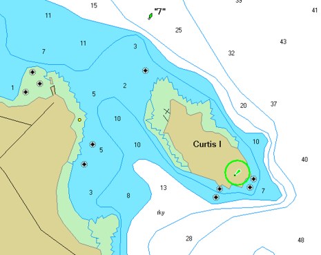
Panbo friend Jeffrey Siegel sent over an excellent example of how important those chart asterisks can be. His raster chart clip above “shows a very nasty rock just outside Castine that is exposed by two feet at low tide (and thereby lurking just out of sight for most of the day). I know of 10 boats that have hit this rock - one guy even installed a pole on it after hitting it because he was so angry (it has since fallen off). It would be completely unacceptable to have that rock missing on any chart.” Well, I’m sorry to report that this “obstruction that covers” (official NOAA designation) is completely missing from the NauticPath charts I’m testing. Query the area with the cursor and it shows a minimum depth of 12’. Not good!
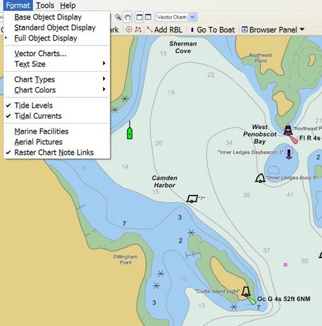
Moreover I’ve come to realize that NOAA’s own ENC vector format can be a little dicey about showing these same obstructions. There is no detailed ENC for Castine yet, but when I open the Camden 1:40,000 chart in Chart Navigator Pro (aka Coastal Explorer), the obstructions only show if I’ve set the ENC format to “Full Object Display”.
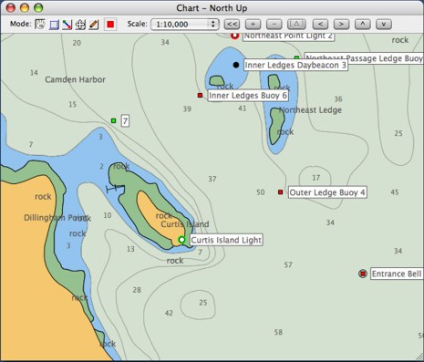
Then there’s MacENC, whose developer has for some reason chosen to show the obstructions by writing out “rock” instead of using the common symbol. I find that confusing as such words usually describe bottom composition, plus the point location of the rock is lost. At any rate, I’m going to check out how some other programs display the ENCs, and how other vector formats handle the obstructions, but right now I’m feeling very fond of familiar raster charts!