
"Obstructions that cover", there's more
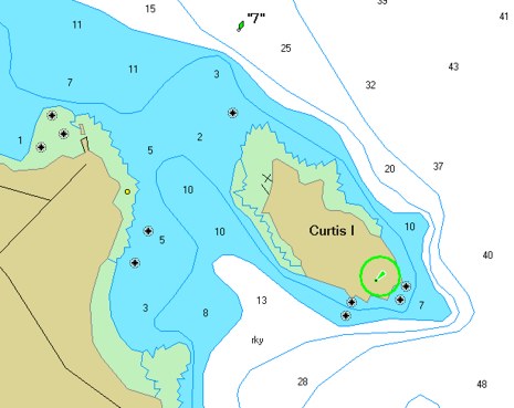
Geez, I’ve got companies (and individuals) sending me screenshots to prove that their charts show the rocks in my harbor! That’s Garmin BlueChart on a PC above. You’ll notice it’s based on the 1:20,000 harbor chart, like the NauticPath I first showed, only the obstructions are clearly marked. (Garmin seems particularly big on this obstruction symbol, keeping them onscreen even as you zoom out). More good news: the rocks also show clearly on Navionics’ and C-Map’s vector charts, and on NOAA ENCs as displayed by Nobeltec and Fugawi, neither of which will even let you turn them off. Dennis Mills, developer of the very able Capn, told me the reason that some software, including his, can turn off the rocks is screwy but official S57/ENC object prioritization. But then, doh!, I discovered that the Capn is not showing the obstructions that cover symbol on at least some of the SoftChart style ENCs it uses, even when in the well-described “Full Navigation Info” mode. Mills was surprised, blamed the software they use to create the ENCs from the NOAA raw data, and signed off “we’re working on it!” I think MacENC is also working on making its rock display more conventional.
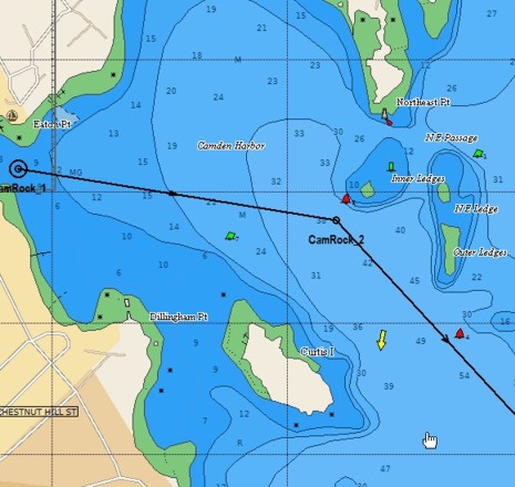
At any rate, I think we should all take a careful look at the different electronic chart types we use, perhaps especially the ENCs. Look hard, and send me examples of important details that are missing or badly presented. I doubt that anyone is tracing the paper charts perfectly, and even the paper charts have errors. For more inspiration, check out this C-Map Max image of Camden Harbor. It’s one of the nicest vector displays I’ve seen, and the rocks are right…but where the hell is the Curtis Island Light, the biggest navigation aid in the area? Doh! Have a nice weekend, but don’t completely trust any chart.
Problem is (in this case), the S-57 ENC data the rock is not tagged as an obstruction (most are) but instead as "nature of surface" (i.e. what's the composition of the sea bottom). MacENC uses text to render the nature of surface (i.e. mud, sand, rock, gravel, grass, etc).
So it is an easy change to make the assumption that any rock that is in shallow water is also an obstruction and as such be rendered with the normal (*) graphic. The downside is that it may not actually be an obstruction, but instead just a rocky bottom.
As noted before the S-57 ENC specification does not make rules in regards how to render features. Only when features should be rendered are specified.