How do they do that? The new JRC JLN-550 Speed Log at right is displaying not just 18k of forward speed over the ground (SOG), but is also showing that the bow is going to starboard at 1.8k and the stern to port at the same speed. The trick starts with a 4 beam 240 khz sonar transducer in the bow. The doppler shifting of the sonar pings off the bottom is used to get two axis SOG. The third axis (the stern motion) is calculated by adding rate-of-turn input from a gyro or ROT capable electronic compass. When bottom depths exceed 250 meters, the unit can switch to speed through the water (STW) using ultrasonics (2 mhz) to measure passing particles. Now this is big ship gear for sure—it starts at about $26,000, and the 265 pound transducer is termed “compact”—but accurate STW underway and multi axis SOG around docks would be very useful on medium size boats too. I’m hopeful. Airmar already has an ultrasonic speed transducer scaled for yachts (pdf brochure here). Now we just need a small, reasonably priced 4 beam sonar transducer.
Once again the Maine Boats and Harbors show was a great chance to rejoice over how healthy boatbuilding is in my state, and to see some interesting electronics setups. This is a high end Sequin 52 built by Lyman Morse. I really like how the helmsman gets fingertip control over most everything, but the crew can also see what’s going on and easily help with the navigation. Left to right on the pedestal (bigger picture here) are a Maxwell windlass control, a remote for the Raymarine ST290 graphic instrument displays over the companionway (which can show most anything), plotter/radar on center, and finally thruster and autopilot controls. The big HSB networked display (now superceded by the E series) under the dodger means someone can, say, mind the radar in fog, selecting MARPA targets and otherwise assisting the driver. And there’s another 10” down at the nav station, so someone else could be, say, working on a route. All three could be using the electronics independently, except for sharing a single radar range, and everyone on board can know where they are on the chart, boat and wind speed, etc. Fairweather (good pictures there) even has an ST290 display mounted in the overhead above the owner’s berth, the modern version of a telltale compass. Looks like A+ ergonomics to me.
If you have a fast Internet connection, you also have a zillion good weather resources at hand. I wouldn’t dare to say which are best. But one I’ve gravitated to over the years—even paid a tiny subscription fee to—is the Weather Underground. I think it started as a university science project, which may account for the name referencing a really desperate and counter productive 60’s political movement. Whatever, it’s great. The screen shot at right (bigger here) shows how you can zoom in on a NEXRAD radar animation which you can also customize to your taste. Wunderground now even identifies storm cells, which I’d only seen before on the high end satellite products from XM and The Weather Channel Marine. But it was interesting yesterday when that cell shown over Penobscot Bay sprung up right over my house. 12 minutes earlier it didn’t show on NEXRAD at all. In other words even the fanciest tools couldn’t have kept you out of the way. The front did clear the air though, making for a great first day of the Maine Boats & Harbors show in Rockland, which is where I’m headed. Have a wonderful weekend!
It was just last week that Rich Ray sent me this screenshot of MacENC, a new version of his GPSNavX charting program that supports NOAA’s free ENC vector charts. But after Tuesday’s news about free raster charts, it no longer seems like a big deal. Now we know that by about next spring Rich and other developers will probably be able to sell their charting software on a DVD that includes the digital equivalent of every single NOAA U.S. paper chart, without any encryption hassels and at little added cost. And users will be able to update those charts weekly if they want (making that easy will be another chance for developers to add value). But ENCs aren’t going away. They’re better than RNCs in many ways, and they’re definitely the future. Eventually—when ENCs are perfected and coverage complete—NOAA will drop raster chart production altogether, even printing paper charts from the vector database (if they print charts at all). Right now it’s quite useful to have both RNCs and ENCs for the same area; each has data or display features that the other lacks. In fact, if I was a Mac person, I wouldn’t think twice about paying the extra $35 for MacENC. I’m looking forward to inexpensive DVDs loaded with both types of free U.S. charts.
By the way, breaking the raster story generated a record number of readers here at Panbo, and for a moment made me feel like Matt Drudge (in a good way). A big thanks to whoever it was out there e-mailing Panbo links all over the planet!
I’m a long time fan of the PDA charting program Memory Map, which is also sold as Maptech Pocket Navigator, and think that its developer, Richard Stephens, is one hell of a programmer. It’s no great surprise then that Richard has mastered mini PC navigation, even while overnight racing aboard a wickedly wet Corsair 28R trimaran (In fact, it was so wet, at one point we had a 2’ long fish flapping around in the cockpit!). But it’s good to know that a coder is out there getting his butt soggy (getting to be one of my favorite blogs), and it surely is interesting to hear about his set up:
I used a PDA for navigation (of course). Itwas connected by Bluetooth to a GPS and to a cell phone in the cabin, which was in turn connected to a Digital Antenna signal booster and 4' antenna. The PDA was an iPaq 4700, in a Otterbox 1900 hard case. I wear the PDA most of the time, strapped to my body with bungee cord (under my PFD belt so it does not flap around). It is turned off when I am not actively navigating, to save power. I also wear a Garmin Foretrex on my wrist, programmed with the route and strategic waypoints [using Memory Map either on the PDA or a PC].
The PDA runs Memory-Map for navigation, using the full detail of NOAA raster charts, with all weekly NTM corrections applied. I used the cellular internet connection to access weather information from NOAA. The real-time buoy/weather station reports, weather radar images, and the ETA wind model. were all extremely useful at different stages of the race. All of these were accessed just using the web browser on the PDA.
Richard and the rest of the Flight Simulator team won first in class in their latest race, the Mackinac. How geek cool is that?
Wow! The CRADA (Cooperative Research and Development Agreement) that made Maptech the only official source of NOAA Raster Navigation Charts (RNCs, like the snip above, which are like paper charts) is over, and the new plan sounds terrific. Maptech will continue to use its expertise to produce/update the RNCs, but will deliver them weekly, in unencrypted .bsb format, to the Office of Coast Survey (OCS), who will distribute them over the Web. Anyone will be able to download them for free, including commercial vendors who can encrypt, add value, and repackage them (within certain guidelines). While this development has been rumored about for some time, this is now the official word from OCS, though “No date has been set by which this distribution of free raster charts will begin.” A free portfolio of U.S. RNCs—which, unlike the ENCs, is complete—will really stimulate PC and Mac charting programs and I think has already motivated some of the price slashing and big value adds in the vector chart segment (just check out the “charts” section of Panbo). Above all, I suspect it means that eventually just about every salt water boat in America will have some sort of plotting device aboard. Hats off to NOAA, and let’s hope that some the world’s other hydrographic offices follow its lead (don’t hold your breath).
Update, 8/10: I’m getting questions about how “official” this news really is. My source is a fairly formal e-mail sent by OCS to a developer. It seems quite genuine and clearly states what I wrote above. But please note the one sentence I directly quoted; we do not yet know when this will happen.
Update 2, 8/10: Another developer I know called OCS and spoke with the gentleman who heads up the RNC division. He verified the above and also said that their goal is to have all RNCs online by the end of this year, if not sooner.
Update, 8/11: Alright already! I finally did what a better (and less busy) reporter might have done in the first place; I spoke directly with the Public Affairs Officer at OCS. He verified this story completely, but said that NOAA didn’t plan an announcement until free downloading is immanent. So, no, you won’t find this on an official Web site, but, yes, it is official.
I was a little stunned this morning to discover two very interesting and ambitious marine weather services that seem to have sprung up fully formed, but without my knowledge! SailFlow and FishWeather are sister services, each offering tailored weather products either graphically via the Web or a WAP enabled cell phone (there are lots), or via a regular voice call. The services boast their own weather sensors covering a lot of the U.S. coastline, plus their own meteorologists and even computer modeling programs (in addition to public resources, of course). It turns out that both are the spawn of WeatherFlow, a company which has spent 15 years building a “national coastal mesonet with a presence in over 20 states…The WeatherFlow staff of engineers, meteorologists, and IT professionals are dedicated to increasing the understanding of the complex nature of climate within the coastal zone.” I intend to try out at least each service’s free month trial Web subscription. By the way, Eli of EliBoat—whom I had the pleasure of meeting last week—has been using WSI live satellite weather, which is a whole other animal than SailFlow. He posted some comments yesterday.
I was pleased to get an automated e-mail from Boat U.S. last week reminding me to update the registration info associated with the MMSI number I got through its Web site a couple of years back. It’s really important to keep this data current as the rescue authorities will use it if you ever make a DSC distress call with your VHF (or SSB) radio. Bad info can lead to wasted rescue resources, or worse. I haven’t moved or changed phone numbers, but adding more alternate numbers was easy, as was getting the free number in the first place. If you are one of the many who have a DSC radio but still haven’t gotten an MMSI number, for goodness sake do it! While it’s true that the U.S.C.G. hasn’t fully enabled its DSC listening system yet, it’s very likely that someone will hear you if you hold down that red button. Note that if you plan to take your boat outside the U.S. you should get your MMSI from the FCC, along with the needed VHF and other radio licenses. Otherwise, your MMSI will not be added to the international database. Tim Hasson of Marine Computer Systems has some good information about that whole FCC process here.
Another contender in the safety category of the MAATS innovation awards—the one that I think should have won—was Mustang Survival’s vest PFD with LIFT. I say this because last summer I tested the vest, then in developement, along with 7 other top quality inflatable suspender and belt style PFDs, and thought it was the best by far. That’s me above, and I’m not standing on the bottom; the Mustang vest is holding my head and shoulders out of the water without any effort on my part. Plus it was more comfortable than the suspender types out of the water, uninflated, and significantly more comfortable than all the other models in the water. The latter is a big deal if you’re trying to keep your mouth out of the waves and operate “help me” gear like flares, strobes, laser lights, a PLB, and/or a handheld VHF. LIFT (Life-saving Inflatable Flotation Technology) costs more than other inflatable PFDs, but it’s a truly innovative design and could make a difference. I wrote the testing up for the Nov. 2004 Sail, unfortunately not online. By the way, some August vacationers at a local swimming hole were amused as I donned full foul weather gear, then repeatedly jumped off a rock and “blew up” as Jamie took notes and snapped pictures. Some fun.
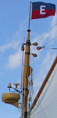
That’s Elizabeth Meyer driving her ‘new’ 1916 Lawley yawl to a finish line off Camden yesterday afternoon. I saw this boat at Brooklin Boat Yard 4 years ago, when it looked like it might disintegrate if someone sneezed too hard. The complete (every stick of wood) restoration, just finished, included adding some modern electronics, as subtly as possible. Notice how the antennas—radar, VHF, GPS, and Iridium (I think)—have all been painted to blend with the mizzen mast. Actually, painting out logos is an affectation I see on lots of high end and/or classic yachts. Quite understandably I think. I wear logo shirts all the time, either for work or because they were free, but if I ever own a really good looking boat, I’ll be damned if it’s going to be an electronics billboard. Maybe some manufacturers will consider making the logos optional? By the way, Eli of Eli Boat, was racing too; I missed him at the finish but hope to learn more about the snazzy electronics he was using.

 How do they do that? The new JRC JLN-550 Speed Log at right is displaying not just 18k of forward speed over the ground (SOG), but is also showing that the bow is going to starboard at 1.8k and the stern to port at the same speed. The trick starts with a 4 beam 240 khz sonar transducer in the bow. The doppler shifting of the sonar pings off the bottom is used to get two axis SOG. The third axis (the stern motion) is calculated by adding rate-of-turn input from a gyro or ROT capable electronic compass. When bottom depths exceed 250 meters, the unit can switch to speed through the water (STW) using ultrasonics (2 mhz) to measure passing particles. Now this is big ship gear for sure—it starts at about $26,000, and the 265 pound transducer is termed “compact”—but accurate STW underway and multi axis SOG around docks would be very useful on medium size boats too. I’m hopeful. Airmar already has an ultrasonic speed transducer scaled for yachts (pdf brochure here). Now we just need a small, reasonably priced 4 beam sonar transducer.
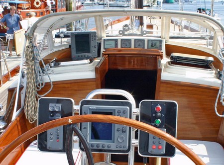
 If you have a fast Internet connection, you also have a zillion good weather resources at hand. I wouldn’t dare to say which are best. But one I’ve gravitated to over the years—even paid a tiny subscription fee to—is the Weather
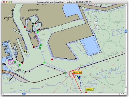
 I’m a long time fan of the PDA charting program
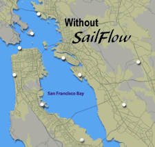 I was a little stunned this morning to discover two very interesting and ambitious marine weather services that seem to have sprung up fully formed, but without my knowledge!
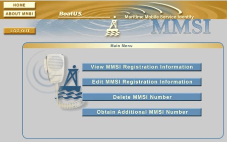

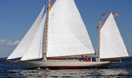
 I saw this boat at Brooklin Boat