I tested a Garmin 276C last year, and it’s an excellent little chart plotter, and also quite adept at street navigation (screen selection, distance and speed units, and routing style all switch over with a single button push). The screen is very bright and very fast. In fact, it was one of my five “editor’s picks” for 2004 in Sail magazine. Now the 376C adds XM weather and audio, making this unit far and away the most unique portable on the market. You can even plug in a blackbox fishfinder. I also tried an early version of Garmin’s Network system, which included XM weather and radio. The interface to all this info was a little clunky, but I understand that it’s been vastly improved. Which I imagine we’ll see in the 376C. And the network's fairly large receiver and separate antenna have been reduced to the petite GXM 30 smart antenna shown above. The 376C retails for a grand, but you really could carry it, along with your subscriptions to XM weather and radio, from boat to car to home. Neato! (But do note that it does not include all U.S. charts, like the new 192C). Here's a higher res version of the image at top, showing some of XM weather’s rich data. Note the storm cell predictions and lightning tracking (which is 5 minutes fresh and extends 300 miles off the U.S. coast). And here’s a column I wrote about the Garmin phenomenon last year.
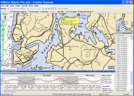
Rosepoint Navigation’s Coastal Explorer is now in “open Beta”, meaning it’s essentially done and available for download by all registered 1.0 users. The retail version should be coming along soon. The “1.1” tag is dry humor; there are so many major additions to the program that they could justify a jump to 5.0 or beyond if they felt like it. At any rate, above (bigger here) is an example of the new tides and current prediction functions. They are extremely well done; you can easily animate multiple onscreen tide and current stations and/or get graphic, tabular, or text info for any one station. Bravo!
I chose the particular area above so I could tell you something about coastal Maine, and the characters who live here. That light blue area (you really need to look at the full screen) is the Bagaduce River, which isn’t a river at all, but rather a long, complicated tidal bay (that extends well beyond the chart window). 10 feet of tide is trying to fill or drain that whole area every 6+ hours, hence the 2.3 kn current at the Jones Point station I’ve selected. The coast is so complex, and the prediction stations so spread out, that Maine boaters become amateur hydrographers, able to guesstimate current strength by looking at the chart and a tide table.
Mainers can also be crusty. The story goes that there was quite a contentious town meeting when that little bridge (lower right) was built. One gentlemen got up and said, “Why the hell should it cost so much; I could piss half away across there.” To which the moderator replied, “Sir, you’re out of order.” And got back: “You’re damn right I’m out of order; if I wasn’t I could piss all the way across!”
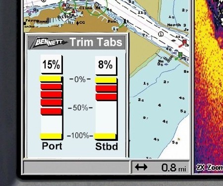
Here’s a NMEA 2000 application I hadn’t thought of, but one that makes terrific sense: the Bennett NMEA 2000 Trim Tab Interface will install easily back near the tab motors, tee into a 2000 trunk line, and send the status of the tabs to all displays on the network. Plus it will work with any of the company’s currently available tab systems (80% of US market), and it will only cost $120. I’ve been on many boats, including my own 25’ Ralph (recently back in the water), where indicators would make the tabs much easier to use, but when I’ve asked builders why they don’t install the currently available ones, they say they’re too unreliable and/or too expensive. This looks like a far better solution, and another reason why boaters and builders might move to 2000. There are two caveats, however. One is that specific displays will have to be programmed to show the tab information they are receiving. The example above is a 2000 plotter/sounder by Lowrance, which has already agreed to support Bennett’s interface. (The tab window could be more efficient—i.e., show the info well in less space—but I suspect that this is just a prototype). The second is that this product, introduced at MAATS, won’t be available until 2006. But that gives companies like Raymarine, Simrad, and Maretron time to program their displays to work with it, plus it will encourage other electronics companies, boat builders, and boaters to climb on the NMEA 2000 bus. Bennett doesn’t have information about the interface on its site yet, but there is a neat, if slightly geeky, simulator. It’s perfectly possible, by the way, to also control tabs via NMEA 2000, which would simplify installation, particularly on multi station boats, and would also enable integration of the controls with, say, Maretron’s pitch and roll sensor.

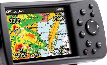
 You can even plug in a blackbox fishfinder. I also tried an early version of Garmin’s Network system, which included XM weather and radio. The interface to all this info was a little clunky, but I understand that it’s been vastly improved. Which I imagine we’ll see in the 376C. And the network's fairly large receiver and separate antenna have been reduced to the petite GXM 30 smart antenna shown above. The 376C retails for a grand, but you really could carry it, along with your subscriptions to XM weather and radio, from boat to car to home. Neato! (But do note that it does not include all U.S. charts, like the new 192C). Here's a higher res version of the image at top, showing some of XM weather’s rich data. Note the storm cell predictions and lightning tracking (which is 5 minutes fresh and extends 300 miles off the U.S. coast). And here’s a column I wrote about the Garmin phenomenon last year.
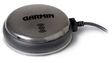