How horribly ironic! The screen above is grabbed from a USCG video showing the demolition of Alaska's tallest structure, a Loran tower that might have hosted an eLoran backup to GPS, maybe already was. Just three weeks earlier, Intelsat let it be known that it had
"lost control" of one of the two WAAS satellites, and that it would "drift out
of orbit over the next two to four weeks." And Alaska will be the place that suffers the most loss of WAAS, though all North American navigators should take note that WAAS redundancy just went away.
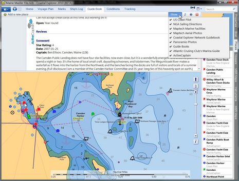
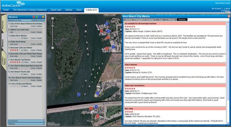
Take a good long gander at the full size screen above. That's Coastal Explorer 2010 in Guide Book mode, which already offered a wealth of port information, but as of last night (announcement here) can also show ActiveCaptain community generated info. The particular detail shown is my own enthusiastic take on our Public Landing, written when AC first launched (and still true), but notice how you can also access Atlantic Cruising Club's professional view of the facility, as well as three different angles on Wayfarer Marine and the Camden Yacht Club. The chances are good that a visiting boat can find all the information it needs in this one spot. In fact, while my entry on the neat ACC integration was titled "CE & ACC, great but not enough! Part 1," today Part 2 is pretty much irrelevant...
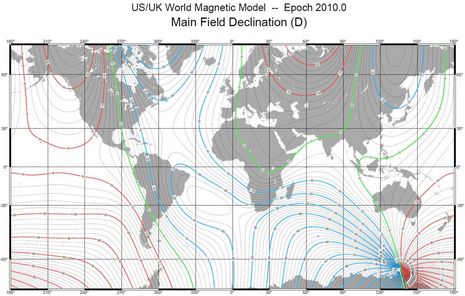
Is your boat's World Magnetic Model up to date? Does it matter? It may be a sign of Miami new product overload (here and here) that I got intrigued with this subject yesterday, but it was actually a Maretron press release (pdf here) that led the way. The company is proud that their latest GPS200 now outputs magnetic compass variation based on the latest WMM2010, and that a firmware update will bring the same precision to their existing GPS receivers. Heck, I thought GPS units just got variation from the satellites, and was reminded how much we take compass technology for granted...
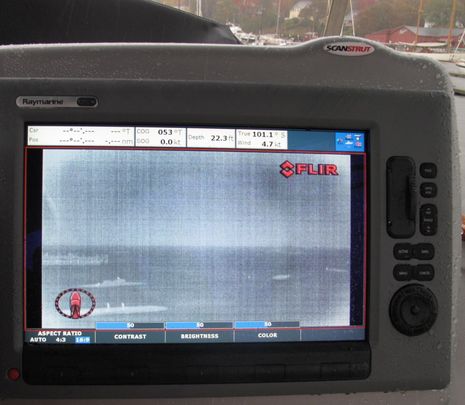
Among the new products to be shown at the Miami Boat Show next week, FLIR just announced both a lower cost fixed M-Series and two new higher-end hand-held First Mate models. The new M (no model # yet) packages a single 320x240 thermal cam with the same excellent bullet casing and Ethernet controller(s) that I tested as the M-626L last fall, with dual payload 640x480 thermal and low light cams. The purported retail of the new cam will be $12,000, which will likely mean an under 10g street price judging from some outlets for the existing models. It's great to get the price down on this valuable safety tool, but it reminds me of the occasional value I saw in also having the low light camera. The shot above was taken in daylight, but the thermal camera would have seen out the harbor as well as it does at night if it weren't for the downpour. After the break, you'll see what it missed...
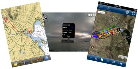
The tidal wave of interesting iPhone boating apps rolls on! The screen at left above (click for bigger) shows a beta version of Memory Map's upcoming charting app and I can tell you that it already handles NOAA raster charts and topo maps with speed and smoothness I didn't think possible on plain 3G hardware. At middle is the brand new Ships Ahoy!, a $3 AR (augmented reality) relative to Ship Finder and the other AIS viewers that lets you just point an iPhone 3Gs (you need the compass) toward a vessel or two to get their names and details (if the area is covered by a network receiver). And finally there's Navionics' neat new Ski:US, which admittedly has nothing to do with boats but does speak to this big marine company's big commitment to mobile apps. It happens to have my local Camden Snow Bowl among the so-far-limited ski area coverage, and it works great. In that screen shot I'm playing back the tracks (in yellow) I cut right after last week's big snow dump, in particular the --- MPH moment I lost board control in a huge drift. All these possibilities, and lord knows what else, will expand if Apple introduces a 4.0 version of the iPhone operating system this afternoon. But of course the bigger questions swirl around the Apple tablet, or whatever they decide to call it...
My longtime admiration for Jeff and Karen Siegel, and their creation ActiveCaptain, has started to lean dangerously toward jealousy! They've spend many months cruising from Maine to Florida and judging from their blog and the latest AC newsletter, they've not only been having fun but also writing code and making deals the whole way. Version "X" of the interactive cruising guide is really taking shape, and other developments coming soon do indeed sound "huge"...
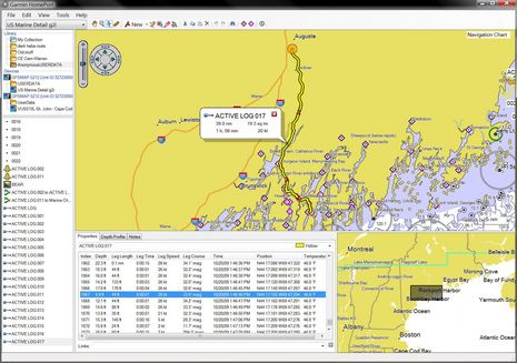
I can't imagine why anyone with a Garmin plotter, a Windows PC, and a bit of ability to use both wouldn't find Garmin Homeport more than worth the $30 charge. I was able to easily copy the 5212's embedded charts -- plus the mess of tracks, routes, and waypoints I put on it last season -- and then review/manage all on my home computer. I stowed away some memorable tracks, quickly cleaned up some extraneous waypoints (careful with that track-to-route feature), polished some favorite routes, and then overwrote the user data on the 5212 with a much more useful set. But today's look at some deeper Homeport features gets the benefit of a friend's embarrassing navigation error. Click to enlarge the screen above and I'll explain after the break...
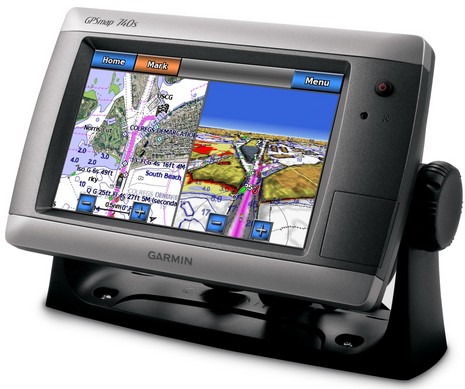
Let's see...a 7-inch, bright, WVGA-resolution touchscreen with built-in GPS and support for Garmin Ethernet radars and NMEA 2000...all at a base price of $1,400? Sounds like a sweet spot to me. I can think of many boaters who will be interested, and few comparable choices...
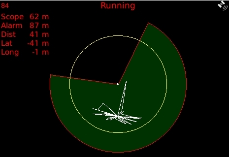
I don't think I've ever seen such a sophisticated anchor alarm, and it's an app called My Anchor Watch running on a Blackberry! (Thanks to Panbo reader Per for the head's up.) The developer's site explains the software well, but the features that really stand out for me is that "angle of exclusion" shown above and the SMS alarm capability...
Well, this may be the saddest product introduction ever. Last week CrossRate Technology finally launched its flagship eLGPS 1110 multi mode receiver. If I had one powered up outside the lab right now, I'm confident that it could use both regular Loran-C, including the eLoran enhancements already added to the system, and WAAS GPS to determine my position in two ways -- and thus redundantly -- and could also use Loran to provide heading even when stationary. But here's the giant rub: A single signature, which may come at any moment, could end Loran-C, and eLoran, in the U.S.A. for good, starting next month...