
Garmin Homeport, excellent but revealing
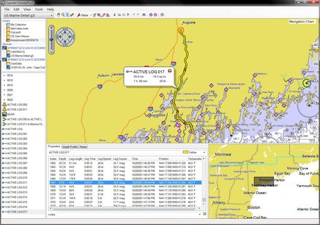
I can't imagine why anyone with a Garmin plotter, a Windows PC, and a bit of ability to use both wouldn't find Garmin Homeport more than worth the $30 charge. I was able to easily copy the 5212's embedded charts -- plus the mess of tracks, routes, and waypoints I put on it last season -- and then review/manage all on my home computer. I stowed away some memorable tracks, quickly cleaned up some extraneous waypoints (careful with that track-to-route feature), polished some favorite routes, and then overwrote the user data on the 5212 with a much more useful set. But today's look at some deeper Homeport features gets the benefit of a friend's embarrassing navigation error. Click to enlarge the screen above and I'll explain after the break...
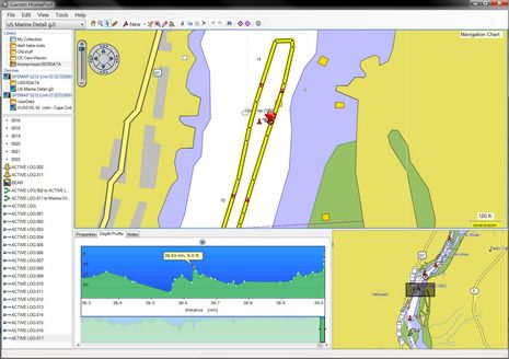
So Anon drove some 64 nm of complex river (the skinny Sasanoa is famous for its whirlpools!), and his Garmin tracked every bit of it in some detail, as you can see in the bottom middle window. Methinks it was all that navigational focus at speed that largely accounts for what went wrong at track point #1,867, when Anon was within sight of the launch ramp and running a little bit further up river to burn the gas out his outboard. Clicking once on that particular track point got Homeport to put that orange circle mark on the chart spot, clicking twice zoomed into the tragic image below.
I was with Anon when he first saw this track zoomed in on his plotter and then even better detailed on my big PC screen. "Damn!" is what he said. After running over the apparently sunken "crib" he'd had to limp the boat back to the ramp with a badly damaged lower unit and hadn't investigated the track detail. In fact, though he took responsibility in the proper captain fashion, he kinda sorta thought the Garmin had misguided him about the "Obs rep" and the correct side to leave that bouy 68a. But the log says different and actually comparing this chart to several others indicates that Garmin may have done the best job of representing the underlying NOAA data for this particular spot. Better even than the NOAA, ENC in my opinion, but I'll detail that in a future entry.
As for Homeport, note how it's able to profile the log's collected depth soundings, even zoom in on individual points and pinpoint them on the charted track. Which is pretty darn cool, though there is some discrepancy between the shallowest point marked and the actual location and depth of the crib. But, mind you, those pre-crib points were collected at 25 knots, and there may be ways to get the Garmin to record points even more frequently. (Which, incidentally are issues that will come up with data collection schemes like ARGUS.) The big story, though, is how a skipper like Anon might have used Homeport to pre run a trip like this, even route it, while sitting at home or at a down below nav station with a big screen, a mouse, and the time to really check out the chart detail available.
Ben,
Forgive me for being dense; but are you saying that Anon has an outboard powered boat that draws 9 feet at 25kts? And that this vessel is trailerable?? Is this a Macgregor or something?
What am I missing here??