DeLorme inReach gets weather & goes to Cuba
... written for Panbo by Ben Ellison and posted on Jun 21, 2016

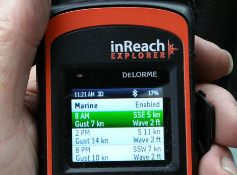
DeLorme_inReach_weather_feature_cPanbo.jpgI've long felt that the DeLorme inReach is a valuable safety and communications tool for boats that sometimes go beyond reliable cellular (and/or VHF) contact with friends, families and rescue centers. But one gripe for skippers hoping to use an inReach as their only offshore communications device was the lack of weather forecasting. There were some necessarily crude third party solutions, but now DeLorme itself is offering easy-to-use and understand forecasts, both marine and terrestrial. I've just been testing this and many other inReach features in Cuba, though the legality of taking a satellite messenger/tracker there is uncertain...
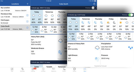
DeLorme_inReach_EarthMate_iPad_weather_feature_cPanbo.jpgThe new weather feature works with either the $300 inReach SE or the $380 Explorer model (which adds routing and high res tracking to the handheld). You can request forecasts from the handheld (instructions here), but it's easier to do with the Bluetooth-connected Earthmate iOS or Android app included with the inReach (and also now sold without hardware as Earthmate for Mobile). While I took the iPad screens above before going to Cuba, I was able to quickly pick desired forecast locations off the app's fairly detailed global map (that I downloaded for Cuba before going offline for a week). Note that the differences between the "Cuba South" and local Maine forecasts (besides the temperatures ;-). As DeLorme details here, the seven-day Premium forecast costs $1.00 while the three-day Basic is the equivalent of one text message whose cost depends on your subscription data plan.
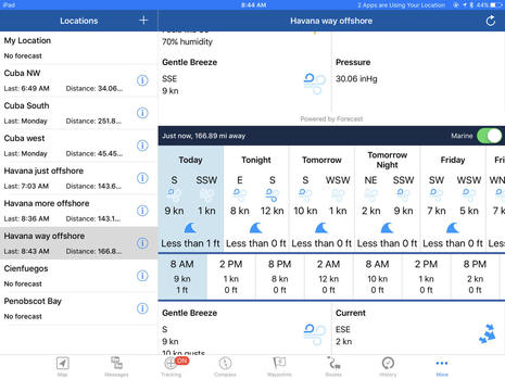
DeLorme_inReach_EarthMate_iPad_weather_feature_marine_Cuba_cPanbo.jpgThe inReach seven-day Marine forecast also costs $1 and estimates wave period and visibility as well as what's shown above. It was good to see the forecasts are sourced from long time marine weather experts OCENS, who also offer the SpotCast Weather service for inReach (and various sat phones) that I mentioned in a 2014 inReach review. There's also a free WX2inReach weather service that made a GearJunkie reviewer happy, but the third party text displays sure look limited and frumpy compared to these screens, and the reason is obvious. DeLorme can send compact binary weather data that's then made pretty by Earthmate or the inReach's firmware (which is why both have been updated for the feature).

I did encounter one issue while trying to get a marine forecast from the deck of Panorama II as we faced about 22 more hours of motoring toward Havana. The problem is suggested by the three "off Havana" forecast locations I had to create; the first two were definitely on the water but nonetheless generated a "Forecast location must be on valid body of water" error message (though no charge). "Havana way offshore" worked but was halfway to Key West, which accounts for the 2 kn current forecast that definitely wasn't true for us.

Well, it turns out that, so far, DeLorme can only generate coastal marine forecasts along the U.S. coast, so elsewhere you have to pick a location well offshore. The good news? I learned that easily by using the inReach itself to message my friend and former boatyard electronics source John Gass who happily moved to DeLorme a few years ago.
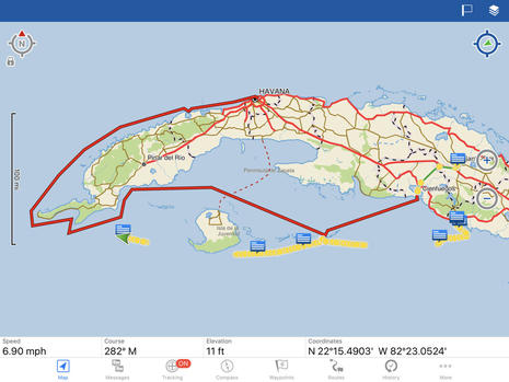
DeLorme_inReach_EarthMate_messaging_Cuba_cPanbo.jpgI also used the inReach Explorer to track much of our week of touring by boat, bus, and foot. In fact, the inReach provided the GPS needed to run five different charting apps on the iPad and, yes, there will soon be an entry about five types of digital charts available for Cuba, where the cruising looks to be fascinating. Plus, the captain of our "little" cruise ship started joking that I had better info on port arrival times than he did.
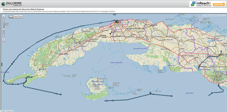
DeLorme_inReach_MapShare_Cuba_cPanbo.jpgMeanwhile, the inReach posted 10-minute track points to the PanboinReach share map I had set up in advance. While an inReach owner has lots of control of the MapShare, you can see that mine shows messages I've chosen to share and even lets a viewer locate or text me (feel free to try). The reason for the tracking gaps is that I never found a safe spot with a good sky view to leave the inReach while I was asleep in my lower deck cabin.

Then again, I was in my bunk during much of that long slog along Cuba's northwest coast, but despite my skepticism the inReach was transmitting through a porthole nearly at the waterline of a 164-foot steel vessel! Also, when you zoom into my share map, you'll see not only the larger 10 minute track points sent via satellite, but also the one-minute points collected by the Explorer model (sometimes inside a steel bus), because the Earthmate app has now had a chance to automatically sync them via WiFi.
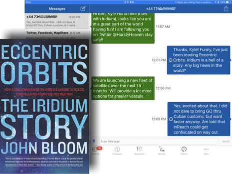
DeLorme_inReach_w_Cuba_cPanbo.jpgIridium satellite technology has always impressed me (as has the DeLorme inReach implementation), but I really had no idea of the whole story until I dug into the new book Eccentric Orbits (also on my iPad during the long trip). Wow, what a tale of tech daring, international intrigue, and business model madness. The 66-satellite constellation that was almost purposely destroyed in 2000 only had an expected five-year lifetime anyway, but they're still working quite well, at least for tracking and messaging. Notice, for instance, how quickly I'm conversing from an iPad off Cuba with a guy on his cell phone in the (+44) UK.

Now if you read the messages, you'll know that the guy works for Iridium, noticed the inReach posts on my Twitter feed, and took the opportunity to pitch me about how the new NEXT satellite system "will provide a lot more options for smaller vessels." But, hey, that sounds great, and I was hungry for any contact with the outside world. My plea for news on Twitter and on my Facebook pages did not yield much, but I realize now that most of us have a hard time realizing that someone posting on, say, Facebook may not be able to see Facebook, or even know about a horrible event like the mass murder in Orlando.

The lesson: If you really want someone to communicate with you via inReach, you probably have to train them to use the Message feature on your share map or go to the DeLorme link at the bottom of an inReach email they receive. Then again, thanks to my brother-in-law Rich, I was the guy on the boat who knew the Warriors versus Cavaliers basketball scores.
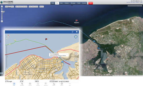
DeLorme_inReach_personal_website_Cuba_detail_cPanbo.jpgThe inset Earthmate iPad screen above shows the quality of maps DeLorme has for Cuba (and most everywhere else in the world) while the PC screen of my private inReach website shows how I can illustrate the trip with Google photo maps now that I'm home. Given that DeLorme has kindly kept me in test models since I beta tested the original inReach in 2011, I have a treasure trove of tracks, messages, and memories on that site, including both of Gizmo's round trips to the Carolinas in detail. (I've also been testing the Spot Gen3 recently, and while it's a very good satellite tracker and one-way messenger, I don't understand why a user has to use other services to save track data more than a month.)

But was it legal for me to take a DeLorme inReach into Cuba? At this point, I really don't know. Before the trip I had learned that Cuba does not allow satellite phones or even standalone GPS devices without a permit, as officially noted here. But it was also evident from many travel sites that smart phones with GPS were allowed, no problem, and that many Cuban rules are changing quickly. So it sort of made sense when a writer friend told me that I could take an inReach to Cuba like he had because it's a satellite messenger, not a satellite phone or a standalone GPS.

And I did not have a problem. I wasn't specifically asked by Cuban customs about all the electronics in my pack (unlike this poor traveler) though I did get taken aside after telling them that I had brought USB memory sticks as a donation that would be distributed to schools and similar by our Road Scholar host. The (very sweet lady) official did a double take when she saw my sack of about 40 memory sticks; two USB drives is apparently the import maximum, but she went to her boss and came back with permission for me to put them back in my bag. So the rules are odd but flexible, and once the Cubans delete the old marine electronics press releases those USB drives may be very useful.

However, the inReach could have been confiscated with return uncertain according to our very experienced cruise director, and I was just told the same thing by Peter Swanson, the Cuba-by-boat expert who led a PassageMaker group to Havana in April and is now planning all sorts of rallies and services at GoBoatingCuba.

Havana_dawn_from_Panorama_II_cPanbo.jpgIn closing, I will certainly recommend that you take your boat (or an easy and very well organized Road Scholar cruise) to Cuba, and I'll have more on that to come. But in retrospect I might not have risked losing the DeLorme inReach, which is definitely legal and quite useful in so many other parts of the boating world. Maybe a Panbo reader has concrete info on inReach legality in Cuba, or the rules will change, but my caution became especially true when I realized that I could use my smart phone there, though I chose not to when Verizon graciously texted me the rates.

Heck, I could have been posting big photos like the one above -- click it full size -- on Facebook if I'd been willing to pay the $2.05 per megabyte rate, and that rate might change fast. If you read Eccentric Orbits, you'll learn that the then new global GSM cell phone standard was one big reason that the original Iridium Satellite LLC went spectacularly bankrupt in just nine months. Another reason was that at first Iridium largely ignored boaters, but now I'm sure they realize how valuable beyond-cell communications is to us.

Verizon_Cuba_roaming_rates_6-2016_cPanbo.jpg

Comments

Mega cool. I'm eagerly awaiting Iridium Next...

Posted by: Kees at June 22, 2016 3:32 AM | Reply

I notice that Earthmate iPad screen shows a speed of 115 MPH. Is that a really fast boat, or a really slow airplane.

Posted by: Rick R at June 22, 2016 8:10 AM | Reply

Looks like "0.115 MPH" to me Rick.. :)

Cool device, Ben - seems like just yesterday that the world dropped away when you left the dock.

Posted by: Hartley at June 22, 2016 9:27 AM | Reply

Or that ordering a book wasn't a one click affair. Eccentric Orbits beaming to my Kindle right now!

Posted by: Kees at June 22, 2016 9:49 AM | Reply

I think you'll love it, Kees. As well as the Iridium story, there's lots of interesting tech history, like a footnote about how Hedy Lamarr helped invent CDMA with 12 player pianos:

http://people.seas.harvard.edu/~jones/cscie129/nu_lectures/lecture7/hedy/lemarr.htm

Posted by: Ben E in reply to Kees at June 22, 2016 12:19 PM | Reply

I just did an offshore passage from Annapolis to Newport and had great luck with the weather report. I was anxiously looking as a cyclone was feared to develop behind us. The only thing I see that the weather update lacks is a grib file download. Something like the Iridium Go features would do the trick.

Posted by: Matthew at June 22, 2016 12:36 PM | Reply

Here's a thorough description of what it's like to arrive at Marina Hemingway in your own boat, which included bagging up the Iridium sat phone:

http://commutercruiser.com/cuba-our-check-in-chacha-us-citizens/

I assume that all the cruisers at Hemingway get to the nearby and amazing neighborhood art project known as Fusterlandia:

https://arrangementsabroad.wordpress.com/2014/02/28/fusterlandia-a-ceramic-wonderland-on-the-outskirts-of-havana/

Posted by: Ben E at June 24, 2016 9:40 AM | Reply

Incidentally, boat insurance was getting to be the biggest impediment to U.S. boats wanting to cruise Cuba, but that too just changed. Peter Swanson has the story:

http://www.goboatingcuba.com/exclusive-in-about-face-u-s-approves-boat-insurance-for-cuba-travel/

Posted by: Ben E at June 24, 2016 10:18 AM | Reply

The move by the insurance companies insuring boats in Cuba is a move in the right direction! Now we need the USCG to lift the time duration limit. The high rate due to the "lack of marine repair infrastructure" is a bit of a red herring. There are plenty of areas without any repair infrastructure that are now covered by Pantaenius. Nonetheless,3 cheers for Pantaenius for taking the lead!

Cheers

Don

Posted by: Don Joyce at June 25, 2016 9:11 AM | Reply

I just got back from cruising Chesapeake to Bermuda and back with the latest firmware in my inReach Explorer and the Weather feature available, however, in mid-ocean I received an "unavailable" error message when trying to get a weather report. Seems not all ocean areas are up to speed on this new feature.

I also found that my non-technically savvy friends and family could not figure out how to message or track me after receiving the invitation to Mapshare. Delorme needs to make this part of the process much easier then it is now or explain how to message and track in a clear, simple and understandable way for those who never heard of inReach or Panbo. Again, my wife thought a I was gone for good:)

Posted by: Richard C at June 27, 2016 10:14 PM | Reply

Let me take Richard's comments a few steps further. I am the former CEO and an investor in a number of software companies. InReach is one of the worst user interfaces I have ever seen. In my recent trip from Anacortes to Haida Gwaii we had to develop a separate set of instructions to do various task on the InReach, as the manual and other instructions were terrible.
Ben, we need your help here. While InReach is the best of its genre, the UI is so poor that it needs someone of your stauture to beat them over the head for a total over haul of the user interface.
I can tell you I have talked to many people who have thrown their InReach in a drawer becuase the UI is so fruatrating!
Now that Garmin owns InReach lets upgrade the UI to something more friendly.Thanks for the help.
Phil
Lioness
Defever 49, RPH

Posted by: Phil Chernin at June 28, 2016 12:51 AM | Reply

Phil, I totally agree. This was my first impression of the inReach Explorer, but I kept thinking it was just me not getting it. After introducing the Explorer to my crew they opted not to use it or have their family bother texting or tracking. Delorme's training videos tell me the engineers know how to use every feature, however fail to clearly relate this to non technical users. There are terms used that just set up confusion such as tracking points vs. tracking interval. But, there is more then one interval??? Are they kidding? At the end of my Bermuda trip I decided to sell the Explorer and get a Satellite phone instead. The Explorer could be a great tool but not in it's present form.

Posted by: Richard C in reply to Phil Chernin at June 28, 2016 7:08 AM | Reply

Well, wow, I'm sorry to hear about such inReach frustration as I've been such a proponent, and I'll certainly try to make sure that DeLorme takes note. But then again, I just looked at my own MapShare again...

https://share.delorme.com/PanboInReachSE

...and I'm not sure how they could make it any more obvious how to send me a message. The point I was trying to make in the entry is that most of us are so in reach all the time via phone, email, text, Facebook, etc. that it's hard to realize that someone else might only have this very thin connection that requires going to a either MapShare or to the message link at the bottom of inReach emails.

I'm curious, Richard and Phil, if either of you was using the Earthmate app interface to the inReach? I find it much easier than the UI on the handheld itself, especially for messaging (though I noticed that the handheld does have better word completion now).

It will certainly be interesting to see what Garmin will do with the inReach platform, but I have to add that I have found their Connect app and Quatix 3 watch ecology pretty darn complicated, though also full of features I value and interfaces that try like crazy to be easy. This stuff is HARD!

A recent episode of Silicon Valley called "Daily Active Users" is relevant and very funny:

http://www.forbes.com/sites/zarastone/2016/06/20/silicon-valley-season-3-episode-9-review-active-users/

Posted by: Ben E at June 28, 2016 8:17 AM | Reply

Hi Ben

I too have used the InReach and think it great - but I had many friends that could not log on while I was on trip to Nova Scotia. And once on a trip it is hard to try to troubleshoot any problems they are having.

To this point, I am trying to find our if there is a way to link the data for tracking to be shown on a blog or website. I want to add it to blog for upcoming Great Loop trip and would like to not have folks go to multiple sites to read the blog and then look up where I am.

Any help or suggestions would be appreciated

Ron O

Posted by: Anonymous in reply to Ben E at June 28, 2016 5:06 PM | Reply

Hi Ron, I've been curious about that too and found out how you can insert your MapShare into your website as an iframe:

https://support.delorme.com/kb/articles/187-embedding-inreach-data-on-a-third-party-website

In fact, I tried it:

https://www.panbo.com/about.html#Where-At

There's very little control, except for height and width, but it does seem to nicely duplicate my MapShare as I've set that up.

inReach also works with SpotWalla (and probably other free tracking widget services). It's more complicated to set up but it uses the inReach KML feed which means your embedded Spotwalla tracking map will be completely separate from your MapShare.

https://spotwalla.com/index.php

Posted by: Ben E at June 28, 2016 11:28 PM | Reply

Hi Ben

Thanks for the quick response

I am anxious to try your suggestions

Really enjoy your website - particle and useful information abounds

Ron O

Posted by: Anonymous in reply to Ben E at June 29, 2016 5:51 AM | Reply

Cool device but a little bit expenseive

Posted by: Yachtside Beneteau at July 3, 2016 6:34 AM | Reply

Sad story about DeLorme support;

My InReach died (fortunately not in the middle of the ocean) after working perfectly for about 2 years. So I made a trip to the mainland expressly to take it to DeLorme in Yarmouth. Was greeted by a security guy who said one had to call or email first -- apparently Garmin is not big on customer support, though they are happy to collect my money every month. I just wish there were a resonable alternative.

Posted by: Michael at August 15, 2016 4:35 PM | Reply

I've long been meaning to write about all the rescues that have involved inReach two way communications, like this one:

https://www.garmin.com/en-US/blog/outdoor/inreach-fletcher-family-saved-north-atlantic-ocean/

And this one:

https://www.garmin.com/en-US/blog/marine/saving-novelists-life-turbulent-seas/

Posted by: Ben E at January 14, 2017 7:39 PM | Reply

I too am very disappointed in my inReach SE. It has the worst user interface that I have ever encountered. It is much worse than the old DOS than we had to put up with twenty years ago. I downloaded Earthmate hoping that would make it easier, but then discovered that the SE wouldn't pair with anything. I phoned tech support (9Am to 6PM Monday to Friday, never on a weekend or on a holiday) and was told that Delormes would not pair with a laptop, but they claimed that it would pair to an iPhone or iPad. I tried 2 iPads and an iPhone, but no luck. I asked Garmin to take it back and refund my money, but was told to discuss this with where I bought it. Finally tech support said to reinstall Earthmate (as if that would make a difference), but she wouldn't stay in the line while I did that. It was getting close to 6PM.

If Garmin is smart, they will either fix the UI pronto, or withdraw inReach from the market. It is a bad reflection on their other products.

At least I can cancel the subscription after one month.

Posted by: Rick R at June 4, 2017 4:09 PM | Reply

Rick, inReach experiences seem to vary widely. I've been using the iOS and Android Earthmate apps with various models for years without significant problems. For at least a solid year, I had an SE powered up and tracking in a bracket suction cupped to one of Gizmo's main cabin windows. Whenever I went aboard, my iPad just hooked up to the SE and I had not only Earthmate but GPS for other apps. Same now with Samsung Note4 and Explorer+

On the other hand, Rich Cassano -- who enjoyed an SE going to Bermuda last summer -- just experienced what seems like a real injustice regarding Garmin inReach warranty.

And on the third hand, Charlie Doane -- a self described "Luddite" -- has gotten amazing utility from the Explorer+ he activated in France on April 25. See my latest Facebook (middle of this page). He and his crew are only using the handheld interface, which is very similar to SE but here are their stats so far:

Tracking Points Sent: 1591 (every half hour almost without fail, from inside the doghouse)
Messages Sent: 888
Messages Received: 676

Their into their 23rd day from Madeira, lost engine on 5/25, and I've been "talking" with Charlie as they've endured doldrums just east of Bermuda. It's been an epic passage I got to feel a little part of thanks to inReach.

Posted by: Ben E in reply to Rick R at June 5, 2017 8:31 AM | Reply

Even though I had a support problem a year or so ago, I am still very happy with our InReach SE. I used it to communicate with our weather man both ways across the Atlantic, and with family and friends as well.

I adapted their "motorcycle" stand to mount just inside a window in our aluminum pilothouse, and I sometimes get the red blinker that means it can't see the satellites, but that always goes away. I would not now go offshore without it.

I just don't get the interface problems people seem to have.

It's not a sat phone, but it doesn't cost like one either.

Posted by: Michael at June 5, 2017 8:56 AM | Reply

The interface issue: From what I experienced it seems that those who own an SE or Explorer take the time to learn every aspect of how it works. It took me two phone calls to Delorme before I understood terms like tracking and tracking points. I sent a few test messages to get used to the procedure and thank goodness I was able to link it to my iPad which is a much better platform to compose an email then using the archaic display on the Explorer itself.

Eventually, I became comfortable with using the device. However, when it came time for my crew to send an email home from mid-ocean they couldn’t be bothered trying to figure it out. And, their spouses didn’t understand the Mapshare page well enough to take a chance on sending message back until the trip was half over. I knew communications between one crew member and home was essential so I had him compose the email and I sent it. All was terrific after that. The ability to communicate from offshore made all the difference to crew morale.

Although I like the inReach concept I personally feel the user interface can be made easier to use.

Posted by: Richard C at June 5, 2017 9:56 AM | Reply

Charlie wrote up his looong Atlantic crossing...

http://wavetrain.net/the-lunacy-report/788-new-lunacy-transat-phase-three,-big-jump-to-bermuda

...and also made his inReach MapShare public:

https://share.garmin.com/Lunacy

Lunacy may start making tracks toward Newport today, single handed.

Posted by: Ben E at June 13, 2017 8:52 AM | Reply

Single-handed Charlie was already beating his fully crewed transAtlantic average but now his speed has picked up. When I asked via inReach if he'd turned on the afterburners, he replied:

"Oh yeah! Sailing on a broad reach in 27-30 kts true ESE wind. Might be like this for a while."

Armchair sail along here: https://share.garmin.com/Lunacy

Posted by: Ben E at June 16, 2017 12:34 PM | Reply

I apologize for the long letter posted here, however, I feel it best explains the unfortunate situation I found myself in with inReach/Garmin customer support.

The hardcore, unforgiving Customer Support philosophy of inReach is nothing like what I’ve experienced with other Garmin products. I have mostly all Garmin on board Gray Eagle and a good track record with their support - up until now.

I purchased my Explorer Nov 2015 and didn’t activate it until Spring of 2016. It was used during a sail to Bermuda in a dry location and stored for the winter on my desk at home. Total ownership was 15 months.

On May 12th 2017 I tried to reactivate my suspended Freedom Plan so the Explorer could be used for this season. I never received an acknowledgement that the activation went through so called Garmin support. The support person told me there was a problem with my account and put me on hold. If you remember, Garmin bought Delorme during the winter while my inReach Explorer was sitting on my desk.

After a long hold the support rep said all was fixed and I should sync with a clear view of the sky which I did. The Explorer did complete the sync after about an hour of sitting on my back porch. Just to be sure all was well I turned it off and then back on. The screen said, “Your inReach was suspended on May 12th 2017” I assumed the Garmin Tech support person made a mistake and sent a command to “Deactivate” instead of Activate”. The next day I called back.

After many phone calls and working with support updating Firmware, software, syncing and syncing again we found the Explorer would activate just fine and when synced with the satellites to download updates it immediately flashed the screen that I was suspended on May 12th 2017. In my opinion, inReach Tech department was unable or didn’t know how to remove the deactivate command. Then the wheels really fell off.

My credit card had been billed for three activation's on the same day, May 12th 2017, for the same exact device IMEI number. I called inReach and they said they would issue a refund, but a refund never came. After a week I called their Billing Department and was told they do not issue refunds only credits to the account for future service. No Good! I told them, I wanted a refund back to my credit card. Several days went by without hearing from them so I filed a dispute with the credit card company. Eventually inReach agreed to refund two of the three activation charges. Even though I was still not activated they said I owed them for one months service on the Freedom Plan. It was the equivalent of paying for services NOT rendered.

I offered to send my Explorer to them for their inspection and to try and find out what might be the problem, but they refused this offer. They would not allow me to talk to one of their engineers and they would not offer an explanation of why they felt it was my device malfunctioning. Garmin’s final offer was to sell me a new device for $450 with another 12 month warranty. Since the one I have was only 15 months old this did not sound like a good deal to me. I turned it down.

At this time, I have closed my account because we were not able to solve this issue. Garmin/inReach Support said there is nothing more they can do. I feel the inReach concept is an excellent one and has a strong future. But software malfunctions generated by Garmin should not be subject to a hardware warranty. In my case, the cost for so little use made the inReach experience not worthwhile. If Garmin does not have faith in the quality of the Explorer or their back end computer operation then how can I?

Posted by: Richard C in reply to Ben E at June 27, 2017 10:35 PM | Reply

Finally, a solution from Garmin​:​

​It may be because I explained my situation to an acquaintance in Garmin's marine sales division, but today I received a phone call from Garmin Customer Support with a solution to my ongoing inReach Explorer activation problem. They believe the problem is software based and not a defective Explorer. This was my guess as well. I was asked to give activation another try using a specific check list that Support sent me. If for some reason the Explorer does not activate and the same, “You are Scheduled to Deactivate on May 12th 2017” message shows up then Garmin will replace my device. Fantastic!

During this frustrating exchange of emails with their customer support department I have to say that Garmin always remained professional and polite.​ I'd like to think it just took time for them to understand this was not a routine problem that followed the normal customer support script. For others that might experience a similar issue I would suggest it is important to have the case escalated to the Development Team where technical problems seem to be hashed out. Nothing happens overnight as I was expecting​, and if you know someone at Garmin it might help.​

In any case, I should be up and running with inReach tracking for my upcoming cruise to New England.

Posted by: Richard C at July 1, 2017 8:04 AM | Reply

Ben - just came across this tonight, and found your comments to be most interesting in light of my own positive opinion of my Delorme unit in Cuba. Your concern regarding confiscation of the unit was unnecessary however. At most, the Guarda would put the unit into a sealed locker, not take it from you. This is what they have done on two occasions with my portable GPS. In my case, they looked at the Delorme and, not having any real idea of what it was or could do, proceeded to ignore it as just another device for navigation.
As for weather, I used it on Cuba's north coast prior to the addition of the weather facility and got my weather by having someone back home text me the weather forecast for wherever I happened to be. A bit clunky, but it worked quite well in practice.

Posted by: Wally Moran at January 23, 2018 12:40 AM | Reply

Leave a comment