Garmin Quatix, best 'aquatics' watch yet?
... written for Panbo by Ben Ellison and posted on Jan 17, 2013
Garmin_Quatix_autopilot_screen.jpg

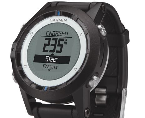
Holy Batman, the just-announced Garmin Quatix watch can connect wirelessly to a Garmin autopilot and not only show you what the AP is doing but let you steer the boat from your wrist. Plus if you fall overboard the lost wireless connection will set off an MOB alarm on a Garmin MFD and the AP will try to steer back to you. I hereby rescind my recent mumbling about Garmin's conservative approach to marine electronics!  And aside from all the connectivity -- the Quatix can apparently interface with Garmin PC, Mac, and iPad apps too -- it seems like a heck of a boating watch even if you aren't running other Garmin gear...

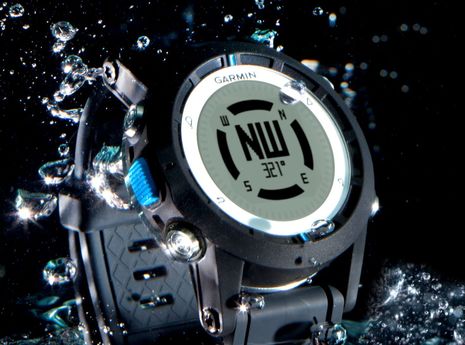
The Quatix -- I think it's pronounced like "aquatics" without the 'a' -- is purportedly lightweight, tough, and waterproof to 50 meters. It's equipped with "ABC sensors" -- altimeter, barometer and compass -- and in this case compass means a 3-axis electronic sensor that can will supposedly hold onto your wrist's heading no matter how you move it...
Garmin_Quatix_compass_screen.jpg

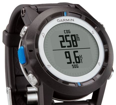
And of course a Garmin watch also includes a GPS, and probably a very good one, so it's possible to get your location, COG and SOG.  Note though that Quatix battery life goes from six weeks to 16 hours when you enable the GPS, and also that it's not clear yet how you charge the thing. Actually there are many unanswered Quatix questions in my mind. We're told, for instance, that it has has basic watch functions like "alarms, chimes, various vibration alerts, timer, stopwatch and a world clock with the ability to display several time zones" but can it also correct itself using GPS atomic clock time? I'll bet yes...
Garmin_Quatix_COG-SOG_screen.jpg

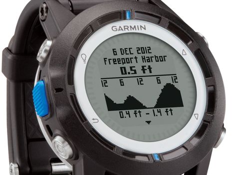
I'm also guessing that the neat tide level graphs seen below are built completely into the watch and don't need a connection to other Garmin equipment, and also that it will pull up the tide closest to your location, but I'm hoping for confirmation from Garmin. My biggest questions, though, involve the connectivity, which sounds amazing. I can picture, for instance, how just the Quatix can be used to set up a racing sailor's starting line and "calculate both distance to the line as well as desired speed and burn time available" but what's up with the "tack-assist" mode that indicates lifts and headers? Will you have to manually enter wind data or will the Quatix be able to get it from a Garmin system using its built-in ANT wireless technology (or will both be possible)?  Similarly, and of interest to all sorts of boaters, what are the details of "integration to both BlueChart Mobile {reviewed on Panbo} and HomePort {also reviewed} by allowing the user to transfer waypoints, routes and tracks via ANT"?...
Garmin_Quatix_tide_screen.jpg

Hopefully Garmin will start revealing more information about the Quatix soon, price included, and it will supposedly be available to try by April. I'm intrigued with all that it promises, but probably the biggest factor for its success will be ease of use. Almost ten years ago I tested a Suunto M9 "wrist-top computer" that was almost as ambitious but it was a bear to use and not very reliable either. It didn't catch on. However, today's GPS chips and other sensors are far better and Garmin is expert at making complexity in small devices usable. In fact, when I look at the watch-like gear the company has already developed for other sports -- like the Forerunner 910XT -- the Quatix almost seems obvious.
   In fact, I spent some time scouting around for other possible hints at future marine developments. While I guess the new BarkLimiter doesn't count, it does show how niche Garmin is willing to go (and there are some boats out there that could use some bark management ;-). But how about the K2 Infotainment Platform prototype that Garmin showed off at CES. In fact it shares a lot of a features like voice controls and deep smartphone integration that I've been experiencing recently with my Ford Touch and Sync My Ride systems, and I'm planning to write about those on Panbo because I can see ways they'll come to boating eventually. I was already looking forward to the a slew of new gear Garmin is promising at the upcoming Miami show. Do you agree that the Quatix suggests that we might see more innovation than expected, and the K2 suggests that it won't stop?

Garmin_K2_prototype_vehicle_infotainment_platform.jpg

PS: Garmin just put a special Qautix site and, even better, detailed shop pages. The Quatix will be $450 once FCC approved and, yes, it can receive NMEA 2000 wind, depth, and other data from your boat system using another new product called the Garmin GNT10 NMEA Transceiver. That may mean it can work with any N2K instrument system. Holy cow!

Comments

Yes, maybe I should have waited a while to write about this because it seems like the embargoed press release that Garmin sent out a while back was a bit vague ;-)

For instance, now it looks like the watch's MOB function is actually an active and automatic system something like Raymarine's LifeTag (which also uses ANT, I think): "Should a crewmember wearing a quatix fall overboard, quatix will automatically send an MOB alert to the chartplotter (requires GNT™ 10 NMEA Transceiver sold separately)."

The Qautix also includes a temperature sensor or may be able to talk with the wireless "tempe" sensor listed as an accessory, or maybe both!? Charging is by USB, which also handles the connection with HomePort planning software. Getting to an iPad running BlueChart Mobile probably requires an ANT dongle, but since Garmin is also out with the N2K ANT transciever, will it let BCM connect to that too?

There's a little more info on the GNT10 transciever up, like the $200 price: http://goo.gl/ZheUj

Finally, I notice a "map" command on one of the Quatix screens I hadn't seen before. A map in 70x70 pixels? Well, there's no illustration but maybe it's something like what Garmin is doing on the "fēnix" hiking watch, which actually looks quite similar to the "quatix": http://sites.garmin.com/fenix

Posted by: Ben E at January 17, 2013 10:19 AM | Reply

Ben, I want this. How cool. I would buy it today if I could. I suspect that this is a portent of new products very soon to come, and a lot of it.

Posted by: Bill Bishop at January 17, 2013 10:59 AM | Reply

This will be very attractive if I can get NMEA data out of the nav station and onto the wrist's of my rail meat.

P.S. Garmin, please introduce an updated MFD soon.

Posted by: Paul at January 17, 2013 12:27 PM | Reply

Hmm. Just as I prefer APs to steer to a course and not to a waypoint, which encourages a process of observation and corrections for set, drift and other variables, I'm not sure this is a great idea. I like the concept of some kind of COB integration with a watch: imagine the "traditional" lookout pointing at a COB who is periodically vanishing behind a swell. The lookout could point with some kind of verification of bearing based on some sort of Lifetag.

But AP through a wristtop thingie, plus GPS, plus baro, plus time? Too many eggs, not enough basket, I think.

I'm no Luddite: I have a venerable Suunto Vector that I consult regularly for its compass and particularly baro features, but its battery lasts 9-12 months, not days to mere hours. I also think it would be a special kind of connector to charge every day at sea and not turn into green slush.

I would, however, like to hear more when more is known.

Posted by: M. Dacey at January 17, 2013 12:56 PM | Reply

OK, now that I'm totally confused by the features of a watch that isn't available yet...Ben's take on an MOB beacon that tells the AP where to go to pick up the MOB is a brilliant idea, particularly for single handed sailors. The possibility of being run over by your own boat aside, I think you're onto something Ben, and it sounds quite doable, though not probably by a watch.

Posted by: Reed Erskine at January 17, 2013 2:34 PM | Reply

Sorry to be confusing, Reed! I just rewrote the opening paragraph to better reflect the information Garmin released today. Yes, apparently you can change autopilot heading with the watch. And, yes, if you fall overboard apparently the lost ANT connection will trigger an MOB alarm on a Garmin MFD and/or tell the AP to reverse direction. Obviously a lot of things would have to go right for a singlehander to get back aboard successfully, but then again it might a good start for a boat with two or more crew.

Since this is all being done via NMEA 2000 messages it will be interesting to see what works across brands. I'd guess that the MOB alarm is quite possible, but the AP control not so much.

Posted by: Ben E in reply to Reed Erskine at January 17, 2013 2:54 PM | Reply

Garmin Fenix watch also have (undocumented, but working) map display feature. Some people managed to put there simple trail maps and that's good to have it for emergency, like a spare gun.

Posted by: Bushman at January 17, 2013 2:59 PM | Reply

GPSTrackLog has a thorough review of the Garmin Fenix:

http://gpstracklog.com/2012/10/garmin-fenix-review.html

Aside from different boating and hiking oriented software features, it seems very similar to the Quatix with two interesting exceptions. It claims 50 hours of battery life with GPS on (though maybe sleeping intermittently) and it also has Bluetooth for direct connection to mobile devices.

I think it's possible that the Quatix also has Bluetooth. Garmin is a little sneaky about such stuff. For instance, the Quatix "Specs" don't list any kind of wireless. And when the GPSMap 741 Series was announced in November, at first they just said 'full wireless capability' but later told me that it had "WiFi, Bluetooth, and ANT". Ant is still not listed in the specs and may have been a mistake.

At any rate, I think Bill's right about lots of things to come, with lots of wireless options.

Posted by: Ben E at January 17, 2013 3:23 PM | Reply

Harrumph! Perhaps an underlying theme to this entry is that Garmin is a huge powerhouse of innovation but also so big that few people know, or dare say, what's actually going on.

At any rate, now it turns out that while the Quatix does provide automatic MOB (or COB) alarms and a Garmin AP can reverse course for it, there is a human command needed in between. Probably a good idea when I think about it, but sorry singlehanders.

On the other hand, I'm feeling a bit like a good detective because now I'm hearing that the Quatix does indeed have Bluetooth Low Energy (BLE) -- though mentioned nowhere -- and thus can connect directly to several recent iPad and iPhone models. Holy Batman!

Posted by: Ben E at January 17, 2013 6:44 PM | Reply

You gotta love the Quatix website, which includes a "gallery."

The second picture shows a boat full of B&G displays (at least 4 in the picture).

{Please don't write; we now know that they are actually Nexus displays, and Xavier is embarrassed. Read on. -- editor}

That's what happens when brands outsource website creation/management to advertising agencies... the ad agency drones typically have no concept of the product they are being paid to peddle.

By the way, I will be getting the Quatix.

Posted by: Xavier Itzmann at January 17, 2013 10:22 PM | Reply

I would bet that this is based on TI's Chronos watch wireless development kit.

When that came out 2 years ago I had the same idea to build an AP remote control. I even bought two of the kits. It never happened of course -- so many ideas, so little time!

The TI RF SoC is a single chip that contain both the microprocessor (and memory etc) as well as the radio. The radio can be provided in three frequencies, but Garmin probably uses the one that can be used globally which is 433 MHz.

See http://processors.wiki.ti.com/index.php/EZ430-Chronos?DCMP=Chronos&HQS=Other+OT+chronoswiki

Posted by: Kees at January 18, 2013 6:07 AM | Reply

Kees, doesn't ANT wireless -- which Garmin says it's using -- operate in the 2.4 GHz range? I see that TI makes a chip with both ANT and BLE which sounds more like this watch.

Posted by: Ben E in reply to Kees at January 18, 2013 7:10 AM | Reply

Ben, you're right. I hadn't realized that in capitals ANT is a full RF network spec.
What's more, Wikipedia says:

The ANT protocol is designed and marketed by Dynastream Innovations Inc., a Cochrane, Canada based company, which in turn is a wholly owned subsidiary of GPS equipment manufacturer Garmin.

http://en.wikipedia.org/wiki/ANT_(network)

Send me a hat and I'll try eating it...

Posted by: Kees at January 18, 2013 8:55 AM | Reply

I do want to send you a Panbo hat, but only if you wear it! Interesting that Garmin owns ANT. I've used it excercising with a Garmin heart monitor and a DigiFit dongle that fits in my iPod Touch. No issues and I've yet to change the battery in the monitor...but then again I don't get to the gym that much.

Posted by: Ben E in reply to Kees at January 18, 2013 9:30 AM | Reply

It would be great if the watch could also be my anchor alarm. I would love to be sleeping down below and have the watch beep as my anchor alarm.

In addition I noticed that there is an ANT adapter for the iPhone. http://www.thisisant.com/directory/garmin-ant-adapter-for-iphone/ Perhaps I don't need to use WiFi to have data from my chart plotter on my iPad and iPhone.

Garmin seems ready to announce a bigger strategy. I wonder if we are just going to see products - Or a bigger strategy.

Posted by: Pat McQueen at January 18, 2013 10:00 AM | Reply

Pat, there is a mention anchor drag alarm on Garmin's blog: http://tinyurl.com/garmin-blog-quatix

"As an ABC watch (altimeter, barometer and 3-axis compass), quatix also provides pivotal marine datum such as COG (course over ground), SOG (speed over ground), and VMG (velocity made good), along with alerts for speed and anchor drag."

Aside: Why has it become popular to not capitalize the name of a product? Why "quatix" instead of "Quatix"?

Posted by: Ben E in reply to Pat McQueen at January 18, 2013 10:10 AM | Reply

Ben,

I think the social media generations are trying to do without any capitalization at all. Maybe it's the my-phone-is-supposed-to-do-that-for-me attitude?

Posted by: Kees at January 18, 2013 10:29 AM | Reply

Xavier - the graphics in the gallery are showing Nexus products. Garmin recently acquired Nexus, so those are technically Garmin owned products.

Posted by: Julie in reply to Xavier Itzmann at January 18, 2013 10:31 AM | Reply

Thanks, Julie. I asked Garmin about Nexus at the Fort Lauderdale show. As always, they were quite cautious about discussing future products but they did did seem interested in serving both cruising and racing sailors.

Posted by: Ben E in reply to Julie at January 18, 2013 10:36 AM | Reply

Julie,

Ouch! You are absolutely correct, of course. The instruments on the Quatix photo gallery are Nexus, a Garmin subsidiary.

My mistake, and quite embarrassing too! My apologies to the marketing team and I should be more careful next time with my comments.

Quite frankly, if Ben could make an exception and delete my quite inconsiderate original posting, it would be appreciated.

Best,

Posted by: Xavier Itzmann in reply to Julie at January 18, 2013 11:15 AM | Reply

Sorry, Xavier, but that gets too complicated. Besides it good sometimes to serve as an example to others, and most of us get our turn ;-)

I got confirmation from Garmin that the Quatix can connect via Bluetooth LE to an iPad running BlueChart Mobile, no ANT dongle needed.

Posted by: Ben E in reply to Xavier Itzmann at January 18, 2013 11:34 AM | Reply

I WANT!!!

Two questions:
1) if the boat is wired with a Garmin transceiver, can it use GPS coordinates from that for location and allow you to turn off the GPS receiver in the watch (saving battery)?

And would it work with other autopilots or Garmin only?

Posted by: Graham at January 18, 2013 11:55 AM | Reply

Good question Graham. In addition I wonder if data from the watch will upload to the Garmin MFD's, and then how would you select the data sources to stop any conflicts, ie an additional GPS, or a second barometric pressure data source.

I don't think The Garmin watch would talk to any other AP's. That's a pretty specific function and differs with each MFG.

Posted by: Bill Bishop at January 18, 2013 12:35 PM | Reply

How about an N2K chain counter that reads on the watch, and chain up/down buttons on the phone? How cool would that be!?

Posted by: svHaven at January 18, 2013 3:36 PM | Reply

Hi Ben,

I wonder if it would work with the Garmin Gladiator TR1 which was there first autopilot that I had installed in 2008.

thanks,

Posted by: Ray at January 19, 2013 2:56 PM | Reply

I'm exhibiting the dog's side of Pavlov's experiments.

In time past, only the bacon thing worked on me. Thanks Garmin; I'm evolving!

Posted by: Sandy Daugherty at January 21, 2013 9:20 AM | Reply

While it's aimed mainly at sailors, the YouTube video Garmin UK just put up seems like the best summary of Quatix features yet:

http://www.youtube.com/watch?feature=player_embedded&v=iMYy1yWnwPw

Posted by: Ben E at January 21, 2013 6:59 PM | Reply

Interesting that there is a few "smartwatches" coming out including an open source one - Metawatch, DiYers could knock up a similar version to quatix!!

Dave

Posted by: Dave at February 8, 2013 9:34 AM | Reply

Dave,

I had the same idea 2 years ago when this came out: https://www.sparkfun.com/products/10019

but I never got round to it. DevKit is still lying 'round here gathering dust!

So many gizmos, so little time!

Posted by: Kees at February 8, 2013 9:43 AM | Reply

I was one of the 85,000 Kickstart "investors" in the Pebble watch, so I should finally get one any day now. SDKs for Android and iOS are available. Offhand, I can't think of any boat apps for it, but I'm excited about seeing who's calling or texting without having to take my phone out, and I think I'll have very accurate time on my wrist...

http://getpebble.com/

Reminds that one possible meaning of "Panbo" is Personal Area Network Boat. Really!

Posted by: Ben E at February 8, 2013 10:57 AM | Reply

We saw the Quatix yesterday at the Miami show. It is a handsome piece. The bracelets come in black and gray.

Now, carefully reviewing the documentation, it seems that the MOB functionality works only with Garmin chart plotters?

So, MOB waypoints are not part of the N2K standard? At the end of the day, an MOB waypoint is just like any other waypoint, except it has a different data flag and therefore a different icon, correct?

I think having the 1st mate and I wear these watches is a more natural alternative to wearing, say, the Ray LifeTag, and a nice backup to the real MOB systems (McMurdo S20/Safelink R10, OrcaDSC, etc)

Curious in Miami.

Posted by: Xavier Itzmann at February 17, 2013 3:24 PM | Reply

I was thinking if Garmin will release a Wireless, Solar-powered, Wind station like Raymarine Tacktick (former Suunto) that will support ANT+ to work with this watch...

Best
Walter

Posted by: Walter Silva at March 26, 2013 9:46 PM | Reply

I got my watch yesterday. I downloaded the Garmin Bluechart software for my iPad as directed on the Garmin site. What did I find? It never worked.

I contacted Garmin support to find that this does not work and may! be in a future release of Bluechart.

In addition to this the temperature was reading 5 deg high.

Here is the advice from Garmin "You need to buy a chart plotter and an external temp sensor". After all its a watch.

Can't wait to test it on the water!

Posted by: Nuck in reply to Walter Silva at April 30, 2013 5:24 PM | Reply

Nuck, I have a question in to Garmin about what is supposed to happen between the Quatix and BlueChart Mobile, but it's obviously not working yet. However, the Quatix and HomePort pc software work beautifully together. HomePort automatically downloads any tracks and waypoints you've created on the watch and you can drag any other routes, waypoints, etc. you have in HomePort to the watch. It also handles Quatix software updates.

I didn't have high expectations of accurate air temp on my wrist but I think you'll be amazed at how good the Quatix GPS, compass, and barometer are.

But note that at least my Quatix sample is not streaming NMEA 2000 well. It does it, and it doesn't matter the source on the boat, but many of the values are not the same as what you see on the boat. I'm sure Garmin will get it straightened out, or maybe either my sample watch or GNT 10 is somehow messed up.

Posted by: Ben E in reply to Nuck at April 30, 2013 8:39 PM | Reply

Check out the Leikr watch. It has ANT+, Bluetooth 4.0, WiFi, colour screen, GPS built in, and can use maps.

http://www.dcrainmaker.com/2013/01/hands-on-with-the-new-leikr-gps-sports-watch.html

Now if THEY made a nice sailing interface - that would be a cool solution. Maybe Navico should consider buying them - being a Scandinavian company :)

Posted by: Kasper Larsen at May 1, 2013 2:09 AM | Reply

Does anyone know yet for sure, that if you have a Garmin Autopilot (GHP 10 for example), which has an ANT antenna already built in for remote autopilot interface...will it also stream the N2K data? Or do you also have to add the GNT-10 Antenna to get the streaming N2K data? Maybe the GHP-10 ANT system only supports the watch to autopilot connectivity? Thanks.

Posted by: SaltyG at May 1, 2013 3:52 PM | Reply

I've had a Quatrix on my wrist for a month, and I'm overall very impressed with it. As Ben said, it plays well with Home Port. I used it in a regatta last week and programmed the race course into it. It worked a treat. At every turn it produced the bearing to next, and gave us the XTE, and bearing. I have also driven a boat with a Garmin HP10 pilot with it and it worked great there. The Quatrix is influenced by your body temp.I know that maps and charts can apparently be downloaded to the watch, but I haven't gotten that far, and the ANT doesn't stream data back from the pilot. Current software is 2.20 as of April 12. I think there is much more to come.

Posted by: Bill Bishop at May 1, 2013 4:02 PM | Reply

The watch is now available and I'm drooling for one. Garmin sales team seems horribly uneducated. I'm waiting for a review on this site before I buy.

Posted by: TonS at May 24, 2013 10:33 AM | Reply

Now that the original quatix and GNT 10 can be had for less than $300, I got a set and have been using it for three weeks. It delivers on what I wanted it for.

My use case is simple: we live on our boat, anchor out most of the time, and I rejected years ago the idea of installing an MFD or instrument repeater in our sleeping cabin, just out of aesthetics. But when the wind picks up at 2 AM, it is nice to not have to go to the nav table to see what's going on. Yes, we have GoFree on the iPads, and on very rare occasions we've kept an eye on radar by the bedside via iPad, but it is not a "lightweight" solution for just knowing how much wind is there, for example.

It took 1 minute to install the GNT 10, as my N2K net already had an open T-connector. The quatix, on the other hand, I played with for many hours because of its wealth of settings. I sent waypoints from the iPad via Garmin Bluechart app, for example. Most of these functions I will never use. I guess in a true emergency in the middle of the ocean, the watch's world map and compass could be handy!

In the end, I configured a couple of N2K screens: one I use at anchor, and one I use when sailing. If I know there will be some wind at night, I turn on only the boat's N2K net, do 3 key-presses on the phone, and I have the info I need on my wrist with ease and very low power consumption.

Four nitpicks: 1. N2K depth on the watch fails as soon as I turn on the boat's chart plotters (!)(?) All other N2K carry on being presented on the watch. 2. N2K depth on the watch does not have the sounder offset. 3. I couldn't get the "Anchor Drag" function to work at all, and not even with internal GPS nor with N2K. I have other resources for anchor watch, no problem. 4. The GPS antenna is so incredibly weak, that out of 10 battery-powered devices with GPS on board, this is the _only_one_ that does not work below decks.

Notes: there is no other Garmin hardware installed (B&G boat). The quatix Garmin full manual .pdf download is a bit perfunctory.

Posted by: Xavier Itzmann at September 17, 2016 4:55 PM | Reply

Thanks, Xavier. It sounds like the Quatix and GNT 10 are working well for you and I notice in the GNT 10 install PDF a fairly long list of N2K data PGNs that should show on the watch:

https://buy.garmin.com/en-US/digital/shop-by-accessories/nmea-2000/gnt-10-nmea-2000-transceiver/prod124640.html

But I also noticed that on Amazon the GNT 10 is listed as frequently bought with the Quatix 3 as well as the original Quatix and that's troubling! Garmin seems to have changed the way they do ANT and it may be causing confusion. Readers should understand they can not do what you did and then later move up to the Q3. It doesn't work with the GNT 10, only with Garmin's latest MFDs. It also doesn't have autopilot control or an MOB function, though the Q3 is an excellent smart/fitness/boating watch.

Posted by: Ben E in reply to Xavier Itzmann at September 18, 2016 10:02 AM | Reply

Ben, yes, thanks, I had looked at the GNT 10 manual before, but now that you pointed it out again, I see the following.

The manual includes "NMEA 2000 PGN Information", and it reads:

* Transmit and Receive: 3 items
* Transmit: 2 items
* Receive: 18 items

Well, the way I interpret it, the GNT 10 is not a gateway N2K > ANT, but instead, it is mostly a sender N2K to ANT. It _receives_ from N2K a lot of PGNs, but it only sends to N2K a handful of things. I.e., it can only send _to_ N2K info about itself (to correctly show on a "network device list" as it does on my B&G) and a limited number of _commands_, presumably the MOB and autopilot commands that only Garmin hardware can decode.

If this interpretation is correct, this would explain why GNT 10 is not at all compatible with Garmin gWind Wireless 2: it cannot receive wind data from ANT.

Less clear is why quatix 3 is incompatible with GNT 10, but I have a hypothesis: quatix 1's flaw of not having sensor offsets nor instrument damping is probably addressed by quatix 3 getting this data already massaged/managed by a proper chart plotter/MFD.

Posted by: xavier Itzmann at September 18, 2016 10:53 AM | Reply

I don't know either, but caution people to be very careful about Garmin marine compatibility these days. They're doing some great new things in my opinion, but lots of backward compatibility has been lost while they change underlying software and communications like ANT. (The phenomenal VIRB camera WiFi integration is a good example, because it doesn't work with older Garmin WiFi MFDs or older WiFi Virbs.)

Incidentally, while the GNT 10 will not communicate with the gWind Wireless 2, the displays that do work with the gWind 2 do bridge the wind data to NMEA 2000, so it will be available to the GNT 10 that way.

Posted by: Ben E at September 18, 2016 11:17 AM | Reply

Leave a comment