Hurricane Irene, the long anchor watch #1
... written for Panbo by Ben Ellison and posted on Aug 28, 2011
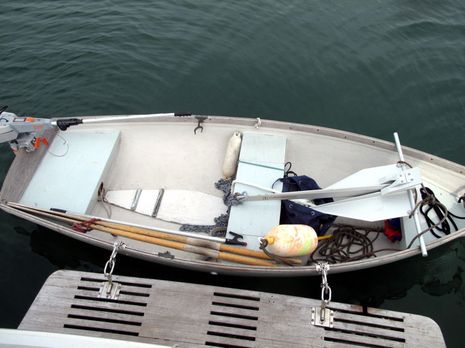
Gizmo_anchor_kedge_setup.jpg

So it's Sunday morning and the early signs of Irene are here in the form of 100% humidity and easterlies in the high teens. That wonderfully large Fortress 55 anchor, seen above in my tender yesterday afternoon, is now set about 150 feet to weather in 20-30 feet of water and Gizmo's regular hook, a Kingston K-45, is about the same distance to the southwest. The best part, though, is that I'm snugged into Pulpit Harbor where it's quite unlikely that I'll experience any significant wave action. In my experience it's that action and the resulting line chafe that usually causes boats to go ashore in conditions like we're expecting. You can see Gizmo's position on this Spot share map, and I'm also using this situation to try out a number of other electronics...

For instance, I'm using the anchor watch feature on the Vesper WatchMate 850 AIS; it would be better if I'd gone to the trouble of wiring in NMEA 0183 heading info, but I think it's still my most accurate monitor and it will alarm if Gizmo makes a serious move. I've also been experimenting with a Garmin GTU 10 GPS locator as an anchor watch this summer. It's real value is for when you're off the boat, like the Boat Monitor app, but both the AT&T and Verizon coverage right here is just dicey enough to give both a good work out.
   Fortunately though, a friendly nearby household is serving WiFi Internet to Gizmo's Rogue Wave, and so I'm able to see what's happening with Irene south of here. I've been watching the NHC's predictions and discussions for days now, and have become another fan of Dr. Jeff Master's blog, but what I like to do at this point is to mind the weather bouys (I do have a third anchor ready). I like the GoMOOS site for New England, but I also went right to the NBDC for some recent Irene history. I'd say that this storm is relatively mild in terms of wind -- knock on wood -- but it's hard to diagram the effects of an intense low better than this data screen from the Cape Lookout, NC, station, though it leaves out the radical east to west wind shifts. (That station, incidentally, is actually on the beach, and years ago my shipmates and I -- looking at all the wreck symbols on a wet chart in a stressed boat -- concluded that the proper pronunciation for that spot is "Cape Look Out!")
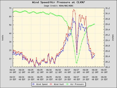
Irene_seen_on_Harkers_Island_weather_bouy.jpg

I'll write more about using electronics during tropical storm Irene eventually, but I'll close now with something lighter. Coming to Pulpit gave me an opportunity to visit the Maine Cat P47 Cacique, seen nicely in this Billy Black YouTube video.  It was neat to experience the very comfortable semi-custom interior that was envisioned by long time cruisers Pam and Glen when I first met them a few years ago -- no lower helm in favor of serious recliners, and a raised foward sole for excellent all around sight lines. I was also pleased to learn about boat-friendly Bota Box wine, posed below with boat cat Rocky (and sibling Tigger on the foredeck).  The concept is simple, a 3 liter box/bag made of 100% recycled materials that's easy to stow and leaves little to get rid of. It's also inexpensive, and I agree with this reviewer that the Malbec is pretty good.
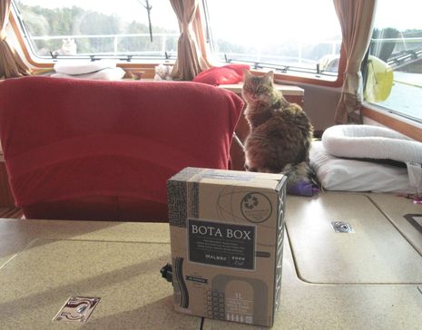
Bota Box wine n cats onboard cPanob.jpg

Comments

Ben, a suggestion for box wine. We leave the boxes on the dock. We store the bags in plastic bins and have plastic grain storage pantry bin we have modified to hold the wine bag in use (deep open slot for the valve assembly).

Liquor stores don't necessarily have to have the same pest control as grocery stores/warehouses (where we are). We have found roach and silverfish eggs in pretty fresh boxes.

Posted by: Christopher at August 28, 2011 12:31 PM | Reply

All fine here. Looking at the Penobscot Bay buoy GoMOOS F01 ten minute history, sustained winds only broke 30 knots once. The odd thing is that the actual wind speed and direction closely tracked the GFS model predictions that NOAA was generating late last week and throughout the weekend (and other models viewed with the WeatherTrack app). But the NOAA audio and text forecasts were for significantly higher wind speeds. What's up with that?

Nonetheless I was glad to be in a very protected spot on two well set anchors, and it was good practice at handling the ground tackle solo. The Torqueedo-powered ( http://goo.gl/MVd8J ) tender turns out to be excellent for kedging that big Fortress and chain. It hadn't occurred to me that the torque and precise forward/reverse control would be useful for this.

Posted by: Ben E at August 29, 2011 8:47 AM | Reply

Chicken Little got a gummint job. With NOAA.
The tragic downside is that the General Public now discounts Weather Warnings no matter how well supported by hard science they have become. For the absolute majority of listeners, all those warnings never came true. Ergo, Chicken Little (after consulting with his Personal Liability Attorney) must make even more dire warnings to get people to take all the proper precautions. Pretty soon, "GET OUT NOW or DIE" will elicit no more than a get-out-now party on the balcony.

Posted by: Sandy Daugherty at August 29, 2011 12:47 PM | Reply

The forecasts didn't look too bad, but my mooring hasn't been checked in a couple years, so I took "Barbara" around to the other side of the island. the glass got down to about 29" but we only saw winds in the 30s (ini the lee, of course). Worst part was power went off on Chebeague so naturally the wi-fi hotspot I was stealing from went down. We jogged back home at about first light after the wind went to the westward.

We usually take several cases of Bota boxes with us when we go south each year. Wine tends to be expensive in the Caribbean (rum is cheaper, but we prefer wine with meals).

Posted by: Michael at August 29, 2011 1:09 PM | Reply

I spent the storm on land, but still found the noaa site very useful.

http://www.nhc.noaa.gov/graphics_at4.shtml?5day?large#contents

I especially found the wind speed probabilities useful for deciding just how far I should go in disassembling above deck components of my sailboat.

Posted by: Dan Corcoran (b393capt) at August 29, 2011 1:20 PM | Reply

Good article! I often wish folks would take more time to understand proper mooring techniques for wind storms - It's a subject that is often ignored even with threatening storms. Most boats that suffer losses are due to schaffed ropes and from other boats that slam into them.


I often forward an article (many years old) to friends... that clearly outlines Ben's strategy of the two large anchors.

Good work!

William from windy South Florida.

Posted by: William P. at August 29, 2011 10:09 PM | Reply

I'm pleased that many people took the warnings seriously and took steps to secure their vessel and keep it safe. I'm also a little puzzled by comments that imply the warnings were over-egged. Given the difficulties in accurately predicting the behavior of what is after all, a chaotic system, it seems to me that it was only ever a slightly better chance than evens for the storm to loose much of it's power by the time it reached Long Island. It could have re-energized. Still, I'm commenting from far away so those of you on the ground may know better.
What I'm certain of is that even with a 5% chance the storm would hit my area, I'd want to take the sort of precautions Ben and others ensured they did. I'd not want the warnings to be played down
In my mind, I can hear the sort of recriminations that would happen if national and local leaders failed to take all the steps they could to impress on people the possibility of serious damage and harm to the person.

Fishwife in the sunny Med.

Posted by: Fishwife at August 30, 2011 6:05 AM | Reply

But will people keep taking precautions if it seems like hurricane warnings are exaggerated? Here's a weather guy who writes "there is really no reliable evidence of hurricane-force winds at any time the storm was approaching North Carolina or moving up the East Coast": http://goo.gl/Mw9nV

I think he's not only got a good point but also that the weather models barely predicted hurricane force winds to reach Hatteras, let alone north of there. I have tremendous respect for the National Hurricane Center (which I got to tour once), and I know that part of their methodology is to back check their predictions against what actually happens. I wonder what they will conclude about Irene.

Posted by: Ben E at August 30, 2011 9:56 AM | Reply

NOAA was spot on re: Nantucket Sound / Irene forecast.

Steady 50, gusts to 65+ Sunday PM.

Pretty much what happened.

Posted by: Paul at August 30, 2011 1:38 PM | Reply

I'm guessing you mean miles per hour, Paul? Here's the weather buoy history for Nantucket Sound, which shows sustained 40 knots for just one half hour period, and gusts slightly over 50 knots in three periods: http://goo.gl/5O82r

Our marine forecast 175 miles north of you was for more wind than that.

Posted by: Ben E in reply to Paul at August 30, 2011 2:41 PM | Reply

MPH ... as recorded in HarwichPort.

Posted by: Paul at August 30, 2011 5:37 PM | Reply

Leave a comment