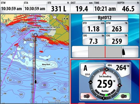
A couple of weeks ago I replaced Gizmo's older Simrad autopilot with the latest generation, which turned out to be easy even though I've never installed an AP before. It helped that there was no drive involved, just wire swapping, as the AC12 processor simply controls a solenoid plumbed into the boat's engine-driven hydraulic steering system. Plus the existing Simrad rudder sensor wired to the AC12 without trouble, and I already had a SimNet backbone in place. So I replaced the old AP11 control head at the lower helm just by plugging an AP28 head into SimNet, and did nothing on the flying bridge (except replace the existing AP11 with an extra instrument display) because I no longer need a control head up there. That's because I'm using the new NSE autopilot mode that was announced in Miami as part of its 2.0 software update. I like it a lot...
Oops: "Between July 27 and August 19, 2010, while conducting development testing of its Nationwide Automatic Identification System (NAIS), the Coast Guard inadvertently tele-commanded most AIS users transiting the Eastern United States between lower Connecticut and North Carolina to switch to AIS frequencies other than the AIS default frequencies (161.975 MHz - Channel 87B - 2087 and 162.025 MHz - Channel 88B - 2088)..."
At the risk of sounding mean, what excites me most about Furuno's new GP-33 GPS sensor and display is what it means regarding the coming RD-33 data display we discussed a while back. That 4.3-inch 480x272 pixel LED-backlit screen -- seen above in bright sunlight on Gizmo's flying bridge -- is pleasingly crisp and bright. And note how legible and even handsome the screen designs are, and how Furuno has dropped some of the numerical over-precision that has drawn criticism from users of NavNet 3D MFDs and FI50 instruments. You get all that screen goodness -- 50% more area than a Garmin GMI 10, Furuno claims -- for a maximum of 7 LENS (350 milliamps) of 12v power off a NMEA 2000 backbone...
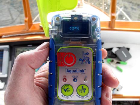
The first time was the best. I was tootling down the Bay in May when I tested the ACR AquaLink View PLB. I'd already appreciated its high build quality, and how neatly instructions about how to activate its two self test modes and primary distress function are explained right on the casing. Then when I pressed the GPS Test button for five seconds, it was very nice to have the small LCD screen show the procedure step-by-step and advise me to give the antennas a good sky view. And it was impressive that the GPS -- perhaps never used before, or at most tested in Florida -- got (and displayed) a position in well less than a minute. (In fact, the whole test procedure is so quick that I've had a hard getting a good photo with the scrolling screen in action.) But the kicker was how my cell phone buzzed a moment later with a text message confirmation that the beacon's test signal had made it through the COSPAS-SARSAT satellite system, along with a link to its accurately mapped position...
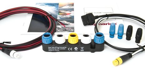
What's yellow, white, and blue, and will help a lot of boats integrate older Raymarine SeaTalk1 instruments and sensors into SeaTalkNG/NMEA 2000 networks? Well, check out the new SeaTalk-STng converter above, which retails for $95 and is also putting the Plus in Ray's new Raystar 125 Plus GPS. The manual PDF can be downloaded here, and I think it will please a lot of people who've messed with this stuff. Those yellow connectors above let you not only adapt a mini network of up to five SeaTalk devices -- like ST40 and ST60+ displays and their transducers, and/or a LifeTag wireless MOB system -- to a SeaTalkNG backbone, but also power them...
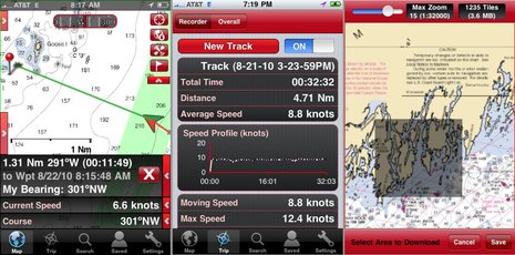
Not one but two iPhone NOAA raster charting apps debuted last week, and I had had a little Beta time with each. EarthNC for iPhone costs $25 and incorporates some fresh thinking and a lot of the resources EarthNC has long been developing for its Google Map & Earth overlay products, like EarthNC Online. They've turned all NOAA RNCs into tiles that download automatically to your phone as you pan and zoom, or you can batch download an area as illustrated in the screen at upper right. The left screen is busy looking, I know, but note how you can disappear each of those data and icon strips with the little red arrow. Note too how EarthNC is doing waypoint navigation and tracking, fairly elaborate tracking as shown on the middle screen. But that's not all...
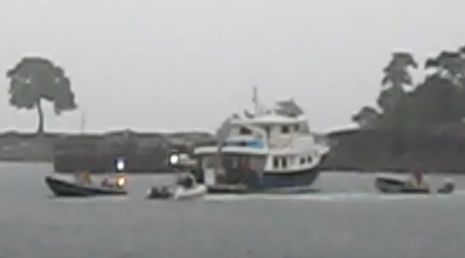
I'm generally quite reluctant to fault fellow boaters when things go wrong, because I've made about every mistake possible myself at some point, and probably will again. But what I hear about this scene, captured in part on YouTube, is a bit disturbing. That big beautiful trawler didn't actually drag onto the rocks around Northeast Point, but that's probably only because crews from from Wayfarer Marine, Yachting Solutions, and the Harbor Master's office worked hard to hold her off, in pouring rain and lots of wind. A local hero even managed to squeeze his way through a pilothouse window, figure out the complex starting procedure, hoist the anchor, and put the boat safely on a dock. But the owner, who showed up after the storm had passed, was apparently somewhat casual about what happened, though most boaters would know that a salvage claim was a possible road not taken by the rescuers, and...
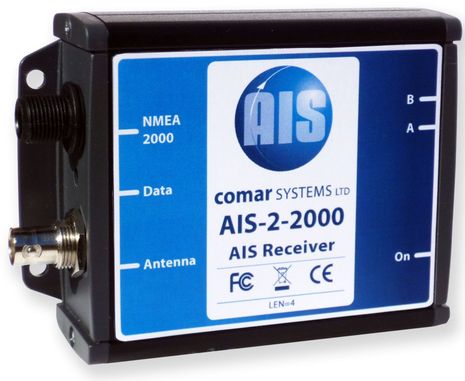
Sweet. Comar's new little dual band AIS receiver not only outputs NMEA 2000 but is powered off it. Could there be a simpler install? In fact, the AIS-2-2000 doesn't even have NMEA 0183 plotter or PC ports. But the way things are going, especially given all the charting programs slated to support the Actisense gateway, who needs no stink'n' 0183? Actually a lot of boats do, which is why the Digital Yacht AIS200N2K is a nice product to have in the pipeline. And actually you may recall that NMEA was none too quick about writing N2K PGNS to match all the 0183 AIS messages, but the Comar unit is designed to deal with that tardiness...
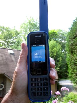
Maybe I'm missing something, but the Isatphone Pro seems every bit like the game changer Inmarsat claimed it would be. I've made calls from the boat and backyard, sent myself text messages and emails, and replied to them, but have yet to detect a performance issue. Plus I find the handset easy to use. And, mind you, this is a sat phone that's only been shipping for a month or two, and it's using an Inmarsat I-4 geosynchronous satellite orbiting about 22,000 miles over the equator at 98° West. As the phone is telling me in the photo above, it does like to have its antenna aimed vaguely at the bird, and I'd guess that would be even truer if I moved further north and/or east, thus putting more atmosphere between the phone and I-4 Americas. But consider that I'm at about 45°N and 68°W with a lot of trees around me, even to the southwest in the background (and that DirectTV couldn't get a decent signal here, even on a roof higher than the one you see)...and here's how I sound:
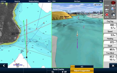
If I can miss major ways that MFDs display currents and tides, lord only knows how much I might mess up a comparison of 3D charting. There are so many aspects to 3D presentation, and virtually no bench mark as to what is right. In fact, I'm running the Raymarine E140 Wide screen shot first because it illustrates one of the few things that's clearly wrong, I think, which is to put the vessel on center, so that you get the most detail of the waters you've already passed through. But Raymarine has long offered good Look Ahead features in its 2D chart presentation (as seen in the left window, set at 2/3rds ahead), and I know that 3D Look Ahead is high on its list of planned software updates...