AIS users CT to NC, head's up!

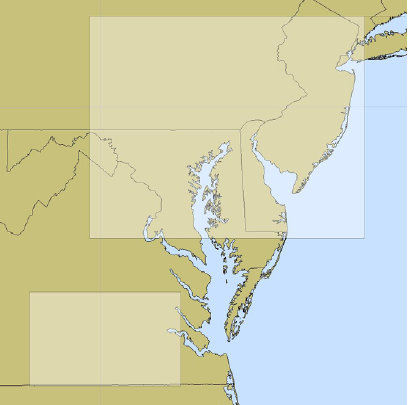
Oops: "Between July 27 and August 19, 2010, while conducting development testing of its Nationwide Automatic Identification System (NAIS), the Coast Guard inadvertently tele-commanded most AIS users transiting the Eastern United States between lower Connecticut and North Carolina to switch to AIS frequencies other than the AIS default frequencies (161.975 MHz - Channel 87B - 2087 and 162.025 MHz - Channel 88B - 2088)..."
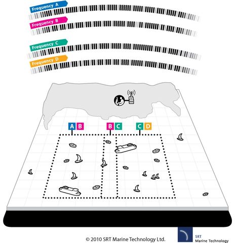
"As a result, those users within uniquely defined channel management regions (as shown in the picture) will neither see nor be seen by vessels operating on the default AIS channels when within these regions. Similarly, vessels operating on default frequencies will not see or be seen by those vessels that were inadvertently switched to other frequencies." You can download the USCG Alert 0710.pdf here. PS 10/1: SRT sent along a diagram illustrating how channel management can be used by the "competent authority" ashore to handle a situation where many transponders in a small area cause the standard AIS slots to fill up. The vessels in the right hand area have been switched to channels C and D, and can see each other fine but not the vessels using channels A and B. There is always a transition border around a changed channel area where vessels use one channel from inside and one from outside. For simplicity, the diagram only shows the transition zone along one border but, in fact, it would go all away around the C/D channel area. When done purposely, such channel management should be virtually invisible to transponder users (though AIS receivers would not see the vessels using channels C/D).

 Share
Share
Even if your AIS transponder didn't get messed up by this mistake, the pdf may be worth reading so you better understand a little used feature of the System.