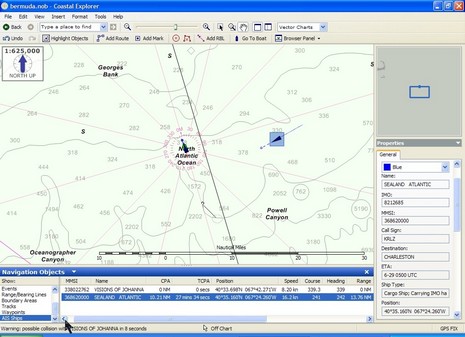
Check out the full size version of this Coastal Explorer (aka Maptech Chart Navigator Pro) screen. It shows how useful the Nauticast B AIS transponder was during the Bermuda-to-Maine passage, and suggests how it might have played a critical role. You can see that we’re just coming onto the continental shelf. It was no surprise that we drove right into a classic Georges Bank blanket of fog, but reassuring that the Nauticast B’s dual receivers picked up the Sealand Atlantic at about 25 miles, more so knowing that we were going to pass ahead of it with a wide CPA. Visions of Johanna’s 4kw open array Furuno NavNet radar didn’t pick up the ship (bow on) until about when this screen was made, and it wasn’t even a large target when broadside 10 miles astern. Had we been 10 miles further back on our track, and without AIS, the crossing might have been nerve wracking.
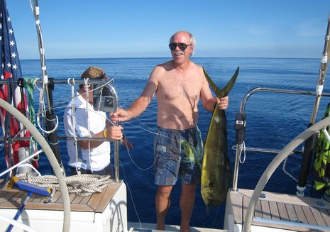
6/28 I’m now ashore and able to upload this shot of Malcom Willard showing off a three-meal dolphin on a lake-like Atlantic ocean. It was taken on Tuesday, a few hundred miles south of the Gulf Stream. I didn’t manage to get the text below online until Wed. afternoon. Note that no electronics played a part in the fish’s demise:
Note to self: If I ever get to try this again---posting a Panbo entry from offshore with a sat phone---
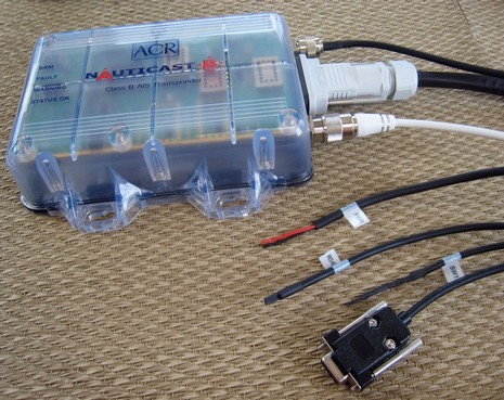
As hoped for, waiting in Bermuda was an ACR Nauticast B Class B AIS and, happy day, I got it installed and working without a problem. In fact, I’m really impressed with the detailing—packaging, cabling, instructions, etc.—and also the variety of ways you can set it up. I’ll discuss all, not to mention how it works underway, when I have more time. Right now, I’m just going to use my last high speed connection for a while to put up some pictures. The hardware one above is bigger here
, and the software that comes with, below, is bigger here. I do have the Iridium/Xgate email working (nice!) but xWeb still eludes me, and so may not post again until we reach Rockland.
Actually I may be in Bermuda, and able to get online, for a few days. On the other hand, I might have some difficulties getting the gizmology through security! Then again, maybe I can figure out how to post via Iridium. Let’s just say…sporadic until about July 1.
6/22: I made it! But, damn, WiFi is tight in Bermuda. $5/hr, $50/day, or $150/wk at the Dinghy Club here in Hamilton, and most everyone has their home and business AP's locked up solid. I know because I've been wandering the streets with that Nokia N800 in the picture. Finally found a good and open connection in a little mall. Am typing this using a ThinkOutside Bluetooth keyboard. Feeling pretty geek except I just tried going native with a marsala omlett with chili peppers in it. May have been a bad decision.
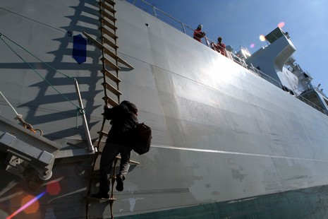
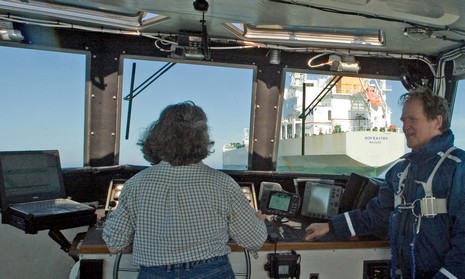
That’s Skip Strong making his way down Nor’easter’s twisty pilot ladder, as seen from the bow of the Penobscot Pilot. Man, that move must get the adrenaline pumping, say, on a dark night with a big sea running. (Capt. Ryan told me that they can manage a ladder like this in up to about eight footers, sometimes getting the ship to turn toward the ladder and using the flatter turbulence created inside the turn). At any rate, Strong, who is a bit of a geek (and I mean that in a good way) has quite the electronics in that bag he’s toting.
I’m way behind on work, not to mention the gizmo preparation, that needs doing before Bermuda (wow, Bill and Gram were fifth over the line and third in class corrected), so I’m turning it over to Milt Baker. These snippets are from today’s noon report, filed from almost the midpoint of the Med Bound 2007 Bermuda-Azores leg:
Ships are few and far between out here. We nearly always pick them up on AIS before seeing them on radar. Moana Kuewa (which has the same Furuno FA-150 AIS unit we have) clearly has the best installation {not trivial} and picks up the ships first every time, sometimes as much as 20-30 minutes before they show up on the AIS units aboard Salty Dawg and Bluewater.
Not only did I get up on Mt. Battie yesterday and take that new header picture of a more June-like Camden Harbor (remember the old November one?), but I got down the Bay last Friday, catching a ride on the Penobscot Pilot. That’s Captain Jane Ryan and I above, and bigger here , just after she’d smoothly maneuvered alongside Nor’easter to pick up pilot Skip Strong (who snapped the picture). I’m wearing the float coat and harness because I’d been out on the bow shooting Skip’s descent down gangway and ladder, and because Jane runs a very safety conscious operation (with very good reason).
That’s Bill Strassberg and Gram Schweikert on board Visions of Johanna, a gorgeous Chuck-Paine-designed Morris-built custom 62’ fast cruising sloop (check the PDF on this page). The name may ID a seminal Bob Dylan song but the real Johanna in this case is Bill’s wife and Gram’s mom; they are a stepdad-stepson racing team (how sweet is that!). They just began the Marion-Bermuda race this afternoon, and though they appear to be last in Class A as seen right now on iBoatTrack, they are contenders. After all just the two of them did the start and the somewhat complicated first leg out of Buzzard’s Bay while most all their competitors are fully crewed. Besides, the duo placed second in the 2005 race. Bill was deeply involved in VoJ’s design and build, and claims to know every system intimately, and Gram, a naval architect at Pedrick Yacht Design, had much to do with the yacht’s electronics, which include dual computers running The Cap’n and Explorer as well an Furuno NavNet radar and Raymarine instruments. Why am I so interested, besides the fact that these guys are homies? Well, I’ll be on board Visions this time next week, joining Bill and Gram, and Chuck Paine, for the trip back to Maine. And I’ll be dragging a large bag of electronical goodies along. How cool is that!
1. Apparently the HF transmitters the USCG uses to send out offshore weather forecasts—voice, fax, etc.—need to be replaced and the government wants to know if it’s worth the money. If you use SSB or HAM for NOAA weather, or ever plan to, you might want to look here for ways to speak up. (I managed to find the electronic comments the other day at http://dms.dot.gov/, but can’t get there today).
2. Yesterday the FCC issued a request for comments regarding the granting of waivers so that USCG approved Class B AIS transponders can be used in the U.S. while the Agency works on a final rule making. The FCC’s online search and comment software is also clunky, but try going here to make comments, and look here to review them (nothing so far, but some interesting older stuff, like Orbcomm’s interest in providing satellite AIS tracking). In both cases use Proceeding # “04-344”.
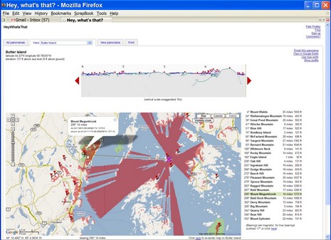
Where is this bubbling geographic/Internet stew going to take us (like EarthNC), and, in particular, what the heck else is being created nearly under my nose (like ActiveCaptain)? The latest is a rather amazing service created by one Michael Kosowsky out in the Lincolnville hills west of Panbo HQ. It began with Michael wondering what distant bumps he was seeing from his yard and now--much programming later--he's inventor/proprietor of Hey, what's that. Check it out. Right off the bat you'll see what's what from Mt. Battie, which happens to be where I took the header photo of Camden Harbor above. You'll see it centered in Google Maps with each visible peak marked by an icon, along with a panorama view above and a list of the spots to the right, each interactively clickable. But you've just gotten started.