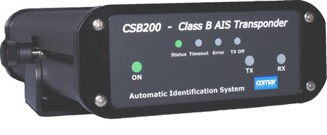
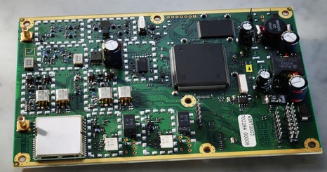
I think that at least three AIS Class B transponders are now fully approved and shipping in Europe, or darn close to it. And I believe that all three are based on Software Radio’s PCB (below). Interestingly the Comar CSB200 has changed since first pictured here. Note the “TX off” LED; two contacts on the back let the user rig an optional switch that will put this unit in Silent mode. Comar, unlike SevenStar, has not chosen to utilize the optional Safety Related Message (SRM), arguing that even some Class A AIS units can’t read it yet, let alone the shoreside authorities. These are some of the differences possible while still using the same core SRT transceiver. Hopefully, the good people at Trueheading, Y-tronic, Shine Micro, and elsewhere will fill us in on others. The Comar, by the way, was selling at METS for about 600 Euros, plus another 100 for an active GPS antenna, and you’ll need a VHF antenna too (hopefully tuned for AIS). Meanwhile, here in the States I’m told that USCG and FCC approval is still pending, subject to issues concerning “MMSI assignment, full transponder ‘Activation’, exclusive use of AIS I and 2, inland waters, and satellite monitoring, just to name a few.” Sigh.
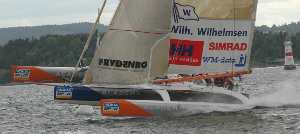
I may seem hung up on Garmin and NMEA 2000, but actually METS was worth months of future Panbo entries. For instance, the world introduction to the B&G H3000 system and also to Navico, the new “papa” brand over arching Simrad, Lowrance, etc., was wonderfully prefaced by extreme racing sailor Knut Forstad. Besides showing some stunning video of Volvo 70’s (100% B&G equipped), he had this slide illustrating an automatic sheet release system on a trimaran. Those Harkin cam cleats can be pneumatically opened by a Hercules processor based on any parameters in the system, like heel, pitch, wind speed, etc. Nice for a single hander trying to rest at 30 knots plus! After the press conference I asked Knut if offshore racers are using AIS. He told me that the Volvo Brazil picked up a receiver in Baltimore, loved it, and that many of the open 60 tris are now carrying full transponders. He was adamant about how valuable a technology it is, and how every offshore race boat should be carrying one. I learned a lot about AIS Class B at METS, but it will have to wait.
I believe the hip hop expression is “baby’s got back!” I like this rear view, bigger here, of the new Garmin 4xxx for both its industrial design sleekness and the implied power of all those connections. The three MarineNet (Ethernet) ports, for instance, are a new feature which means that simpler systems—say sounder box, radar, and XM weather/audio—won’t need a hub (though note that one is still possible, and advantageous in multi display setups). But what’s truly lovely is this standard plug—NMEA 2000 straight up, no patch cables, no “GarBus” or “GarNet” nonsense to confuse everyone. I also learned today that the rumor I repeated in that same “nonsense” entry was wrong: Lowrance is soon going to put standard N2K connectors on its LowranceNet displays and cables. Yo!
Unfortunately, a worse rumor is surfacing. Twice in the last week someone has asked me something like, “Is it true that theU.S. Coast Guard has some objection to NMEA 2000.” Well, I have more research to do but I very strongly doubt that the USCG has a problem (in fact, it was actually one of the earliest and strongest proponents of the standard , because it’s more reliable and hence safer). While there may be a little bureaucratic nonsense going on behind the regulatory scenes, I’m confident that it will not become a true problem. Especially so as today I attended the first ever European Connect Fest, where some 17 manufacturers with 42 different physical devices all shared data on the same backbone, and a lot of trade folks got down with it. Yo!
That’s a hand built prototype and not all the software is done yet, but there’s no question that Garmin’s totally refreshed marine line is major news for boaters everywhere. Notes on the image above, bigger here: * The casing is now aluminum and looks far better than this funky photo indicates, and the 12” screen seems very bright and color rich, even though the suggested retail on the 4212 version—with all U.S. charts, and now Bahamas Explorer charts too, built in—is about $2,670. * A lot of 3000 series buttons are gone (there really were too many), replaced by eight vertical soft keys. So many potentially wide soft keys mean that labels can be thorough (and easily multi lingual) and menu trees simplified. Note on this specific screen how panning onto a POI automatically suggested the info you access under it (that’s what I’m talking about!), and how there’s a “Stop Panning” soft key instead of the old Quit button that confuses so many new users. * The optional, now SD card based, g2 Vision charting shown seems to nicely mimic or improve on many of the features pioneered by Navionics Platinum and the Raymarine E-Series, like variable blend photo overlays (land only or land&sea), street overlay, 3D etc. Garmin adds a 2nd lower resolution world photographic base map (as does C-Map’s Max Pro), and an underwater 3D view that incorporates sonar. * While not ready for demo yet, Garmin’s new “Auto Guidance” sounds like a smart compromise. You simply choose your destination and the unit will search for all ‘safe’ passages based on your parameters. It will mark those boundary fashion but it will not create waypoints, which might be just too automatic.
I need to get back to the show where there’s something like a 1,500 other exhibitors, but there’s lots more to this story, even more new products than Garmin mentioned yesterday. For instance, how about this first ever 18” 4kw radar—which, like their others, does all its processing within and outputs via Ethernet, and which will retail for only $1,000. Hot damn!
Well, Garmin (having quite a week) didn’t mess around, releasing marine 2007 preview dope before METS opens its doors. Even an elaborate Flash presentation. Key features at the new 4000 series high end: 12” XGA screen, NMEA 2000 compliance (big news for the protocol!), support for new g2 Vision charts with worldwide satellite imagery and under/over-water 3D, and a brand new interface, including simplified “navigation with Auto Guidance.” A hands on look later, hopefully.
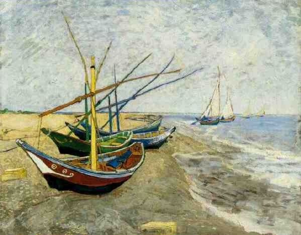
OK, watch me spin Vincent Van Gogh’s Fishing Boats on the Beach at Saintes-Maries into an electronics entry. You see I spent the afternoon getting to know the neighborhood around my B&B, which included a inspiring visit to the Van Gogh Museum. Later I was a bit surprised to find that the Museum’s fine site does not have images of his paintings, but instead links to the work of a passionate Van Gogh enthusiast. That’s what I’m talking about in regard to boating POIs; there’s got to be better ways to electronically share the exploratory work of enthusiastic cruisers. And, by the way, the placard that goes with the painting—which, of course, is much more vivid in reality—notes that Van Gogh thought these boats as beautiful as flowers, and that’s saying something. On a totally different note, though equally abstract, are Amsterdam’s pedestrian walk lights. When you push the button, you hear a clicking noise, not obnoxious, but loud enough that you know the thing is working. Then, when the walk sign goes green, the clicking increases, terrific for vision disabled folks like my mom (trying to get around NYC). It goes into my file of interface nuances that really work.
Speaking about how terrestrial navigation, at least in some ways, is now informing marine navigation, the big kahuna of non-marine GPS yesterday opened a fantastic looking flagship store on Michigan Ave in Chicago. It looks like Garmin took a cue from Apple—not a bad idea—creating many thousand elegant square feet where you can try all their gizmos, ask questions, take seminars, etc. Shoppers as passionate about GPSs as they are about iPods? Yeah, man! Which is interesting. When I bought my Garmin 45 in, what, 1993 (when did that beauty arrive?), I already knew a lot about navigation, like most every other fool who’d ventured over the horizon. Boaters broke GPS! There were years there where I was proselytizing handheld plotters first to my hiking friends, then to my long distance driving friends. But the shoe may soon change feet. I’m not sure that our children—weaned on geocaching, location-aware cell phones, arm bands that plot their jogs on Google Earth, who knows what—are going to sit on our knee for a nav lesson. “Hey, pops, do you mean to say that box you paid so much for won’t figure out your route, show hi res photo maps, or connect to the Web for user dock’n’dine recommendations?”
At any rate, I was honored to be invited by Garmin to the store opening—as a representative of old guard, I guess—but I already had other plans. I just arrived in Amsterdam for METS (starts Tuesday). In fact, I’m looking forward to seeing some new marine machines that Garmin is supposed to preview, but am also hoping to check out the POI advances on their car navigators and PNDs (Personal Navigation Device). I too just recently heard the term “PND”, but I’ll bet it’s not the last time.
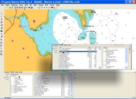
I’m working on a column about the “Points of Interest” we get on electronic charts these days. I think they have wonderful potential, but these days are often inaccurate, plus hard to use. Above, and full screen here
, is an example of an interface that seems to work pretty well, Fugawi ENC’s new ability to work with Navionics Gold+ (Platinum too, but many features aren’t supported yet). Note on the inset how you can easily search for harbors and marinas by distance from your present position, or (inset) narrow your search by multiple service criteria. Some other charting programs, and particularly plotters, are clumsy to search, lead you to empty data screens, etc. Plus, like every other electronic chart I’ve seen (all available, I believe), there are numerous errors/ommisions in the POI location and details presented here. Where, for instance, is info on the Camden Public Landing, possibly the POI of highest interest to visiting boats? So I have some questions for you all:
* Do you use electronic POIs when boating, or do you prefer printed guides, or both, or do you just ask around? * Which electronic charts have you tried and what’s good or bad about each’s POI data and the particular interface used? * What’s the future of POIs. I see a lot happening on land—like automated (Bluetooth) POI calling, user generated POIs and georeference photos, sites dedicated to sharing such info, etc. Not to mention Google Earth, Microsoft Live Local, etc. How and when will these advancements come to boating?
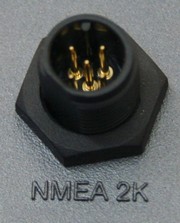
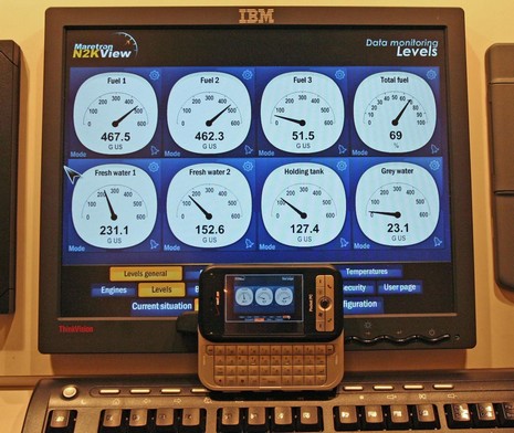
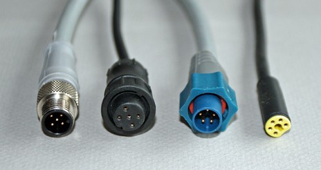
The screens above, bigger here , show Maretron’s prototype for N2KView, an engine (and more) monitoring program. Of course it handles most any raw NMEA 2000 data in a boat’s backbone, including J1939 engines via Maretron’s gateway. But an extra neat feature is that N2KView is actually a server, able to deliver the goods to all sorts of Flash clients, including that WiFi enabled phone. Perhaps even happier N2K–wise is the news that Carling Technologies—the substantial old line manufacturer of switches, breakers, etc (and owner of Moritz Aerospace, i.e. Octoplex)—has just invested in Maretron. And soon I’ll be able to tell you about another big brand that is adopting NMEA 2000. Could we be reaching a tipping point? Heck, even some of the habitues of Google Groups are having an intelligent conversation about its costs (for a change). But I also just finished up an N2K feature for Sail, and this morning took this plug picture below. Left to right they are NMEA 2000 standard Micro size, SeaTalk2, LowranceNet, and SimNet. They all do the same thing with those 5 pins, and all could have the same name! (I also heard that Lowrance may not change plugs to the standard as promised {a rumor later shot down, thankfully}). Patch cables work but this confusing nonsense has really set a good multi-manufacturer data standard back. If you too want to see the tipping sooner than later, complain!
I’d bet there are 100’s of blogs like these out there—wonderful for tapping into boat passion, and wells of useful info—but Jeff Siegel is a man apart. For years now he has been collecting and sharing valuable information on cruising communications (mostly via Trawlers-and-trawling). Last summer, for instance, he posted a thorough entry on his cell amp testing, and now has just posted his cell and WiFi experience during that 1,000 mile coastal trip. I recommend reading the full posts, but here are some highlights:
“My general finding is that WiFi isn't worth the effort of all the special hardware any longer. This is a sad conclusion. I've been using much of this WiFi hardware over the last three years with stellar success in the beginning. …My story isn't all bad. In fact, my "connected boat" experience during the last five weeks has been the best experience that I've ever had with being connected on the water. Where WiFi has fallen off, cellular has picked up the ball with amazing results. I maintained a continuous Internet connection WHILE UNDERWAY from Maine to North Carolina except in one 25 mile spot. This included sections where I was offshore: Maine (3-10 miles), Boston (12 miles), Long Island (10 miles), New Jersey (4-5 miles). The only dead zone that I experienced was along most of the Alligator-Pungo Canal in North Carolina.”
Good news, eh? Jeff will do more testing in a few months during leg two to the Bahamas (plus he continues to work on the next, very interesting, iteration of Activemap). His cell set up, by the way, is:
PS And how about V.I.V.A., the online log of a Vinalhaven voc ed teacher sailing to Florida and back with some of his students, and some comms gear Jeff helped spec out (small world).

 hose Harkin cam cleats can be pneumatically opened by a Hercules processor based on any parameters in the system, like heel, pitch, wind speed, etc. Nice for a single hander trying to rest at 30 knots plus!
 d XM weather/audio—won’t need a hub (though note that one is still possible, and
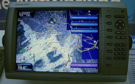


 Where WiFi has fallen off, cellular has picked up the ball with amazing results.