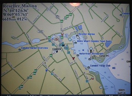
Garmin G2 cartography was announced in November, more detail came out in March, and now I’m actually looking at it, both versions. Yes, remember that G2 (or g2, as Garmin spells it) comes in two tiers. The 3210 I’m testing has G2’s of the whole U.S. built in; they are full detail charts with added major roads and some port info. But you have to buy and insert a G2 chart card to get all the photos, full street maps, and multiple POI’s seen above, and bigger here
. Pulled back a bit you’d see that there are about a dozen photos just for Camden, which rather amazed me. Some are oblique, some straight down, many are higher resolution than you’ve ever seen in a navigation product before. For instance, I can make out my 14’ Gizmo tied up in the shot below (bigger here). Garmin has a ways to go to make all this photographic wealth easily accessible—like making the icons more indicative of what the picture shows, and making it possible to page through all of a port’s pics without going back out to the chart—but I’m sure it will happen. I also see a few errors in the port data but that’s nothing new. For instance, almost every electronic chart shows Willey Wharf and the Camden Town Landing as one place with a common phone number, but they are quite separate operations (there’s either been a lot of copying or data licensing going on). Also “Reseller Marina” is completely new to me and I’ve been in this harbor for 35 years and am on the Harbor Committee! I’m looking forward to trying the 3210 and G2’s, both versions, on the water soon. (The cards, by the way, retail for $215 in Garmin’s regular sizes, and $321 in large sizes. And speaking more generally of chart data sources I was interested to see this list of hydrographic offices including what Garmin has signed up for.)
“Honey, I think that man down there kneeling on the water taxi float is drowning a cell phone or camera or something!” I must have looked weird trying to see if this borrowed Olympus Stylus 720 SW really could survive a salt water dip. I took pictures underwater (of murky Boston Harbor), rinsed the thing off under the tap, above, and… it’s still working fine. That’s impressive, and very nice to have around a boat (tip of the hat to Eli Boat, where I learned about it). But I’ll leave the extensive reviews/feature lists to the pros at Steve’s Digicams, Digicam Review, and Digital Camera Info—so I can just bitch about some minor issues:
* Why would Olympus use what seems to be a proprietary mini USB plug? That’s it at right (photographed with the 720 SW) next to a normal mini USB plug which works for my Canon XT camera and all sorts of other devices. And why couldn’t its relatively small battery be charged via the USB cable (like my new Motorola phone)? At any rate, owners of the 720 SW do have to drag along a special interface cable and a charger that’s bigger than the camera.
* While the 720 SW has lots of shooting modes—some very specific and useful, like shooting through glass (changes how the autofocus thinks)—it does not let you use traditional camera settings like shutter speed and F stop, which traditional photographers (like me) may find quite annoying. It also has no view finder at all and, though the LCD is brighter than other digital cams I’ve used, its still hard to use in bright sunshine.
* Finally, like the folks at Digital Camera Info above, I wasn’t all that tickled by the quality of the photos the Stylus took. Below, and bigger here
, is one of the best (a 2 photo collage, actually, showing the view from my roof). But then again, I am used to a very good digital SLR; I suspect a lot of people will be pleased with this camera’s performance, and especially its ability to take abuse.
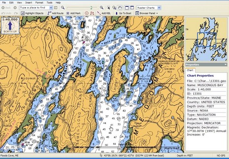
I took my first Maine boat ride of ‘06 yesterday (yahoo!), launching my 14’ power cat Gizmo at Broad Cove Marine Services in Bremen and exploring Hungry Island. The salty Maine expression for waters like these—i.e. lumpy with lots of hidden ledges—is “bony”, and I was a bit frustrated navigation wise. The only plotter screen onboard (silly me) was a tiny, poor-in-direct-sunlight Magellan. We did have a paper chart, but it was the reduced Waterproof Chartbook version of the most detailed available (1:40,000 scale), handy but hardly good enough in place like this where you where you really wish there was a high detail chart, like 1:20,000. At any rate it got me thinking about the SoftChart color palette I spoke of last week. Check it out: here’s full screen of the SoftChart above, and full screen of the standard NOAA RNC below. Don’t those rich colors clarify some of the important cartography? I wonder if Maptech will adopt these colors for paper as well as digital charts? I also wonder if the company will expect premium pricing for more richly colored charts?
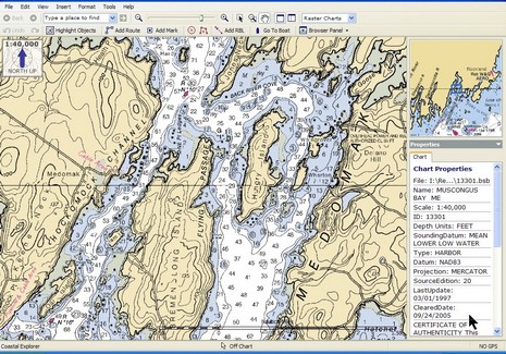
Note to Coastal Explorer/CNP users: did you realize that right mouse clicks neatly change the scale of the chart overview window (as shown)? And finally, for a nice picture of Gizmo at Hungry Island, click here.
This headline got my attention in yesterday’s Boston Herald: “Tanker may be blown up to test Harbor worst-case scenario.” Besides a general boyish interest in things blowing up, this story of course involves the LNG tankers that motor right alongside downtown Boston (and my temporary apartment) en route to their terminal. Their theoretical explosive power is truly awesome. The route wasn’t a great idea in the first place; it seems quite nuts after 9/11. The Coast Guard shuts the whole harbor down during the LNG transit, but what about a bad guy with a missile? At any rate, according to the article, “A major fuel company is in talks to blow up an LNG tanker in the ocean in a first-of-its-kind test that could answer questions about what might happen if one of the fuel-filled ships were attacked in Boston Harbor.” I couldn’t find anything more online but did come across this interesting page about LNG crews using a simulator of the Boston Harbor transit. I’ve seen a couple of these high end simulators now—one at Maine Maritime, and one at a Norwegian maritime academy—and they seemed like extremely valuable learning tools. I wonder if recreational boaters will ever get the benefits of something like this? Have a nice weekend, and steer wide of LNG tankers.
The May issue of BoatUS magazine has this “Action Alert”:
With no warning to users, the U.S. Coast Guard has proposed termination of the Loran system by requesting zero budget for Loran in its FY 07 budget request sent to Congress. This surprising development came with no stakeholders’ input and after the Coast Guard spent $160 million modernizing the Loran system, an improvement in signal strength, maintenance and coverage that is nearly complete.
Surprise, indeed! For years I’ve been telling folks that an improved Loran will return as a back-up to GPS. What gives? Well, I take solace in the rosy report currently on the opening page of the International Loran Association, well worth a read even if it predates the USCG announcement. According to the author—the inimitable and very credible Langhorne Bond, who I once interviewed for an article about GPS vunerability—Loran has proven itself the perfect complement to the satellite system for marine and aero navigation, not to mention precision timing (for power plants and much more). But he does note that fair allocation of the operating costs is an issue:
The Coast Guard pays the full operating costs and feels this is inequitable due to the future multi-model uses of LORAN.The Coast Guard is dead right, although the inter-agency discussion of this is likely to be gritty.
Gritty? Ah ha! I’m hoping that the CG budget surprise is not really about killing Loran, but about forcing other agencies to help pay for it. Still, we should all play our part. I’m taking BoatUS’s advice to write my congress people, only I’m adding a line about sharing the costs/giving the CG a break. I also plan to test the loaner eLoran I’ve been neglecting.
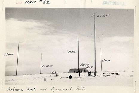
By the way, the picture, flushed out by Google images, is a Loran station on Attu in 1945. There’s even a bit of its history online. The USCG has been at this for some time.
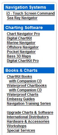
Yesterday we learned for sure that Maptech has acquired a bunch more marine navigation products, which must somehow be integrated with all the products it already sells. Heck, the long list at right doesn’t even include its latest offering. Here’s a peek at how it’s going to work as explained to me by Maptech PR manager Martin Fox and others:
* The Capn charting software—apparently the main impetus for this deal—will become Maptech’s commercial level product, with customization and fleet pricing available. Recreational users may be offered an easy switch to Chart Navigator Pro, and certainly won’t be left adrift. Dennis Mills, always the chief developer of The Capn, stays on as Product Manager (and is tickled about it).
* The SoftChart brand, on the other hand, will not survive, but some of its technology will. The plan is not finalized but Maptech may adopt some SoftChart features like its highly saturated raster chart color pallet (very effective on dim monitors) as well as a much less obvious “vertices” technique that improves chart quilting. Supposedly there’s also some interesting vector chart assets changing hands. Like Mills, Dick Davis—director of SoftChart cartography since 1995, and head of NOAA’s raster development team before that—is pleased about where his work has ended up, though he will not be working for Maptech.
* Maptech is “not sure” yet what it’s going to do with MarinePlanner.com, but I recall that the site has some interesting weather forecasting, trip planning, and other goodies (though they�re almost all locked behind a �membership� scheme right now).
* Finally, Captain Jack’s online and print catalogs will come back to life, but as an operation “totally separate” from Maptech. Fox must have used that “separate” word a dozen times, which got me laughing and is an indication that Maptech is a little nervous about annoying its own dealers. At any rate, the new Captain Jack’s “won’t look anything like a Maptech catalog” and its emphasis will be on “solutions”, i.e. bundles of products like, say, a GPS loaded with waypoints from an included ChartKit Book. I dare say it will also still include a nice collection of PC charting accessories, and that’s good.
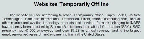
Another switcheroo in the business, and this one is complicated! Last fall, a huge outfit called SAIC bought IMAPS, which was a relatively short-lived conglomerate of small companies many of which had once been under the Pinpoint umbrella (and still are according to this antique site). Word had it that SAIC mostly wanted IMAPS’ military/aeronautics business and didn’t really give a hoot about the various recreational/commercial marine assets, which seemed born out by the apparent shutting down of Captain Jack’s and the enduring “temporarily offline” message above.
But now Nautical Technologies (makers of The Capn charting software) is at least partially confirming a rumor that’s been around for months now—that Maptech was acquiring some of the familiar brands that had been through the Pinpoint/IMAPS/SAIC mill. There’s some real irony here as certain of these assets were once Maptech’s most ardent competitors (there was even litigation). In fact, I was always a fan of Captain Jack’s print and online catalog of computer navigation products, which was quite complete except that it was missing all the Maptech products. Now does Captain Jack’s come back full of Maptech products? How will The Capn, SoftChart, and MarinePlanner.com fit with Maptech’s similar offerings? I’m hearing interesting things about all this, but am waiting for official word from Maptech.
PS I have spoken to Maptech; all the brands involved are confirmed; and come back tomorrow for more details.
On April 25th Brunswick formally promoted David Ritblatt from general manager to president of BNTME , and then two days later announced that BNT was for sale! How much did Ritblatt know and when did he know it? Why is Brunswick selling? Ritblatt responds to this general line of enquiry with some joking about being “in the dark” himself. I’m not sure about that, but I do see his point that as long as BNTME is healthy things are going to work out. Here are more aphorism-sprinkled points he made in our conversation last Friday:
* He stands by his MEJ predictions about developing an even closer relationship with Brunswick boat builders, “The planned sale of BNT Marine Electronics will not impact Brunswick’s strategy to integrate marine electronics. It is not necessary to manufacture Northstar and Navman products to integrate them into Brunswick boats.” Or: “You don’t need to own the cow to get a nice glass of milk.”
* He noted that BNTME just had its best month ever, including a 40% sales increase, and says he’s ‘honored’ by the many ‘interesting’ companies considering an acquisition. “They wouldn’t be hunting like this if the meat wasn’t tasty.”
* He did acknowledge a rumor I’d heard about delays in delivery of Northstar’s new 6100i series, but says they will be here this month (May), and that the 8000i will be delivered on schedule in June. The 6100i, incidently, is a juiced up version of the 6000i with support of Navionics Platinum charts and the new radar scanners which also work with the 8000i, and will eventually work (October) with the Navman 8120. The delay, he said, was logistical as manufacturing moved from Acton, Massachusetts to Auckland, New Zealand, which also resulted in price reductions. (There’s a sad aspect to that move, too, which I noted in my March column about BNTME, Ritblatt, and the 8000i—a column I just happily discovered is posted as a PDF at Northstar’s site).
* Ritblatt also noted that BNTME has a 100 engineers working on marine electronics products and what he thinks is the highest rate (% sales) of R&D investment in the industry. Finally, he gave me an impressive but off-the-record preview of products under development. There was an aphorism involved, but I’ve been asked not to repeat that either! Overall I’d say that while Ritblatt’s enthusiasm is no doubt part of his job description, his confidence in the future is pretty darn convincing.
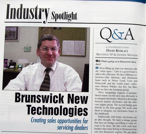
Today I did talk with David Ritblatt, president of Brunswick New Technologies Marine Electronics (BNTME). While he delivered no scoops about the future corporate home of Northstar/Navman/MX Marine, he was quite persuasive about how healthy his division is…and he was funny. But the details of all that will have to wait until Monday. Today I’ll just kid him a bit about his just published interview in Marine Electronics Journal (the NMEA trade publication pictured above). You see his predictions about the future of marine electronics might seem almost as faulty as mine in light of Brunswick’s decision to sell its marine electronics assets. For instance, right at the beginning of the interview he says, “We [Brunswick] are integrating engines—Cummins-MercCruiser—so the next step obviously is to integrate electronics…We work with them [Brunswick boat builders] to integrate our electronics better in the dashboard.” Then later, talking about the concerns of electronics dealers, “They see what Brunswick is doing. They see Raymarine is hooking up with Volvo or Yamaha. They see Simrad is buying Lowrance. I call it ‘polarization’. Camps are starting to be formed.” That’s sort of what I was thinking too, at least until last week. In fact, Ritblatt stands by his predictions and still thinks that his electronics will be closely integrated into Brunswick boats (and other builders too). More on Monday, including the humor.
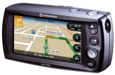
I don’t normally get into car navigation but this is an interesting idea, and it’s from a company that’s very much in Panbo’s radar. The Navman ICN750 above has a built-in camera meant not for snapshots but for easily shooting geopositioned photographs—dubbed NavPix—that you can later page through and select as go-to waypoints. Associated PC software and a NavPix Web site will even let you share such image waypoints with family, or the world. The press release quotes Navman USA general manager Chris Jensen thusly, “We tend to remember images better than we remember addresses. We all know what the Washington Monument looks like, but do we know the actual address? Most of us have commented to a driver at least once in our lives, ‘I’ll know it when I see it!’ Navman, NavPix technology and the global NavPix community set the new standard for navigation simplicity.”
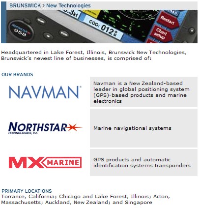
Would this idea apply to marine plotters, where the ‘addresses’ are even harder to remember latitude/longitude numbers? Hell yes. In fact, I think boaters will eventually get all sorts of benefits from the fierce competition for the potentially humongous automobile navigation market. However, that same fierce competition is why it makes some sense for Brunswick to sell off the land navigation portion of Navman; it is not, as they say, a ‘core’ business. But why is Brunswick also selling off Navman’s marine division, already separated into Brunswick New Technologies Marine Electronics (BNTME) along with Northstar and MX Marine? I have heard a lot of rumors and speculation in the last week, but no one really seems to know. Tomorrow I get to chat with David Ritblatt, president of BNTME, and that should be interesting!


 * Why would Olympus use what seems to be a proprietary mini USB plug? That’s it at right (photographed with the 720 SW) next to a normal mini USB plug which works for my Canon XT camera and all sorts of other devices. And why couldn’t its relatively small battery be charged via the USB cable (like my new Motorola phone)? At any rate, owners of the 720 SW do have to drag along a special interface cable and a charger that’s bigger than the camera.
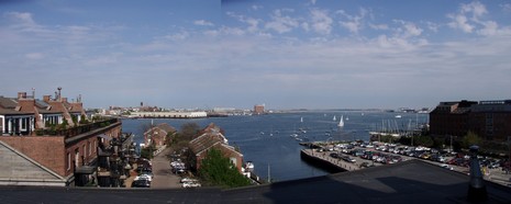

 Yesterday