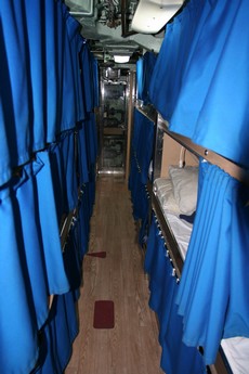
Above, and bigger here , is a ward room scene aboard the USS Salt Lake City last Sunday. It’s messy because the Portsmouth Naval Shipyard (quite a visit in itself) had already strung work lights in preparation for shutting down all the sub’s power systems. In the shot, Rich is telling the current captain, Cmdr. Tracy Howard, how in the 80’s there was a pull down screen where the big plasma display is now, and they played 8mm films from a projector in the pantry. It was just a cool coincidence that the junior officers happened to be playing that old b&w WWII sub movie as the ‘elders’ conferred.
All week I’ve been thinking about that sub, and what it must be like to crew one. Rich tells me that, even on a big one like this, there’s so much engineering that not every crewman gets a private berth (which are, ahem, kind of squeezed together anyway). I even rented a documentary, Submarine: Steel Boats: Iron Men ;(excellent), to get some more feel for it. It is crowded living. While sub technology may be amazing—this one went 21 years on one charge of fuel—even more so are the skillful, gentle men who run them.
Mike Slinn’s weblog sounds like a tabloid: “The dangerous secret about Raymarine radars that the manufacturer doesn’t want you to know.” Well, I read all the correspondence Mike posted and don’t understand at all how he’s come to the conclusions he has. It looks to me like various Raymarine people responded to all his issues—even though some are just RTFM (read the blanking manual) simple—and meanwhile Mike apparently hasn’t even taken their advice to update his firmware and check his power supply. I also question his concept of using this dinky radar, or any radar, to “catch up on sleep without compromising safety”. So what do you all think of Mike’s gripes, which he’s posting all over (like here, here, here, and here), and has anyone heard of another boat with this problem of a constantly resetting Raymarine radar scanner?
By the way, Mike is certainly not the first really, really unhappy marine electronics customer I’ve come across. Supposedly one went so far as to hire a plane to tow a derogatory banner over the Miami Boat Show a few years ago! Is this a particularly strong phenomenon in the world of boats? I think so, but not because marine electronics (or boats) are particularly poor…but because we care about them so much.
It makes more sense than you might think! That’s because so few plotters can yet display AIS targets, and a PC that can is often down below, too far from the helm for effective target tracking. Memory Map's PocketAIS will give a user audible collision danger alerts and/or sorted tables based on CPA or TCPA, as well as color coded target icons…all the normal AIS safety tools. And it could conceivably do all this wirelessly, as developer Richard Stephens often uses his creation, except that the nifty Bluetooth enabled NMEA mulplexers don’t yet do AIS speed (ShipModul is reportedly working on it).
Meanwhile Panbo friend Terry Sargent has been sailing around Malaysia some more, and has once again documented an interesting AIS encounter, this time while using MaxSea and Yacht-AIS software.
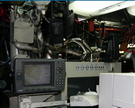
So I was excited just to get aboard the USS Salt Lake City; I can barely imagine what it was like for the 125 guys (+/-) who just cruised this technological marvel from San Diego, CA, to Portsmouth, NH, via the North Pole. Or what it was like for my dear brother-in-law, Richard Itkin, to be out there with the Russians back in the 80’s when he was the vessel’s first captain. You see my sub visit was a family event, and a sentimental one at that. Rich was on that conning tower above with his teenage son and daughter when the boat launched in 1982. What a kick then to show the controls to his 3 grandsons as the boat heads into retirement in 2006! The youngest, by the way (and bigger picture here ), is in the middle Diving Officer’s seat while the twins are in the Planesman’s (port) and Helmsman’s seats. Unfortunately, in terms of a technology tour, most all of the sub’s systems were shut down as it’s being prepared for reactor extraction. But suffice it to say that there are lots of places on the boat where the instrumentation is as dense as in this photo. Most of the gear is quite sub specific, but the Garmin plotter wasn’t the only COTS surprise. For instance, there was also Furuno sonar gear aboard, used during the last trip to look up at the ice, and judge its thickness. The USS Salt Lake City was able to find a thin spot and break through for a brief look at the North Pole. (Which makes Rich jealous; I would be too).
I knew the Navy used some regular marine electronics and even has an appropriate acronym—COTS, for Commercial Off The Shelf—but I was still amazed to see a Garmin 2006 tucked amongst the massive jumble of gear in the control room of a 360’ U.S. nuclear attack submarine. And what the hell was I doing on a submarine yesterday? More later.
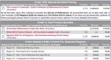
Oy, while I’m sleeping, a comments war breaks out over cheap charts (here and here). The main issue seems to be whether or not Maptech and NOAA’s free download sites are offering the same sets of raster charts, and therefore whether or not the various repackaging operations are offering the same chart DVDs. I don’t yet know the truth, but I am very dubious that Maptech is serving up a 1,000 more charts than NOAA is. Especially since the main source of this info seems to be a dubious site called FreeNavCharts.com. FreeNavCharts is offering a good service, and has lots of correct info about electronic charts, but, man, is it hyped up! Does a simple region of raster charts really have a retail value of $249.95, as suggested above? Hell no! Even when Maptech did sell $250 Digital ChartKit regions—before NOAA changed its chart policies—the package included much, much more than just the raster charts. And I’m afraid it gets worse at FreeNavCharts:
“It's interesting to note that Maptech still sells the BSB-3 charts in a collection called Chart Navigator Pro for $499.95. The 'Chart Navigator Pro' collection includes 13 DVDs. While this sounds like a lot larger collection, they fail to tell you that all of the BSB charts on the 13 DVDs could easily fit on a single DVD! They are packaged with 13 individual DVDs to liquidate leftover inventory of Regional Collections.”
I have one of the very first copies of Chart Navigator Pro (CNP) and can tell you that the charts are updated into November 2005. In other words, the “liquidate leftover inventory” line is pure bullshit. Moreover, I just opened a random CNP DVD—St. Augustine to Crystal River, Florida—and here’s what’s on it besides for the RNCs and ENCs: 1.2 GB of 3D bathymetric data, 688 MB of topo maps, 1.7 GB of photo maps, 70 MB of panoramic photos, plus tide tables, pilot books, and lots of POI’s. Of course CNP also comes with a copy of Coastal Explorer software, which makes accessing all this data very easy (and also makes FreeNavCharts’s much hyped index meaningless).
Bottom line: FreeNavCharts—like ChartsDVD.com, and I’m sure there will be lots more—is just packaging and selling stuff that anyone can download. The true retail value of the disks is quite low. Yes, repackaging is a perfectly honorable service because the downloading is a pain, but confusing consumers with hype—and especially with lies about another company’s products—is dishonorable. Here’s hoping the FreeNavCharts.com cleans up its act.
PS 1/7: As suspected, the 1,016 RNCs listed by NOAA are the same as the 2,077 RNCs listed by Maptech; it’s just a matter of whether you list, say, a 4 page small craft chart as 1 or 4 charts. My source here is Jack Webb, proprietor of FreeNavCharts, who plans to change his site to reflect this reality. Thanks, Jack!
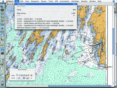
* Panbo reader Dan Hinckley has put together a thorough and useful review of his experience running both GPSNavX and MacENC on a Mac mini, which is where the screen shot above came from.
* A couple of readers have pointed out www.chartsdvd.com, which is the work of a sailing couple living in San Francisco. They’re offering all of NOAA’s free raster and vector charts on one DVD for $30, shipping included, nice and simple.
* At the other extreme of computer charting is WECDIS, the Warfare version of Electronic Chart Display and Information Systems. Slowly but surely the world’s navies are dumping paper charts in favor of WECDIS, or similar systems with different acronyms. The company supplying the British Royal Navy and hoping to get the U.S. business is OSI.
I don’t know anything about OptiMax, right, except that it popped up in our Google Ads when I wrote about touch screens. But I’m curious because I think screen cleaning is a serious subject! Last fall, when I borrowed PMY’s Luhrs to go up the Hudson, one of the twin Raymarine C-120’s at the helm had a really messed up screen, obviously the result of someone rubbing on the wrong fluid or with the wrong cloth. I’ve heard of Furuno NavNet screens being ruined with Windex glass cleaner. The point is that many modern marine electronics screens are surfaced with anti-glare coatings that are susceptible to damage. So how should we get the darn things clean? What do you use? Is it true that paper towels can scratch some displays? Have you ever checked your manual on this subject? Seriously, manufacturers and users, please tell us what works, and what’s dangerous.
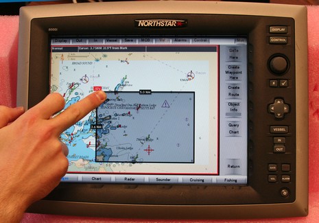
Touch screen does seem like “the natural interface” (as I just read at some promotional site), but there are two gripes about using it on the water: one, the technology can reduce precious screen brightness 10–20%, and, two, it’s hard to use when a boat starts bouncing around. Northstar has addressed both issues:
* The 8000i uses an unusual infrared touch screen technology; LEDs and photo cells hidden in the bezel create a invisible light grid which your fingertip interrupts. It seemed to work quite nicely during my demo and it doesn’t reduce screen brightness at all. Supposedly even gloved fingers and sticky fish scales won’t phase it. By the way, in the picture above (bigger here), the 8000i is zooming out by tapping a desired new center spot (red target) and dragging a box from lower right to upper left to define the zoom level. Left to right zooms in, the shaded borders let you pan, and all those touch keys can be hidden with the upper right ‘min’ button.
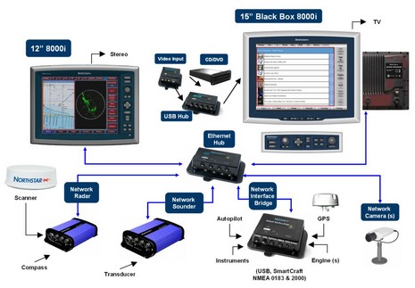
* But there are also zoom ‘in’ and ‘out’ buttons built right into the 12” 8000i, or you can plug in the dedicated key board seen in the system diagram with the 15” model, or you can use any other USB keyboard or pointing device. Interface flexibility!
This 12” unit, incidently, contains a 1.2 GHz processor and a 35 gig hard drive in addition to what seemed like a very bright screen, and it’s completely sealed. Yet, after a couple of hours of use, its relatively shallow aluminum back casing was barely warm, which I thought impressive, and a sign of durability.
The 8000i has a lot of sizzle, and some interesting new charts, but let’s start coverage with a system overview (bigger here):
* The sunlight viewable multifunction displays are Windows PCs; the 12” is self contained while the 15” is broken into monitor, processor, and keyboard modules. (Both units are also touch screen, but more on that later).
* This is a ‘masterless’ network, meaning that sounder, radar, cameras, and even the various sensor networks go directly to an Ethernet hub. If one PC is shut down, or craps out, it should not affect what the others can do. Several manufacturers have network black box sounders, and a couple have Ethernet radars, but this is the first time I’ve seen network cameras or a Network Interface Bridge (USB, SmartCraft, and NMEA 0183, with—hooray!—NMEA 2000 coming in the fall).
* The only exception to this ‘masterless’ design is that only one processor can be an entertainment server, burning CDs and DVDs with the built in ‘jukebox’ software. But then any display can play from the music and movie library at will, audio going to a nearby stereo and video either playing right on the 8000i screen or on a TV.
* All the parts shown, and the necessary cabling, are supposedly waterproof and marine tough.
Yes, it’s expensive—the 12” retails at $7,000–-but the 8000i looks like a smartly designed system, with a lot of redundancy, power, flexibility, and pizazz built in. More details to come.


 big plasma display is now, and they played 8mm films from a projector in the pantry. It was just a cool coincidence that the junior officers happened to be playing that old b&w WWII sub movie as the ‘elders’ conferred.
 me like various Raymarine people responded to all his issues—even though some are just RTFM (read the blanking manual) simple—and meanwhile Mike apparently hasn’t even taken their advice to update his firmware and check his power supply. I also question his concept of using this dinky radar, or any radar, to “catch up on sleep without compromising safety”. So what do you all think of Mike’s gripes, which he’s posting all over (like
  It makes more sense than you might think! That’s because so few plotters can yet display AIS targets, and a PC that can is often down below, too far from the helm for effective target tracking. Memory Map's
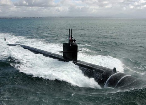

 I don’t know anything about