Late on Friday I learned that PMY is sending a crew of editors to the delayed Fort Lauderdale show. I sympathize with all the exhibitors and locals who don’t think the show should be run while the city is still recovering from Wilma (see PMY forum), but I’m also glad to be going. The electronics companies will have at least someone to show their new stuff to, and it will likely be so quiet that I’ll have a good chance to look it.
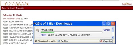
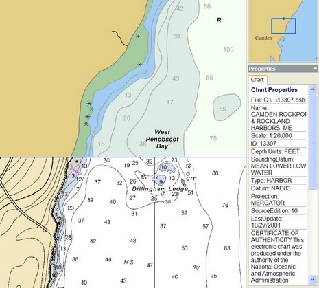
Rose Point Navigation just announced that Coastal Explorer is “the first program to include the entire NOAA chart collection covering all US waters.” What they mean is a sort of mulligan stew of cartography—500 ENC vector charts, 250 “Vector Coastal Explorer Charts” (which I think are actually derived from the DNC portfolio put together by NGA, the National Geospatial-Intelligence Agency, and also available from SoftChart for use with Capn 8.0), and 250 raster charts. In other words, they’re covering every bit of US coast at every available scale, but they’re not providing double coverage—raster and vector. By contrast, SoftChart is providing double and sometimes triple (two kinds of vector) coverage of many areas (at $200 per region), which can be darn useful for maximum detail and readability (I often cruise in Maine with both a vector and raster charts visible in split screen mode). I also noticed that CE has a little trouble perfectly quilting all three chart types, at least in my area, though below you can see how well it can do too.
But this is quibbling when you consider that Rose Point is including all 1,000 charts with its very able charting program, all for $400 total. The rasters will soon be on the shipping CD (DVD?) package, and are available for download now (though, as shown above, you need broadband). How did Rose Point get their mitts on these charts before NOAA has even started distributing them on its Web site? A good question, and the answer is about to reveal itself! And, by the way, can the worldwide portfolio of DNC vector charts, which seem to be downloadable, be used by the public? I really don’t know, but sure am curious.
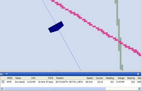
What's wrong with this AIS target, seen off Naples, Florida, a couple of weeks ago (with the Si-Tex receiver)? How about a bogus MMSI # (only 4 digits), no name, and destination as “HOME” (cute!) for starters. Plus the distances fore, aft, port, and starboard from the transponder’s GPS had been input as 10, 20, 30, and 40 feet (cute again, but impossible). That’s why Coastal Explorer—which, like many good AIS plotters, can properly size a target when zoomed in—drew the odd target icon above. But here’s the thing: even though someone had obviously done a half-assed installation of this transponder, it still plotted very smoothly down the coast, even though it was doing 25+ knots and I was only listening on one frequency with a crappy antenna. In fact I was able to get a visual on it when it went by the hotel and would guess it to be about a 32’ Tiara or something of the sort. How and why it had a $5,000+ Class A transponder on board I have no idea (megayacht tender?).
My notes on Class B AIS have prompted some interesting comments here and privately, so some more entries will be coming. But, for those of you less interested in AIS, be assured that I have lots of new product info in hand, and am testing some gadgets and software I haven’t even mentioned yet. Have a wonderful weekend.
As those of you in the industry no doubt know, there’s a lot of talk going around about the wisdom of trying to run the Fort Lauderdale Boat Show next Thursday, a week late. This afternoon PMY set up a forum to discuss the subject, or just vent. Like Panbo, you can post as yourself or under a handle.
Today, I’m afraid, we must speak of “frequency agility.” Part of the Class A standard is that transponders must be able to change channels if ordered to by the presiding local coastal authority. The digital command is received on the VHF DSC calling channel, 70. As mentioned in the past only one port is currently using this function, Tokyo, and I’ve heard that even it may turn back to regular channels 87B and 88B. Nonetheless, in September the U.S. apparently surprised international AIS committees by demanding frequency agility in the Class B standard. (This may have something to do with the still unsettled dispute with Maritel over use of 87B in the States, but, again, another story). At any rate, this change will mean that Class B transponders are more complicated and more expensive than originally conceived, and slower to arrive. Actual transponders available by the end of 2006 for around $2,000 is now sounding realistic. It’s also possible that there will be non-agile Class B transponders that are not approved for use in the U.S.
Now, as promised, let’s noodle a bit about what the Class B standard will mean. My thoughts:
• Some bigger yachts are going to opt for Class A—perfectly legal for anyone to carry—because they’ll decide that the additional power and priority, plus things like ship-to-ship messaging (not in Class B), are worth the added expense and install hassle.
• I’m wondering if a single frequency receiver will be effective, especially in close quarters, when it’s only getting dynamic data every minute at best. Real time tracking starts to get unreal, but maybe not enough to make a difference.
• Overall, Class B is going to greatly enhance AIS. Isn’t there a famous computer postulate that puts the value of a network equal to the square of its users? Isn’t AIS a more-the-merrier—and safer—situation, even for the lurkers (receive only).
PS. For more details of Class B, check out this page at Y-Tronic, noting that the Class B standard is supposedly going to use “Carrier Sense”, not “SOTDMA”.
Finally I have some specifics about the Class B AIS transponder standard, which is “very close” to finalization:
• Like Class A, static data will be broadcast every 6 minutes on alternating channels. A few fields, like destination, are missing but MMSI, boat name, call sign, ship and cargo types, ship dimensions, and GPS antenna position will all be sent.
• Unlike Class A, dynamic data will only be broadcast every 30 seconds (if the vessel is going over 2 knots, 3 minutes if slower). Again some items, like rate of turn, are absent, but MMSI, position, COG, SOG, and heading (optional) go out.
• Transponder power is limited to 2 watts, whereas the Class A max is 12.5 watts, plus Class B transmissions are ‘polite’. That’s actually a technical term meaning that the Class B time-sharing protocol (different from A’s, but that’s another story) will not slow down Class A in busy waters.
• Class B transponders are required to have an internal GPS, which will simplify installation as thus the only hookups are power, the optional heading sensor, and data out to AIS plotting devices. The 18” SeaLinks SL162B, shown, is an interesting (antennas included!) example of what the transponders will look like. I’m told that several other manufacturers are raring to go.
But there has been a recent change to the Standard that may slow down the Class B roll out and make the transponders more expensive, at least in the U.S. I’ll talk about that tomorrow, along with some noodling about what the above specs mean for single channel receivers. Your input is welcome, of course.
PS A big thanks to Fred Pot and Lee Luft, an analyst at the USCG R&D center (and an important figure in the development of NMEA 2000), for educating me about Class B. It’s odd that the comfy resort we shared breakfast in week before last is now closed due to Wilma. The latest on the Ft. Lauderdale show, by the way, is postponement to Thursday, Nov. 3, putting my Monday morning prediction almost on the money.
My good buddy Ben “El Geekalones” Ellison has graciously given me some space here in his MEB (Most Excellent Blog) so that I can alert you all to the doings of another good buddy of mine, Reid Stowe. Reid is setting forth next month (ETD is approximately Thanksgiving) on a record-breaking 1,000-day voyage aboard his home-built 70-foot gaff-rigged schooner Anne. He intends to circumnavigate the globe multiple times non-stop in the Southern Ocean, looping up into warmer climes when conditions and his mood warrant, and will also sail north to the equator and back each time he hits the South Atlantic so as to get credit for an official circuit of the globe.Reid has been planning this voyage for many years, and in 1999 conducted a 200-day non-stop passage as a test flight for this one.Now his boat is prepped and he is finally ready to go.
But he could use some help in the electronics department!To enhance the significance of what he’s doing, Reid is hoping to pull together a communications/transponder system that will permit him to document his voyage to the world as it takes place---both so folks can follow him as he goes along and to verify his accomplishment.
Anyone interested in lending some equipment, expertise, or service time to this project should check out Reid’s site (or call him directly at 212-414-4891).Reid will make sure you get credit as a sponsor if you like and will gladly participate in any reasonable marketing scheme you care to build around your involvement.A thousand days at sea, after all, is the ultimate test for any product/service.Or you can get involved just because you think it’s a cool project!!! — Charlie Doane, Editor-at-large, SAIL Magazine
PS. I too am a fan of Stowe’s 1,000 day sail, which I consider performance art of the interesting kind. And, by the way, Panbo welcomes guest blogs…of the interesting kind. — Ben
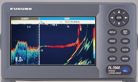
I first researched forward looking sonar (FLS) back in 2002, and later tested an EchoPilot Bronze on my 25' Ralph. I really, really like the idea of being able to see underwater ahead of the boat (I like exploring, and Maine is ledge city), but so far have to agree with the general consensus that the available gear--from Interphase as well as EchoPilot--can't see very far or with much detail. But now Furuno has introduced the FL-7000 FLS purportedly capable of seeing "up to" 1,600' ahead of your boat (though the image above, bigger here, only shows a breakwater, or similarly easy target, about 15 meters ahead). Just putting its name on FLS will bring new attention to the category, and I imagine there's some truth to Furuno's claim that it's spent years developing the "best FLS on the market". It's also the most expensive at something like $4,000 (though I haven't seen that in print, and there's nothing about it at Furuno's site yet). The unit also has something called "Baitscope Mode" that I don't comprehend yet, and is capable of using pitch and roll information to stabilize targets. And I'm told that the phased-array transducer, from Airmar, has tested successfully at speeds of 40 knots. Could the FL7000 protect a fast boat from, say, just-awash shipping containers? That would be something! Hopefully, I'll learn more at Fort Lauderdale, still on as best I can tell.
PS 9:30 am: Fort Lauderdale not opening on Sat., maybe not at all.
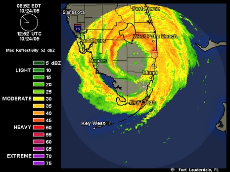
Monday, 9:00 am: on Friday afternoon the organizers of the Fort Lauderdale show postponed the opening from Thursday to Saturday, but I’m beginning to wonder if it will happen at all. As you can kind of make out in the radar shot above, Lauderdale is right now experiencing the worst portion of the storm’s eye wall. SSE gusts in Miami have hit 95 knots, and haven’t started to taper off yet. Wilma is moving fast, so South Florida will soon be able to assess how badly it got hammered. But even in good conditions the amount of boat handling, tent building, etc. that goes in this show is amazing. Of course the show is trivial compared to other problems Wilma is causing.
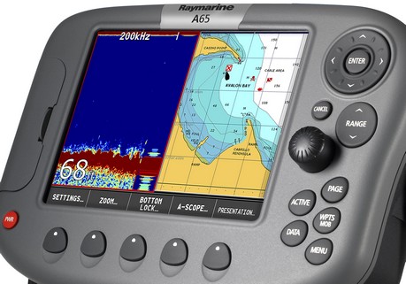
Next week in Ft. Lauderdale I’ll get an on-the-water demo of the new Raymarine A65 along with its included Navionics Silver chart card…so details then, apparent strategies now:
* The A65 is a 6.5”, though full VGA, plotter/fishfinder (or plain plotter) that seems to incorporate Raymarine’s crisp digital sonar technology and some of the friendly soft key interface seen in the C and E Series. It does not support radar, a high speed bus, or even SeaTalk2/NMEA 2000, but it does seem to offer some bigger boat electronics goodness in a smaller package (and price, though I don’t have the exact numbers just yet).
* The A65 comes with a Navionics Silver CF card that includes full detail coverage of the entire US coast. My understanding is that this signals the beginning of Navionics’ three tier chart strategy—Silver, Gold, Platinum…good, better, best. All the details aren’t out but the idea is that users of at least some machines can upgrade through the tiers as desired; meanwhile Navionics can move features down through the tiers as competition dictates. Slick.
The total package seems like a big “hello” to Garmin’s 192/198 series, Lowrance’s NauticPath etc., and also, in a way, to NOAA’s imminent giving away of all U.S. raster charts. (And a note to readers from outside the States: sorry that your governments are not pushing vendors to provide more and better chart coverage for less money, but then again you don’t have a powerful politician trying to gag your met offices.)