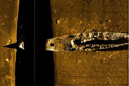
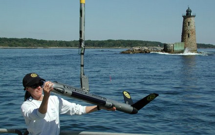
I’ve gotten fascinated by side scanning sonar, largely because products are coming to market that are inexpensive and easy enough to interest sport fishermen and amateur Captain Cooks. I’ll have entries on those soon, but first let’s look at what can currently be done with commercial grade side scanning, usually done with a towfish. Above is the wreck of the 291’ SS Portland, which sank off Cape Cod with great loss of life during a blizzard on Nov. 26, 1898. The image, which is not a photo, was collected with a Klein 3000 towfish (below). In the larger version, fish are obvious near the bow, which, incidentally, is actually attached to the rest of the boat (the black area is typical side scan distortion created when the gear moves along the track shown as a line). Bigger images and a fascinating description of the Portland disaster are here, and lots more scans in Klein’s gallery section.
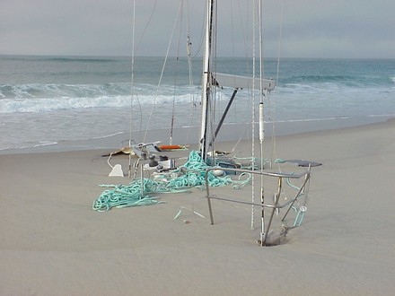
Above is the yacht Merrimac supposedly just days after fetching up on Sable Island’s notorious “swallowing sands” in 1999. The dramatic pictures (another here) started kicking around on the Web years ago, and I first saw them referenced in a snippy e-mail bemoaning the dangers of marine electronics. “A popular theory is that the autopilot was driven by the GPS and sailed a great-circle route, which took the Merrimac to more northerly latitude than intended.” I thought it was hokum at the time and wrote, “The implication seems to be that the operator of the boat was somehow gulled by his or her gizmos. I don’t think so. If the story is true that the crew hadn’t been checking their location on a chart, then the level of incompetence was profound. And traditional navigation can be done incompetently too (believe me, I know).” Now the current issue of BoatUS’s valuable publication Seaworthy (the “Marine Insurance and Damage Avoidance Report”) tells of a witness to the grounding who says the skipper had in fact plotted his Atlantic crossing on a paper chart and was right on course; the problem was that he used a hurricane plotting sheet that omitted Sable Island! In other words, what you see is the result of traditional navigation done badly.
By the way, I went looking for the obscure site where the pictures—even a graphic of the bogus great circle theory—used to live, and it’s long gone. BUT the amazing WaybackMachine has nine versions of the page as it evolved between 1/2002 and 10/2003. What a phenomenal resource.
It was an honor to be visited by Fred Pot last week. Fred is a Dutch marine engineer and consultant who’s been involved in AIS from the beginning. He currently lives on the West Coast, represents the U.S. on a couple of international working groups, and maintains www.uais.org. He’s also started a company, SeaCAS, that’s about to introduce the SafePassage AIS receiver he’s holding at right (with an appropriate background of Maine fog, bigger here). The whole deal is inside the fiberglass tube: a dual frequency receiver with an AIS tuned VHF antenna, and a 16 channel WAAS/EGNOS GPS with its antenna. The four wire cable can either attach via USB for data to a PC, and power from it, or it can go to a small interface box with a power feed and 38.4kb NMEA 0183 output to a plotter/radar or a mix of displays. It’s going to cost $1,250 when it ships in August, but obviously is easy to install and needs no accessories. Other features: a receiver sensitivity rated at -107dBm, the ability to pass along all AIS messages, and the incorporation of dGPS corrections when within AIS range of differential ground stations. I’ll try to post a note when there’s more information and live ordering at SeaCAS.com, and I’ll have more entries soon based what I learned from Fred about the state of Class B and some surprising ways AIS may get used.
PS Yacht AIS, mentioned earlier, has released a final version of its Professional level software and is also now offering it bundled with a dual frequency TrueHeading AIS receiver/GPS for 729 Euros (you’ll also need VHF and GPS antennas).
Update, 6/7: Fred reports that while he was travelling, his engineers were able to “vastly improve SafePassage’s sensitivity by changing its appearance”. The new design will still be all-in-one but with an exposed whip antenna on top of a shorter pipe. He promises a picture as soon as available.
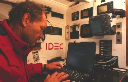
I can’t tell much about what he’s using—a small Furuno radar, B&G instruments, some PC program (MaxSea?)—but I do know that Francis Joyon is half way across the Atlantic and looking good to get the single handed record (better than 7d 2h 34m 42s) aboard his 90’ tri IDEC. Yesterday, he set a new solo 24-hour speed record of 543 miles! His site seems to be French only, but has great pictures. The one above is captioned “Francis etudie la carte” and was taken by Jocelyn Bleriot. Team Ellen is understandably keeping close track of Francis (in French & English); if he makes a new record, Ellen will try to break it in September.
Update, 7/6: Joyon took 22.5 hours off the transatlantic record!
Update, 7/7: Damn! Joyon elected to sail on alone to France after the finish, over slept, and totally wrecked IDEC on the coast of Brittany. What a strange single-handed mirror to the national joy of England getting the Olympics, immediately followed by the horror of terrorist bombs.
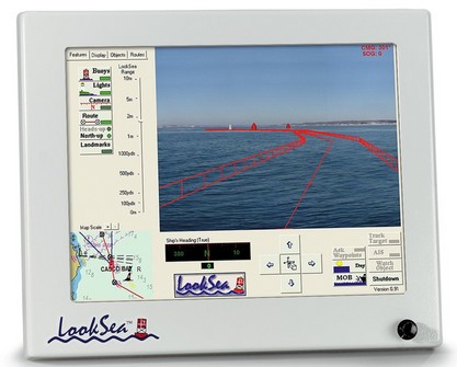
Never mind that Yme covered this Friday’s (mega) gizmo early last year. LookSea is truly unique, little known, and, besides, it was developed right here in the great state of Maine. What you’re seeing—larger image here—are a fenced route and buoy icons precisely superimposed on the video flowing from a pan and tilt, high resolution, wide angle camera mounted on the cabin top. ARPA and AIS targets, charted obstructions, and whatever else you need (and only what you need) can also be geopositioned on the live video. This is damn tricky to pull off accurately, and if it wasn’t done really fast, it would literally make you sick. I saw it demoed in a bouncy little boat on a snotty night, and can tell you that it works beautifully (fat .pdf of my article available here). I second the claim that LookSea is the “only augmented reality marine navigational system available and represents a quantum leap in safety and situational awareness.” It’s darn expensive, but I figure it’s a harbinger of things to come. (LookSea now a good step-by-step demo and other materials here).
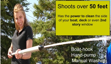
I’m a little concerned that readers who ordered the nifty Bridgenorth Bailer I touted a couple of weeks ago may not have gotten prompt service from the site listed. It turns out that boathookbailer.com is actually a U.S. distributer (there’s good news in this: the deal does include free shipping in the U.S.). At any rate, if you have any problems, here’s the Canadian manufacturer’s site, bridgenorthbailer.com, which is still somewhat under construction but has solid e-mail and toll free phone info, plus more dope on the product (including the compelling photo illustration above).

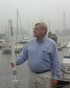 It was an honor to be visited by Fred Pot last week. Fred is a Dutch marine engineer and consultant who’s been involved in AIS from the beginning. He currently lives on the West Coast, represents the U.S. on a couple of international working groups, and maintains