
Merrimac, finally the true story
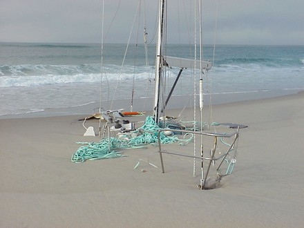
Above is the yacht Merrimac supposedly just days after fetching up on Sable Island’s notorious “swallowing sands” in 1999. The dramatic pictures (another here) started kicking around on the Web years ago, and I first saw them referenced in a snippy e-mail bemoaning the dangers of marine electronics. “A popular theory is that the autopilot was driven by the GPS and sailed a great-circle route, which took the Merrimac to more northerly latitude than intended.” I thought it was hokum at the time and wrote, “The implication seems to be that the operator of the boat was somehow gulled by his or her gizmos. I don’t think so. If the story is true that the crew hadn’t been checking their location on a chart, then the level of incompetence was profound. And traditional navigation can be done incompetently too (believe me, I know).” Now the current issue of BoatUS’s valuable publication Seaworthy (the “Marine Insurance and Damage Avoidance Report”) tells of a witness to the grounding who says the skipper had in fact plotted his Atlantic crossing on a paper chart and was right on course; the problem was that he used a hurricane plotting sheet that omitted Sable Island! In other words, what you see is the result of traditional navigation done badly.
By the way, I went looking for the obscure site where the pictures—even a graphic of the bogus great circle theory—used to live, and it’s long gone. BUT the amazing WaybackMachine has nine versions of the page as it evolved between 1/2002 and 10/2003. What a phenomenal resource.
Weird Web dept: Someone with the handle "Urinal Cakes" posted that old sunk-in-the-sand Merrimac photo on Redit, a commenter referenced this entry, and Panbo got more than 14,000 unique visits on Thursday and Friday instead of the normal 6,000. Of course they didn't stay long, and probably have no interest in marine electronics anyway, but I'll have a stat spike to explain forever.