It was bittersweet driving Charlie down to Spruce Head Marine to launch his Golden Hind Sophie. It was yet another gray day in this record breaking spring, and, besides, Charlie now lives out of state and had to jump in his car as soon as got Sophie onto her mooring in Rockland. But I did get a chance to see all the work that he’s put into the boat. The electronics — a slick Tacktick Sailmaster depth/wind system and an old Magellan 2000 XL GPS, both on a swing out arm — may be somewhat minimal, but the boat is otherwise ready go gunkholing or ocean voyaging. She is amazingly roomy for 31 feet, in a Brit sort of way, and Charlie put a nice new, and extra tall, rig in her. Sophie is for sale and will be a happy deal for someone, I think.
The croakers and rockfish just weren’t biting, but the research trip was terrific anyway. I’ll have more to say later about trying the latest incarnation of Maptech i3 and the Airmar factory tour, both very impressive, but today’s entry is about a little company you’ve never heard of called NSI (Nautical Solutions International). Google can’t find them but principals Mark Pringle and Floyd Phillips have been doing valuable, innovative (behind the scenes) work with 3D bathymetry since 1996. You may have seen it as contour modules in Maptech or Raymarine software, or as Bass Tracker on ESPN (and there’s more to come). Their web site is informative, but doesn’t show you how their office is right next to the marina where they keep two test boats ready to run year round. The latest, the Defiance 260 above, is totally tricked out with i3 gear; besides the big scanner, those are Weather Channel Marine and SkyMate satellite antennas up there. Such a deal: Maptech sponsors a great boat for showing off i3, which the lads at NSI also use to tweak the 3D fishfinder (and take a break from coding). Nice!
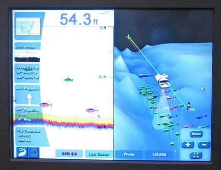
I’m on the road to Annapolis where I’ll get to trial Maptech’s wild new fishfinder module for its i3 system, maybe catch a croaker too. The poor photo above is of a simulation playing at the Miami Boat Show introduction. You can see on the left a regular 2D fishfinder screen while on the right the fish targets have been placed into a 3D bathy model; among other things, you can control how long targets stay on screen so that you can learn where fish hang out over time. Then on Thursday I’m visiting Airmar, source of the transducer and processor behind this module, and much more. My posting may get a little raggedy.
I have no tolerance for boaters who rip off electronic charts; the practice hurts decent companies and has understandably led to copy protection schemes the rest of us have to cope with. But one chart manufacturer, Nautical Data International (NDI), has earned its own reputation for pirate practices. It ticked off customers for years with extra high prices, flawed encryption code, and even a “time out” mechanism that rendered charts you owned useless after a certain period. Two years ago, a nasty royalty fight erupted between NDI and the two big chart card companies C-Map and Navionics. You see, in 1993 NDI somehow wrangled not only the exclusive right to market electronic versions of Canadian Hydrographic Office (CHS) charts, but also exclusive right to negotiate royalty arrangements with other vendors. Many lawsuits followed, some still in court, but last winter CHS announced that it would terminate its relationship to NDI. Hence the strange press releases featured on NDI’s home page (right) proclaiming its ability to continue “business as usual” and its success suing the government office it’s dependent on. I bring this up because I recently helped a friend prepare for a Newfoundland cruise and can confirm that charts he bought from NDI five years ago will not run or reinstall on his PC. He will use paper charts rather than ever do business with NDI again.
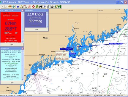
A reader from Sydney, Australia, wrote to say that he’s happily using a NASA AIS Receiver with a program I hadn’t heard of called Software on Board (SOB) from DigiBoat. I gave it a brief looksee, above and bigger here, and was impressed that SOB comes with a 15 MB C-Map world map that’s detailed enough for large area voyage planning. For actual navigation you need full detail C-Maps on a CD or memory card (which you can buy from DigiBoat, ergo the business model). On the other hand, it doesn’t support other chart types, and I found the interface a little difficult—no standard drop-down menus and oddities like those scroll bars in the data windows (probably related to my particular screen resolution/font setup). It’s totally irrelevant, but I also wonder if SOB is as common a swear in Australia as it was in the house I grew up in?
PS: SOB does require registration and a key to access all features, but it really is free at the moment (it may eventually become shareware).
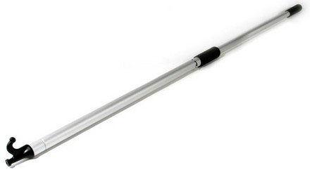
Friday bonus gizmo: you can lock the two part handle open to get a sturdy 5’ boat hook, or you can apply some pump action and suck the last drop out a bilge or dinghy. The fluid stays in the handle until you pump again, so the thing can also be used as a ‘manual’ power washer, or a wicked squirt gun. Or to test the CFR/NEMA rating on your electronics (there, topic maintained). It works like a champ and is so darn well made that I’m worried the inventor isn’t asking enough money for it. He sells them for $44 at Bridgenorth Bailer with free shipping (maybe only in Canada, the site isn’t clear). Have a good weekend!
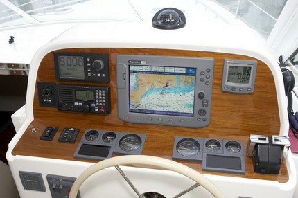
It was some fun getting a little wheel time on this Alden Brenton Reef 40 on Vineyard Sound last week. Despite bright sun and huge glass, you can see that the screen of the Raymarine C120 was up to the task. The radar overlay worked nicely too, and is much appreciated by the owner, who’s seasoned in boats and planes. I was there to write about cruising, not electronics, but presume that the C120 is getting heading info from the Simrad AP25’s compass via the fast version of NMEA 0183. You can also see (bigger here) an Icom VHF, an ACR pan & tilt spotlight, and ZF (Mathers) single lever electronic controls (whose delicacy took some getting used to). The owner laments that the E Series wasn’t yet out when he chose this rig, because he’d like to try the Weather Channel Marine satellite system that he’s heard will become an E option. And it shouldn’t be too long before fully electronic Yanmars and NMEA 2000 will create the choice of a second E in place of the analog gauges. The picture is courtesy my sharp shooting neighbor Jamie Bloomquist.
An on screen personality I am not, a fact I was reminded of yesterday when circumstances led me to some videos I did for PMY almost two years ago. I did try to be informative about Navionics Gold, above, even if I was terrified that the fancy camera bungee corded onto Gizmo would go overboard. Life was better with a real camera man for the shoot about DSC calling and plotting using Standard Horizon gear (still a way underutilized technology, I think). Plus there were stripers involved, which I’m pleased to hear may be headed to Maine early this year (thanks, Eli).
I joke about my often over-the-top test boat, but check this guy out! While the topophone looks like a sensible idea for improving our natural stereo audio reception (i.e., ears) so as to get better bearings on ship horns and buoy gongs in the fog, it must have freaked the passengers a bit. The image is the logo of a small company that’s developed a topo mapping application for Smart Phones. It appears to have some interesting features, like to ability to send/plot positions via SMS, but it also has a tough competitor in Maptech’s Outdoor Navigator.
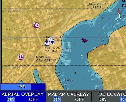
I’ve been getting requests to show more Platinum screens, so here’s one of what’s called Aerial Overlay. That means you can blend the regular vector charts with photo maps, which are straight down images that have been geopositioned so data (including your boat) can be plotted on them. Here the transparency of the photo map is set at 69% using the rotary knob on an Raymarine E120. Note how the photos improve your knowledge of what’s along the shore. Note too that the blending reveals descrepencies between the vector data and the photo map, a head’s up that one or the other is inaccurate. Platinum seems to include this resolution of photo maps for the whole U.S.; I understand the European version is lower res. Note too the camera icon, which shows you that there is also an “oblique” or “panoramic” photo available for this specific spot (wish we could all agree on nomenclature!). These are not geopositioned but do give you a useful perspective view of important inlets, marinas, etc. In Platinum they are quite high res (example coming).


 I have no tolerance for boaters who rip off electronic charts; the practice hurts decent companies and has understandably led to copy protection schemes the rest of us have to cope with. But one chart manufacturer, Nautical Data International (NDI), has earned its own reputation for pirate practices. It ticked off customers for years with extra high prices, flawed encryption code, and even a “time out” mechanism that rendered charts you owned useless after a certain period. Two years ago, a nasty royalty