Dan Fales has an interesting article on AIS use during last year’s Nordhavn Rally, and Maptech just posted a chart symbol test (actually a lead in to a new, and likely well done, reference guide).
If you go to the NMEA Web site and click on “NMEA 2000 Info”, the very first thing you’ll learn is how expensive it is to use the standard. These fees piss off small developers no end. (And isn’t it poor marketing on the part of NMEA? Why not have some good dope there about how the standard works and what it can do?) But the fees are there to finance the infrastructure needed to truly support a complex plug’n’play standard. For instance, I recently heard that updating the software certification tool that assures compatability will cost something like $200,000.
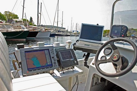
Meanwhile, I was out on Sunday checking out the benefits of that compatability again, and looking foolish. (Is there a geekier 14’ outboard afloat?) Now I have the laptop mounted, also sharing data fine, though currently the Maretron gateway translates 2000 into 0183 because no PC program reads NMEA 2000 directly. That’s going to change, and I’m told that eventually thousands of independent programmers will be using 2000 data to build boat applications we haven’t imagined yet.
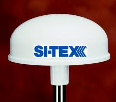
I like this: GPS backed up—plus made more accurate, even able to deliver better than 1° heading accuracy at rest—with LORAN! And this is LORAN without the fiddly complexity of compensating for “Additional Secondary Factors” in coastal waters or switching ‘Chains’ on long voyages. Si-Tex’s eLoran is not quite shipping yet, but I’ll bet it will get loads of attention (Chuck Husick already has this to say). In fact, we’ve all gotten so dependent on GPS that it’s a little scary. I wrote about its vulnerability, and the possible resurgence of LORAN as a complimentary system back in 2002, and have since noted the government’s funding of LORAN base station improvements. It’s great to see belt & suspenders electronic positioning come to recreational boating, not to mention the non magnetic heading sensor capability. Actually, eLoran is one result of a military research contract executed by Si-Tex’s mother company, Koden. Note that this initial product will only work with certain Si-Tex plotters and PC software at first, but other manufacturers will be free to add compatability. I’ve also been told that eLoran will cost about $1,000, and I plan to try one out when available.
Another Friday LED wonder: this shot of Lopolight’s production line suggests the extra high quality construction of these Danish-made navigation lights. The internal electronics are next potted in epoxy and a machined aluminum top plate finishes off the package. They are expensive but may indeed “work forever” on very little power. Note that you need to use Internet Explorer, not Firefox, to get beyond the home page of Lopolight’s Web site.
I’m back in Maine, but unfortunately won’t be able to make the Homecoming ceremony for single-hander Bruce Schwab that starts in Portland today. Bruce just sailed from France to Maine aboard his Open 60 Ocean Planet, which must have seemed like a day sail after two circumnavigations in three years, the second non-stop in 110 days racing the Vendee Globe. I understand that our Governor will declare today “Bruce Schwab Day”—kind of goofy, but wonderful to have this great sport better recognized here in the U.S.A.
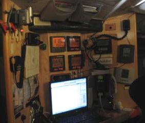
I particularly wish I could make Bruce’s “Truly Offshore Seminar” on Sunday, which will include a discussion of electronics and “trouble-shooting and repairs on the run”. I got aboard OP in 2003, after the Around Alone race, and know that Schwab removed the Furuno radar and fixed PC/monitors he had then in favor of a lighter laptop with a Nobeltec PC radar dome. Many people think such a setup unreliable but it apparently held up fine on the grueling Vendee course, though there was a problem with the scanner’s tilt mount mechanics. Bruce’s posts describing how he amazingly got to, and fixed, the mount while underway are here (look around 12/21/04).
I have an article about Navionics’ and C-Map’s new plotter charts in the June issues of both PMY and Sail, but unfortunately neither is online yet. C-Map Max is shipping and there are good images of it here, but Platinum—which by design, and pricing, is the more ambitious product—is still a mystery to most anyone who didn’t get a chance to see it previewed at the Miami Boat Show. Above is a screenshot of 3D mode, which really should be a video to do it justice. You can see (bigger here) that critical chart data like buoys and wrecks are overlaid on a composite of land photo maps and underwater bathymetry. The soft keys on the Raymarine E120, which will soon be the first plotter to display Platinum, indicate how you can adjust the pitch and rotation of your view. There’s much more. One indication of how much more is the fact that Platinum comes on 2 Gig Compact Flash cards!
Every year I get to pick five especially innovative and/or well executed electronics products for Sail magazine’s February “Editor Picks” section. Right now a top contender is Navman’s AP338 autopilot, not for performance (it’s darn hard to test autopilots) but because its interface is amazing. Almost any pilot can “dodge” an obstacle, usually 10 degrees per button push, but this one actually shows you what the commands are doing to your heading and what you can do next. There’s much more to this interface but I’m working with a flaky WiFi connection this morning, and busy, so for now I’m just going to link you to my writeup in June PMY.

 I like this: GPS backed up—plus made more accurate, even able to deliver better than 1° heading accuracy at rest—with LORAN! And this is LORAN without the fiddly complexity of compensating for “Additional Secondary Factors” in coastal waters or switching ‘Chains’ on long voyages. Si-Tex’s
 I’m back in Maine, but unfortunately won’t be able to make the
 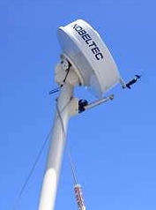 I particularly wish I could make Bruce’s “Truly Offshore Seminar” on Sunday, which will include a discussion of electronics and “trouble-shooting and repairs on the run”. I got aboard OP in 2003, after the Around Alone race, and know that Schwab removed the Furuno radar and fixed PC/monitors he had then in favor of a lighter laptop with a Nobeltec PC radar dome. Many people think such a setup unreliable but it apparently held up fine on the grueling Vendee course, though there was a problem with the scanner’s tilt mount mechanics. Bruce’s posts describing how he amazingly got to, and fixed, the mount while underway are
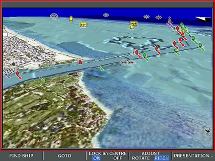
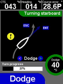 Every year I get to pick five especially innovative and/or well executed electronics products for Sail magazine’s February “Editor Picks” section. Right now a top contender is Navman’s AP338 autopilot, not for performance (it’s darn hard to test autopilots) but because its interface is amazing. Almost any pilot can “dodge” an obstacle, usually 10 degrees per button push, but this one actually shows you what the commands are doing to your heading and what you can do next. There’s much more to this interface but I’m working with a flaky WiFi connection this morning, and busy, so for now I’m just going to