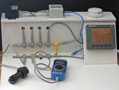
Hey, I actually can build something more substantial than sentences! Below is a plywood creation (bigger here) that will let me test the borrowed Maretron products (everything shown) and other NMEA 2000 gear either in my shop or clamped to my test boat, Gizmo. Note that all six devices shown not only share data through the rugged “Micro” size 2000 cable, but get power from it. That yellow wire is the 12v tap, supplying up to 4 amps to each side of the trunk line, which in this case is very short. Compass, 2000–PC USB gateway, GPS, and display are all on the upper or left side of the trunk. Depth/speed/water temp transducer, network test meter, and tees for the two plotters (separately powered) are on the other side. If I’d used heavier “Mini” size cable, there could be 8 amps available on either side of the tap. Putting together this little network was way easier than chopping up the plywood but there are details, like the Terminating Resisters at the trunk ends, you have to know about. Maretron has put together a useful “NMEA 2000 network designer’s guide” (and cable catalog) which is in PDF form here (if you just view individual pages, the guide portion starts on 17).
Last year Doug Ritter (right) and his Equipped to Survive Foundation (ETS) did the boating (and outdoors) community a tremendous service by uncovering performance problems in the optional GPS portion of PLBs and EPIRBs made by McMurdo. McMurdo subsequently offered a free upgrade to existing units. ETS now plans to test the upgraded beacons, as well as the latest models from McMurdo and ACR. If you’re in the U.S. and have an unused, but upgraded, McMurdo beacon, ETS wants to swap it for a brand new one and will even send you pre-paid shipping material. The deal sounds pie simple, and you’ll be helping to confirm for all boaters that the upgrade truly did the job. For an idea of how amazingly thorough this testing program is, check out these ETS Web pages. Update 5/17: Apparently Doug now has enough upgraded beacons.
Yesterday I plugged both a Simrad CX34 and a Raymarine E120 into a little network of Maretron NMEA 2000 gear…and, hot damn, both multifunction units immediately recognized and started displaying the available heading, GPS, depth, etc. info. No setup, no multiplexer, no fussing with 0183 wires—it just worked. The Simrad also had its own GPS attached, recognized that multiple GPS sources were available, and let me choose, via a thorough set of interface menus, which one to use (see below, and bigger image here). Easy redundancy, not to mention easy data sharing across a multi manufacturer network…this is good stuff. I witnessed, and wrote about, these capabilities last winter, but actually having my hands on 2000 gear is still exciting. More to come.
Me matey Charlie Doane just returned from skippering a New England to Caribbean delivery that included its rightful share of electronics drama. One night, sailing to windward and heeled down hard, he heard the “instruments down!” call from the cockpit. His first reaction — after yelling back “cope!” — was to nose around the power supply system, a whiff of sizzling circuitry leading the way. Low and behold, down in a low locker was a 24v-12v step-down transformer immersed in a puddle of saltwater that had apparently been collecting from a slight deck/hull joint leak that was getting a prolonged dunking. Electronics breakdowns, and other problems, tend to make deliveries challenging, and it’s telling that this was a seasoned 48’ Swan, the Mercedes of production boats. She’s been in service eight years, but apparently the little leak and the low gizmo had never interacted before. Another interesting aspect to this tale is that Charlie's crew were clients of Offshore Passage Opportunities, delivering the boat to learn offshore seamanship by doing. Not only did they sail on to Bermuda without instruments, but there helped Charlie locate a functional stepper installed elsewhere on the boat and swap it out. There were more invaluable lessons, including some fuel management theater, and I'm hoping Charlie will write up the whole trip for Sail.
One problem with putting together a high power marine WiFi system is the need to use finger-thick low-loss LMR 400 coax—the shorter the better—between the high-gain antenna and the radio. The stuff is hard to run and particularly ungainly when plugged into the dinky connector on a laptop’s PCMCIA card. One solution is a WiFi “Ethernet bridge” which can be installed near the antenna and then connected to the boat’s computer or network router via a slim, no-loss Ethernet cable. GeoSat Solutions has gone the next step by designing a 12v, 250 mW bridge into a waterproof box and packaging it with a 10 dB omni-directional antenna. This is a serious ($1,395) big boat system.
It’s a little confusing but note that one of these bridges—there are inexpensive non-marine versions—can connect to a conventional WiFi router. Thus a boater can use a normal WiFi laptop on board, connecting to shore via two WiFi hops. Here’s an interesting example of such a system installed on a Greenpeace vessel.
Friday gizmo: Davis just announced WindScribe, a $129 ultrasonic wind speed sensor that apparently uses some of the technology seen in Airmar's WeatherStation. WindScribe also measures temperature and computes wind chill, and can be mounted using an included bracket. There’s nothing up on the Davis Web site yet but it will probably go in this section of wind indicators. One thing I don’t understand in the press release is the gadget’s ability to “monitor maximum headwind, maximum tailwind, 5-second average and running average.” How can you measure head and tail winds without knowing your own speed?
In addition to Kees’ report yesterday, Dan sent in a link describing another successful test of the Nasa AIS engine, this time in conjunction with GPSNavX charting software for Mac computers. (Thanks, Dan, and I’ll follow up on your other Mac navigation suggestions soon). PC Maritime's interesting Navmaster Superyacht AIS package (look in the Leisure section) includes the same Nasa engine, which passed the company’s own testing and is reportedly pleasing early users. Superyacht’s AIS display looks like the best I’ve seen to date. Click here for the full screen shot and notice how the vessel is drawn to correct scale and its predicted track, i.e. rate of turn, is shown along with its heading. The user gets to control what data gets shown with the AIS target, plus the sidebar neatly categorizes all possible AIS info. I still want to know if there's a downside to only receiving one AIS channel at a time (I've asked Nasa), but it sure is exciting to see AIS hardware, and software, rapidly becoming affordable for even medium size yachts.
Update: “The same data is sent alternately on both channels so listening on one channel only is not much of a limitation. (It means the unit would 'hear' data every 6 seconds rather than 3 seconds from a vessel travelling at speed.)” — Nasa Marine
I’d never heard of this Nasa AIS “Engine” before, but oddly got two e-mails yesterday that referenced it. It seems almost too good to be true: a simple AIS listener that can feed ship information to a PC’s serial port for a mere $200 (plus cost of VHF antenna). It’s sold by a U.K. firm here, but does not seem to be listed at its manufacturer’s site here. One spec I see that might be a deal breaker is that a user must “Select 161.975 or 162.025 MHZ operation”. I thought AIS devices automatically use both. Please, someone, educate me on these mysteries!
Update: Be sure to read the comment from reader Kees who owns one of these listeners, reports good performance, and terms it an �outstanding no unbelievable value...� Thanks, Kees!
When Navionics Platinum chart cards come out this summer, 3D photo mapping will come to boat plotters. Platinum (still not much on the Web yet) is really going to turn some heads, as it did during the Miami Boat Show. If you want to see what the eventual possibilities are, take a look at NASA’s free program World Wind. It’s not quite as user friendly as Keyhole, but has higher resolution photography for much of the U.S. The screen shot above (bigger here) shows a Hilton in Clearwater Beach, Florida, where I’m attending a magazine meeting this week. In World Wind I was able to check out the beach and marinas, etc. before I got here. You’ll understand why posting may be irregular this week!
OK, I’m obsessed with charts, but I’m not the only navigator thus afflicted. Last week I used a snippet of a wonderful 1685 chart that’s available on the Net, and promised to tell more. The source is the U.S. Library of Congress Map Collection. The LOC has scanned scads of cartography at very high resolution for your viewing and downloading pleasure. You’ll see several categories, none of them “nautical charts” per se, but you’ll find all sorts once you dive into the search engine. Shown here, and larger here, is a bit of a 1921 chart of Miami. It’s interesting as an early example of color use, and also because it shows a Miami Harbor that’s damn shallow and missing some major features like Fisher Island and the whole cruise ship dock area.
You can zoom into the detail of these charts nicely on the LOC site, especially if you have a fast Web connection, but there’s a problem if you want to download one for further perusal or printing. Many are in an unusual format called MrSID that no standard graphic program I know of can read. The solution is IrfanView, an excellent freeware (or “beggar ware”) program created by a young Bosnian named Irfan Skiljan. IrganView can turn this 6.6 meg .sid file of Miami into a 90 meg .jpg file that would print nicely full size. The LOC offers some maps and charts for areas outside the U.S., but if there are richer sources I'd sure like to hear about them.

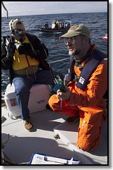 Last year Doug Ritter (right) and his Equipped to Survive Foundation (ETS) did the boating (and outdoors) community a tremendous service by uncovering performance
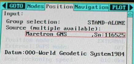
 Me matey
 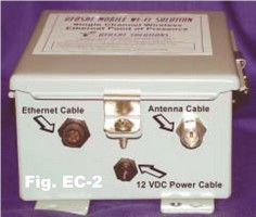 One problem with putting together a high power
  Friday gizmo: Davis just announced WindScribe, a $129 ultrasonic wind speed sensor that apparently uses some of the technology seen in Airmar's
 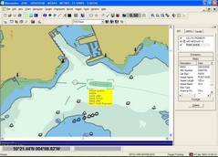 In addition to Kees’ report
 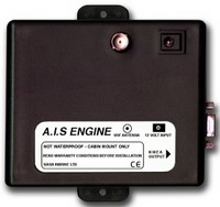 I’d never heard of this Nasa AIS “Engine” before, but oddly got two e-mails yesterday that referenced it. It seems almost too good to be true: a simple AIS listener that can feed ship information to a PC’s serial port for a mere $200 (plus cost of VHF antenna). It’s sold by a U.K. firm
 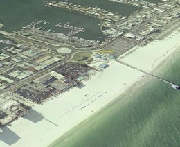 When Navionics Platinum chart cards come out this summer, 3D photo mapping will come to boat plotters. Platinum (still not much on the Web yet) is really going to turn some heads, as it did during the Miami Boat Show. If you want to see what the eventual possibilities are, take a look at NASA’s free program
 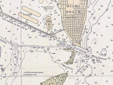 OK, I’m obsessed with charts, but I’m not the only navigator thus afflicted. Last week I used a