Navagear found a solid state bilge pump switch that can discriminate between fuel/oil and water, so presumably you will not pump the bad stuff overboard. I’m just a wee bit skeptical about how well this works in the real world. What if there is just a little oil swirling around your bilge; might the switch shut down when you didn’t really want it to? A while back I tested SensaSwitch (above), another solid state “float” switch that I liked a lot. It does not claim to “discriminate” against hydrocarbons but one reader wrote in claiming that oil films made it stick on or off, which of course is what no-moving-part switches are supposed to avoid (my test didn’t include oil!). The company tried to investigate the claim but the guy said he’d thrown the switch away, and his email went dead, so this report is very much hearsay. Does anyone out there have either SensaSwitch or Water Smart Switch installed in their boat?
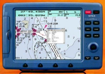
Yesterday I was tickled to learn that Nasa’s AIS Radar and Engine will be marketed in U.S. under the well known Si-Tex brand (thanks, Pascal). That means U.S. sales and support. It also turns out that the Engine will put up AIS targets on a variety of Si-Tex plotters, like the Color Max below (just a mocked up screen). This AIS listener business is moving fast!
U.S. Navy Submarine Captain Kevin Mooney takes full responsibility for crashing the San Francisco into a practically uncharted undersea mount in the Pacific last January. Yesterday the New York Times published a detailed story about the accident, particularly the drama of trying to treat and evacuate mortally injured Petty Officer Joey Ashley. Then CBS 60 Minutes did a “Who’s to blame” piece, which I happened to see. The interviewer drew out how Mooney was using a classified, best-available Navy chart and steering a route sent from headquarters, but still the Captain—who seemed like an very decent man—insisted that he should have been going slower, should have checked other charts (where there were just hints of the mountain). Most of all, he said, “I should have been more skeptical about the chart data.”
Those are words to remember, especially as there’s a growing disconnect between our super precise electronic navigation and the precision of the underlying chart data. It’s a phenomenon I wrote about here.
The super fine sailing newsletter Scuttlebutt is having a subscription drive, with benefits for all. If you aren't getting it, or know people who might enjoy it, for cripes sake do the clicks. The ‘Butt’ may be mostly about racing, with rarely an electronics reference, but it’s wonderfully written, covers many sailing subjects, and sometimes features stunning photos by the likes of Carlo Borlenghi (how does he do this, by the way…in a wet suit?).
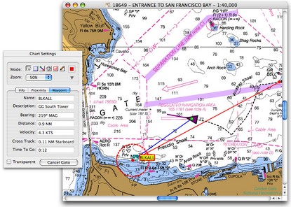
Correspondant Dan is psyched about the growing possibilites of Mac navigation for his 40’ sailboat. The starting point is GPSNavX, which offers a hell of a lot for $50, was extravagantly reviewed by Chuck Husick here, and will soon—according to Dan—support free NOAA ENC vector charts. Possible hardware includes a “Mac Mini, a normal 12-15" monitor for below decks, a sunlight monitor (like certain Big Bay screens sold by Tom MacNeil Electronics) for the helm w/mouse and buttons to control the software on the mini, BSB charts form Maptech, and a Nasa AIS Engine.” He also mentions a Mac compatible USB GPS whose links seem dead, but there are other choices; I like the looks of the USGlobalSat MR-350 cabin top model that can be bought with GPSNavX. Dan closes his description with that favorite Mac brag, “And, best of all: no viruses...” Us PC people are a little jealous about that, and about the Mini, which almost seems designed for a boat.
Seems-to-be-a-trend department: another correspondant, a true Uber Geek, wrote last night describing the elaborate system he’s putting together for a custom 50’+ power cruiser. “The helm support computers will be Mac Minis and the planning software will be GPSNavX, an insane value at $50!!”
Eli, proprietor of the often stimulating EliBoat, knows Maine waters and yesterday wondered “if the new charting programs will ever find a way to plot 6 trillion lobster pots.” His number is only a slight exaggeration; the pot buoys and their warps really are a navigation problem. Eli jests but I do hear talk of AIS transponders replacing RACON buoys at harbor entrances and maybe someday the tiny RFID radios supposedly coming to everything in Walmart will warn a boater of a dead on buoy about to tangle his prop. But in the meantime a sharp blade can do what electronics can’t. I tried this Hook Knife from Sailors Solutions last summer and it is wickedly effective.
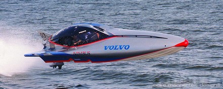
Yeeeeeha! The basic V-24 is a 26’, 360 Hp, 70 knot racer designed a few years ago by Ocke Mannerfelt, and said to be relatively ‘safe’ and easy to drive. Panbo reader Tom W. has a custom version sporting 650 Hp and capable of over 100k—nicely displayed at www.batboats.com. You can imagine that it gets noisy in there! He and his passenger currently use a full duplex “helmet intercom system made by PCI Race Radios that’s tied into my VHF radio with push to talk buttons in the dash for both driver and passenger.” He’d like to do away with the wires. Can anyone suggest a solution?
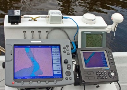
It was another damp weekend in Maine, but the leaves are popping and I finally got out on the water. The NMEA 2000 test rig performed fabulously. Check out the bigger image here to see how the Raymarine E120 and Simrad CX34 are both getting GPS, heading, speed through the water, etc. from the Maretron sensors. A PC charting program could have been easily sharing it too, had I dared bring a laptop along. At this moment I was drifting (speed 0, SOG 2.2; heading 85, COG 64) down the St. George River with…errrr…a rather high level of situational awareness. Both plotters were able to calculate current set and drift pretty accurately, and the Maretron display kept track of the little boat’s pitch, roll, and rate of turn. And I had even more redundancy than expected…it turns out that if I unplug the Maretron GPS, the E120 will switch over to the Simrad GPS that’s plugged into the CX34. The one glitch was the depth delivered by the Maretron transducer, much shallower than shown, but I’m sure there’s an explanation. Plus I had another sounder, not shown, and in fact the shoal area ahead is deeper than charted. And it’s a lovely river to gunkhole (click here for an experiment with Maptech’s chart server).
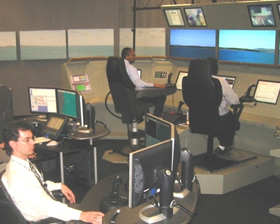
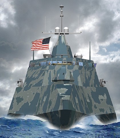
It’s hard to reconcile the somewhat goofy bridge scene above with the wicked looking warship below, but they represent the same yet unbuilt U.S. Navy design called a Littoral Combat Ship (LCS). Picture an aluminum and steel 127m (417’) trimaran capable of sustained “sprints” at 47 knots and tight manuevering—even in shoal water—with waterjets and steerable thrusters. While flying last week I met an enthusiastic General Dynamics engineer who gave me the Web address of this fascinating project. Of particular note to electronics geeks is the design’s “flexible information technology backbone that allows ‘plug and play’ integration.” Apparently the Navy has imposed “open architecture” requirements and GD’s solution “leverages industry standards and non-proprietary interfaces.” I guess that explains all the Dell monitors on the mockup bridge, and I wonder if they are using NMEA 2000? And wouldn’t the LCS design make a hell of a megayacht, though Larry Ellison—no relation—would have to settle for something shorter than his current ride. (More pictures here).
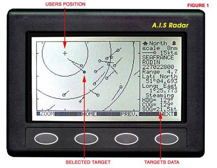
Yesterday Roger (a true DYI guy I’ve noted before) commented enthusiastically on Nasa Marine’s “AIS Radar.” It certainly does seem to provide a complete AIS listener for a very reasonable price, about $365, but I have some concerns. The main one is that Nasa “chose to simulate the plan position indicator (PPI) of a conventional radar display” (hence the name). In other words the target vessels are plotted relative to your own boat’s course and speed, not their true course and speed (though that’s shown in the data window). The goal is simplicity; a target on a collision course will generate a trail headed right at you. The problem is the plotting confusion possible when you change course or speed. Plus AIS Radar, like Nasa’s AIS Engine, only uses one frequency at a time—though that may not be an issue. And, finally, it does not support output to a PC. For more information, allGadgets has the manual posted here. Of course, my concerns may be unwarranted; I’d like to hear from users and/or try one myself.


 Eli, proprietor of the often stimulating