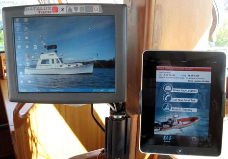
Gizmo is still ashore, but she shed her shrink-wrap this week and today I had a few enjoyable hours aboard tidying up and fooling with some new accessories. One is the handy mount holding the iPad up next to the Datalux police car computer (which apparently survived the winter aboard fine), but first let's talk about the free and very clever BoatUS smartphone app showing on the pad. Some of the features alluded to in that link aren't enabled yet, but its primary function -- making an automated call for a tow -- worked very well in my test...
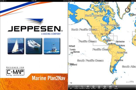
I only got a poor photograph in Miami when Jeppesen let us peek at the soon-to-come C-Map charting app for iPads, and so I'm tickled that they send over a selection of screen shots. While they're still not saying when the app will be available, I guess we should understand that besides the software itself they're also tasked with building a system that enables users to buy and download chart regions in what is probably a special format...
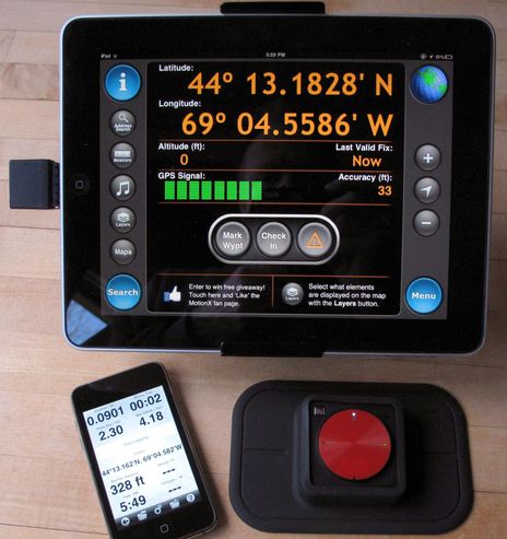
Over the last few weeks I've enjoyed testing two of the very few Apple-certified devices that can supply GPS to a WiFi-only iPad, as well as the iPod Touch. They are the Bad Elf, which is available at Amazon for $99, and the Dual XGPS 150, similarly available at Amazon for $100. The news is all good; both worked fine with every charting and mapping app I tried, which were many (a few here), and I think both validate the premise discussed when the Elf was first announced, that it's unnecessary to buy a 3G iPad just to get the GPS. I must say, though, that the Bad Elf might have better prospects if the Dual hadn't come along so soon...
It's a lousy photo, for sure, but Jeppesen C-Map has not yet announced its iPad charting app, let alone released screen shots, though I found it one of the nicest surprises of the Miami show. It seems that C-Map not only intends to match Navionics' much appreciated efforts to offer inexpensive but detailed marine cartography on multiple apps platforms, but to do it even better. Note, for instance, the "CWeather" button on the menu bar above, and that C-Map has been working to overlay weather data on plotters since at least 2004 (though the then available mechanisms -- a complicated cellular connection, or a data card transfer -- were awkward). I'm not sure what CWeather offers today (the Jeppesen site says only European data), but we do know that a connected tablet or phone can make the download process very easy.
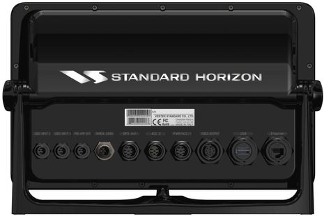
I wrote about Standard Horizon's new CPN series in December -- and in the current issue of Cruising World -- but now there's more detail up on the SH web site. I particularly like the booty shots of the 1010i and 700i because all those ports really speak to the technological convergence going on with this design. That's the theme I tried to weave through the February CW round-up of new electronics, which unfortunately isn't online yet, and had to be drastically cut due to space constraints anyway. But I'm getting a second chance, sort of, as I'm working on somewhat similar feature for the April issue of Yachting. It will still be shorter than the CW attempt, but it will be purely about how so many of the electronical things we do on boats are coming together, and how it's happening in such divergent ways...
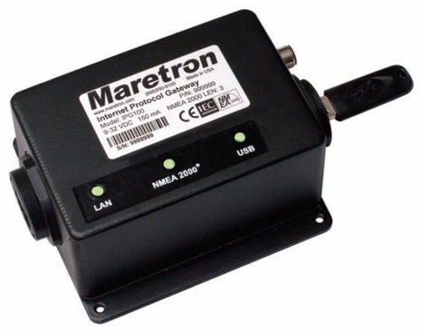
Wow, Maretron just released the IPG100, an "Internet Protocol Gateway" that can take all the NMEA 2000 PGNs on a backbone, turn them into TCP/IP data packets, and serve them out an Ethernet port. Which means of course that the data can then be routed by cable to a vessel's local network of computers (and other fixed Ethernet gear) and by WiFi to an infinite assortment of onboard mobile tablets, apps phones, etc. Obvious too is that an IP gateway could also be adept for sending data off a vessel, and commands back, for remote monitoring, troubleshooting, and more. And Maretron's IPG100 consumes only 0.5 amps of N2K backbone power at most and its $595 price tag includes much more than I've already described. Or possiblymuch less, depending on your point of view!...
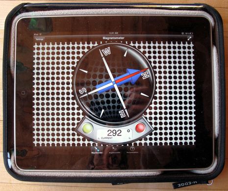
I find that my iPad is so sharp and slippery that I almost always use it in a case, and once I get it on the boat there will also be an increased danger of impact or water damage. So I've been testing three candidates for Gizmo's cruising iPad case. That M-Edge Leisure Jacket above is far and away my favorite at this point. Yes, it's a bit bulky but the high-density fitted-foam bed and cloth cover are light, easy to handle, and highly protective; and the whole thing tends to stay where you put it. Perhaps most important, the vinyl cover does not impede screen use nearly as much as you might presume. I've used the Jacket a lot now, with all kinds of apps, and I'm rarely annoyed by the plastic. The pocket on the back may be too tight to be very useful -- and I wish it had a "kickstand" for typing comfort (though it's easy to stick something under there to get the right tilt) -- but I like the Leisure Jacket. Now, about that weird compass app...
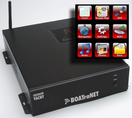
Interesting! Digital Yacht's BOATraNET -- just being introduced at the London Boat Show -- is a low-amperage 12v Linux server designed expressly to deliver all sorts of NMEA 0183 and/or 2000 boat data, plus centrally stored info and media, via WiFi to whatever assemblage of smart phones, tablets, and PCs are on board your boat. And you won't need a special app but rather just a new generation browser running HTML 5. You can also connect a high power WiFi transceiver to BOATraNET so that all your devices can get online via the boat's own hot spot when you're in port. Can anyone argue with Digital Yacht's characterization of this concept as "revolutionary"?...
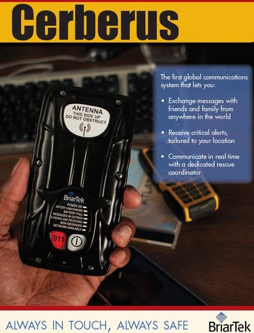
Yes indeed, if you're already wowed about how Globalstar's new SPOT Connect might help you communicate when you wander beyond cellular, you'll likely mumble multiple wows once you understand the abilities of the somewhat similar Iridium-powered Cerberus system. Click on that brochure cover above -- seen first right here! -- and behold the Iridium/GPS/Bluetooth communicator itself, with an apps phone in the background, and the three major features called out. And you might make that a triple wow as developer BriarTek intends this to be the three-headed guard dog of satellite messaging...
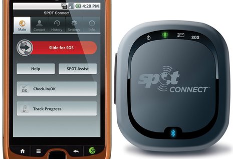
Yes indeed, that is an Android app serving as the extended front end of yet another iteration of the good old SPOT satellite messenger. It's called SPOT Connect, and it's a close relative of the Delorme joint product announced at this time last year. The SPOT hardware is again an independent, waterproof communicator that can send out a distress message by itself, but now its third internal wireless component -- after GPS and Globalstar short burst messenging -- is Bluetooth. Which means that a SPOT app on most any sort of mobile device can be used to send canned "Help" or "Check-in" emails/texts, or to turn on tracking, or -- and this was the big new feature on the Delorme PN60W -- write a custom 41 character message. Another Connect difference is that the actual shipping date will apparently come much sooner after the announcement...

 Gizmo is still ashore, but she shed her shrink-wrap this week and today I had a few enjoyable hours aboard tidying up and fooling with some new accessories. One is the handy mount holding the iPad up next to the Datalux police car computer (which apparently survived the winter aboard fine), but first let's talk about the free and very clever BoatUS smartphone app showing on the pad. Some of the features alluded to in that link aren't enabled yet, but its primary function -- making an automated call for a tow -- worked very well in my test...