Accessory GPS for iPads plus: Dual XGPS150 vs Bad Elf

... written for Panbo by Ben Ellison and posted on Mar 19, 2011
Bad_Elf___Dual_XGPS150_cPanbo.JPG

Over the last few weeks I've enjoyed testing two of the very few Apple-certified devices that can supply GPS to a WiFi-only iPad, as well as the iPod Touch.  They are the Bad Elf, which is available at Amazon for $99, and the Dual XGPS 150, similarly available at Amazon for $100.  The news is all good; both worked fine with every charting and mapping app I tried, which were many (a few here), and I think both validate the premise discussed when the Elf was first announced, that it's unnecessary to buy a 3G iPad just to get the GPS.  I must say, though, that the Bad Elf might have better prospects if the Dual hadn't come along so soon...

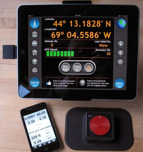
Please disregard the differences in position, altitude, and accuracy seen on the screens above. In actual testing, as opposed to a quick photo shoot, the Elf and Dual were usually in close agreement about all those values (and I swapped them between iPad and Touch multiple times). But the screens -- MotionX GPS HD on the iPad, and Memory Map on the Touch -- do indicate that both devices can supply ancillary GPS values like signal strength and accuracy if the software will display it. The same is true for COG, SOG, and even individual satellite positions and receive strengths, though I've yet to see an iThing program that can display the latter (and so I only know for sure that Dual supplies it, as it can also work with PC apps).  {Correction: Dual recently released a free iThing app that shows GPS satellite status, and Bad Elf is planning to add the feature to its app, as noted in a company comment below.}
   The refresh rate of a GPS is another important factor and while I can't find specs for either the Elf or the Dual, I can tell you that both can keep up pretty well with my truck at around-town speeds (too early for on water testing around here).  The Bad Elf system does include a utility app that easily updates it with firmware and/or the A-GPS info which purportedly helps it to get a fix quicker. In fact, I was amazed to see it acquire a location when I was 50 feet inside a mid-town Manhattan street level garage, but I didn't have the Dual then and up here can see little difference between their start-up times.  Both are decent, and both units seem to hold their fixes inside buildings and vehicles about as well as what I've seen from fairly current handhelds and high-end phones (like my Droid Incredible).
   But of course you can give a Bluetooth GPS a nice sky view somewhere on your helm or dash, especially well with the Dual as it includes that nice soft rubber mount. And the Dual worked fine for me when twenty feet away with a wall in between and a lot of home office type interference possibly in the air. You do have to keep the Dual charged up, but it does seem to provide the promised eight plus hours of duty, it does go into sleep mode when no app is active, and you only need a very standard Mini-B USB cable. You can use the Dual while it's charging but it will not serve USB GPS to a PC without Bluetooth (or log tracks on its own, like the solar-powered i-Blue I tested in 2007 and still have).
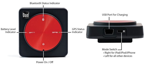
   I've never been able to use the i-Blue with my Touch or iPad and apparently never will because now that Apple finally supports Bluetooth GPS it apparently does so in its own damn way.  Which is why the Dual XGPS150 has that little switch you can see in the diagram below.  But the switch works and I didn't have any trouble pairing the Dual with a netbook running Coastal Explorer Express or Polar View. And it was only on the netbook that I could see all the GPS info the Dual has to share and, maybe more important, only there did I get serious alarming if I turned the Dual off. I digress, but all of you using iThing charting apps ought to check into just what notification you get when the fix is lost or the GPS fails completely.
   With the Bad Elf, you can not only avoid charging and Bluetooth-pairing hassels, but it comes with the newer Micro-B style USB cable which can be used to charge/synch instead of the proprietary Apple cable. In my case that means one cable can handle phone, iPad, and touch (and I've learned the hard way that having exta charging cables to leave on the boat is a good thing).  However, it is a little awkward to have the Elf sticking out of your iThing, and I suppose a wrong move could damage the port. On the other hand, the Elf is fairly trivial when peeking out of an M-Edge Leisure Jacket or sucked into a Dry Case (iPad case reviews here) or when clipped into that Pad Grip I just got (more details later but it does hold, tilt, and turn an iPad very nicely).
  At any rate, my personal first choice is the Dual XGPS, because I like the wireless trade-offs, but the Bad Elf ain't bad.  And easiest of all is just to get a 3G iPad, and I must note that they're making the data plans so flexible that folks who think they'll never use one just might.  By the way, the third iThing GPS accessory I know of is the GNS 5870 MFI GPS BT, which comes from Germany but is also available at Amazon for about $100.  And finally there's the interesting but tentative news that those with iPhone mobile hotspot capabilities can stream GPS along with Internet to WiFi-only iPads.

Dual_XGPS150_controls.JPG

Comments

The sample Dual XGPS is headed home, but I'll get to test the Bad Elf long term, and -- hot diggity -- that likely includes in boats on the Mediterranean next week!

Posted by: Ben E at March 19, 2011 10:25 AM | Reply

With the new ios, allowing tethering on the iPhone, people have found that when used with an iPad, the GPS data is also sent to the iPad. For me, this will be an even simpler solution, since the iPhone is always in my pocket.

Posted by: Brian Smith at March 19, 2011 10:27 AM | Reply

Any thoughts on devices for getting AIS into an iPad and/or Xoom?

Posted by: Kurt Schwehr at March 19, 2011 11:07 AM | Reply

Ben, Did either of these have the ability to display individual channel/satellite information? Thx

Posted by: Christopher at March 19, 2011 1:45 PM | Reply

Ben - Brian's right. iOS 4.3 has an interesting feature when it's paired with an iPhone - it appears to pass real GPS data from the iPhone to the iPad. I haven't seen it myself but it appears like enough people have tried it and found that it does work.

It's just another option. If you're in the iPad world, there's a good chance you have an iPhone too.

Wired and OceanLines are two of the places that wrote about it yesterday.

Personally, I still believe in the cellular version for iPad devices to get the GPS built in. It gives you the option of turning on the cellular data and costs about the same extra as getting a GPS dongle/add-on that needs to be powered, remembered, and managed.

Posted by: Jeffrey Siegel at March 19, 2011 2:08 PM | Reply

If you want an Ipad (I don't), first generation models are being unloaded right now by AT&T at very good prices. You can get the 64GB 3G model for $529 with no service commitment. That is three hundred bucks less than the early adopters paid.

Steve

Posted by: Steve at March 19, 2011 2:34 PM | Reply

I guess I wrote too much! There's a link to the iOS 4.3, iPhone, iPad thing at the end; note that refresh rate seems slow (though it shouldn't have to be via WiFi). And, by the way, there are some Android apps that can supposedly put a phone's GPS info out on Bluetooth.

Jeff, one good thing about an external GPS is that you can turn it off (or put a pot over it) and see how your nav app acts. I was surprised how many just freeze on the last position and numbers without a significant warning that your GPS has stopped.

I also wrote about individual satellites positions & strengths. The Dual definitely outputs the data, but I could only see it on the netbook. The Bad Elf may also, but I've yet to see an iThing app that can show a GPS satellite location/strength diagram. An Apple oddity?

Kurt, Try searching here and elsewhere for Digital Yacht iAIS and Brookhouse iMux, as well as Chetco and Maretron NMEA 2000 to WiFi bridges. iNavX is so far the only charting app that will see AIS over a boat's WiFi, I think, but I expect others and more hardware solutions.

Posted by: Ben E at March 19, 2011 2:37 PM | Reply

That is a heck of a deal. I use my plain vanilla WiFi only 16g iPad1 a lot for reading at home, and know it will be terrific for that, email, and more when I travel next week, and eventually on the boat. The mapping/charting apps are neat, too, especially for planning. But I worry that folks are ignoring the many shortcomings of those apps because they're so inexpensive and cool looking.

Posted by: Ben E in reply to Steve at March 19, 2011 2:46 PM | Reply

Ben, I took "if the software will display it" to indicate iffiness. Sorry. Perhaps I mis-read. We are hunting down a jammer in our area that only seems to be hitting three channels (and likely unintentionally).

We've been looking for a piece of software we can script to log the channel performance without getting into mucho bucks. I'll have one of our Apple-istas look into these. Thx

Posted by: Christopher at March 19, 2011 2:52 PM | Reply

The incremental cost of iPad 2 3g over wifi is a good value for me for the convenience of a terrific internal gps and the flexibility of perhaps wanting Verizon service on short notice without a contract [like in Camden]. My iPhone is ATT and in order to tether [now called 'personal hotspot' - kinda funky] I would have to give up my unlimited data service - forever. Any change in ATT iPhone data service away from the original unlimited plan requires the same permanent give up - so beware.
Brian

Posted by: bstrong at March 19, 2011 3:38 PM | Reply

The iAIS from Digital Yacht (http://www.digitalyacht.co.uk/product_info.php?products_id=11657) should do the trick. I have one on (express) order that I expect to see next week. I'll let you know.
-Dale

Posted by: Dale in reply to Kurt Schwehr at March 19, 2011 6:00 PM | Reply

Hi Chris,

Brett here from Bad Elf. Our accessory does support advanced APIs for getting the raw GPS data, including satellites in view, HDOP/VDOP, etc. The next version of our utility app will diplay these values, and we have a dozen or so app partners adopting our APIs right now as well. These will likely be appearing over the next 4-6 weeks.

http://bad-elf.com/support/bad-elf-gps-apis/


Kurt -

We do have some new products in the works with some marine-specific features. We've had lots of request for AIS and NMEA integration at a reasonable price point. If anyone has other itches we could scratch, let us know!

-Brett

Posted by: BrettAtBadElf in reply to Christopher at March 20, 2011 1:46 PM | Reply

Brett thanks for the info. I would certainly like iNavX to support the extended API you have provided. I direct many iPod and iPad users to BadElf. iNavX currently supports the standard Apple iOS "Location Services" which does provide for Horizontal and Vertical Position Accuracy. iNavX also supports NMEA data extensively including Satellites in View..

http://www.gpsnavx.com/iNavX/help/instruments.htm

iNavX can also repeat NMEA data to an autopilot and/or DSC VHF radio.

Posted by: GPSNavX at March 20, 2011 3:19 PM | Reply

Thanks, Brett. That's good news about the APIs and the advancements planned for your Bad Elf app. I was also interested to read on your site that some pilots feel the Elf is more reliable than the internal iPad GPS.

Plus I hadn't realized that Bad Elf can do WAAS corrections, and I don't think the Dual has that feature. But when I looked around Dual, I did discover that they recently put up a nice iPad/Touch app that let's a XGPS150 user see a satellite strength map and more:

http://itunes.apple.com/us/app/bluetooth-gps-status-tool/id422661436?mt=8

It's hard to keep up!

Posted by: Ben E at March 20, 2011 3:24 PM | Reply

In fact, the 1.0 Dual app shown on iTunes doesn't look as advanced as this screen shot from their site, which may be in an update that hasn't made it thru Apple yet:

http://xgps150.dualav.com/images/HowItWorks/detailed_screen.png

Posted by: Ben E in reply to Ben E at March 20, 2011 3:42 PM | Reply

Brett thank's much, I'll tell the Apple users on our dock. Chris

Posted by: Christopher at March 21, 2011 8:05 AM | Reply

I've used both Bad Elf and the Dual XGPS150 with a WiFi-only IPad. Both work very well but I prefer the wireless approach of the Dual to the Elf dongle sticking out of the IPad. I've been able to use both successfully with Navionics, Charts&Tides, TidesPlan10, BuoyData and Navigon (for land-based navigation). I've seen fixes accurate to one meter with the Dual. After reading your comment about GPS over WiFi, I checked and I am indeed getting limited GPS data over my Verizon MiFi. Incidentally, if anyone has the need, I have figured out how to make my boat's WiFi network join my MiFi wirelessly to get internet access as soon as I get on the boat. Also, when the boat is tethered to WiFi I use a free dynamic routing service to make it possible to telnet in to the boats computers and to watch status on the boat's status website. All of this runs on a credit card sized ARM board running Linux and taking negligible 12v power.

Posted by: Bill Southworth at March 21, 2011 10:00 AM | Reply

The wireless data being sent over the MiFi by Verizon seems to come and go and not be particularly accurate. OK for rough navigation but not good enough for directions, in my opinion.

Posted by: Bill Southworth at March 21, 2011 10:03 AM | Reply

The new GPS support over iOS 4.3 talked about really shines when you're using an iPhone as the tethering device. Since the iPhone has a real GPS, it send much higher-accuracy data over to the connected iPad. The results should be much better than what you're seeing with the MiFi.

Posted by: Jeffrey Siegel at March 21, 2011 10:37 AM | Reply

hi
has anyone noticed problems with iPad2 due to it having the MAGNETS built in? I have only a small 27 foot sailboat and everything is close to the compass mount.

Posted by: rogerhudson at March 21, 2011 6:35 PM | Reply

I have used the "GNS 5870 MFI GPS BT Receiver" on my iPad2 and iPod Touch. It seem to track very close to my DGPS system. It was easy to mate with the iDevices. It would be nice if there was better access to connect with any bluetooth device.

Posted by: Tom Rutter at March 22, 2011 7:00 AM | Reply

From TUAW -
"...It seems that iPad 2 users will no longer have to fear false (water damage) positives because Apple has apparently removed the LCIs from a redesigned headphone jack as well as from the docking connector. 9 to 5 Mac even posted an updated procedure in the Genius DB advising checking for water damage by looking for corrosion in the SIM card tray on the iPad 2."

http://www.tuaw.com/2011/03/28/ipad-2-loses-water-damage-indicator-at-headphone-jack/

Posted by: John K at March 29, 2011 12:35 PM | Reply

Adding wireless GPS units to my sailing/racing website has been on my (lengthy) To Do list, but the battery issue has made it a lower priority than wired (and PC card) devices. Specs of "up to 8.5 hours of continuous use" and "4 hour" recharge for the Dual won't cut it for many marine applications, and when the battery runs out, you can be SOL. If you're going to keep it charging on USB, then why go through the hassle of wireless instead of just using a USB-connected unit? When I'm stuck with battery power, I prefer units with swappable batteries. To be clear, I'm not crapping on the general idea, which can be useful in some cases (e.g., when wired is not possible and battery life is not a big issue), just expressing my own general take.

Posted by: John Navas at April 25, 2011 12:13 PM | Reply

If you have an iPhone, you can use this app to turn your iPhone into a GPS receiver for any app that supports NMEA over TCP/IP (i.e. MacENC, iNavX, Coastal Explorer, PolarCOM, etc.) ..

http://itunes.apple.com/us/app/gps-2-ip/id408625926?mt=8

It will even run in the background.

Posted by: GPSNavX at April 25, 2011 1:07 PM | Reply

John, A USB GPS is not an option for iPads. They don't have a USB port, and even you use the USB dongle I don't think there's a GPS that will work with it, let alone take power off it.

Posted by: Ben E in reply to John Navas at April 25, 2011 1:19 PM | Reply

"John, A USB GPS is not an option for iPads. They don't have a USB port, and even you use the USB dongle I don't think there's a GPS that will work with it, let alone take power off it."

I know that. I consider it a fatal flaw. I would get the 3G model with GPS, or an Android tablet with GPS and/or USB; e.g., Archos 5 Internet Tablet with GPS for under $200.

Posted by: John Navas at April 25, 2011 1:50 PM | Reply

I tried this as soon as I read it and it works great. Just configure the IP addresses of the two units to see each other and voila, the Iphone is your GPS receiver. Does anyone have an opinion on the quality of the GPS signal and accuracy of the Iphone? Does it have a real GPS signal or will I lose it as soon as I lose my 3G signal?

Also anyone have a opinion on a good waterproof case for the Ipad, I have a cuddy and it will be open to the elements somewhat.

Posted by: posedion in reply to GPSNavX at April 27, 2011 7:22 AM | Reply

"Does anyone have an opinion on the quality of the GPS signal and accuracy of the Iphone? Does it have a real GPS signal or will I lose it as soon as I lose my 3G signal?"

"Assisted GPS" in the case of iPhone just means that network data can be used to greatly shorten start time to first fix and to improve position accuracy in difficult signal conditions (e.g., indoors). The iPhone GPS receiver can work without a network connection, but accuracy is poor as compared to dedicated GPS units in my tests (position errors of as much as several hundred feet notwithstanding much smaller estimated errors). I would not use it for serious navigation.

Posted by: John Navas at April 27, 2011 9:49 AM | Reply

Re AIS for Ipad

Brookhouse have their Imux available to stream GPS, AIS, instrument data etc etc via Wifi to any device capable of reception.

http://brookhouseonline.com/imux.htm

It is also possible to automatically plot the position of a received DSC emergency call.

http://brookhouseonline.com/dsc_conversion.htm

Posted by: John at April 28, 2011 4:58 AM | Reply

Posted by: GPSNavX at April 28, 2011 7:44 PM | Reply

Chris,
I appreciate all of your comments for your setup for your iPad and your boat. I too have just picked up an iPad2, dual gps and navionics hd software. I'm having some very slow gps refresh issues in the app, have you experienced this? If so, can you let me know how your corrected the issue? Thank you much

Posted by: Anonymous in reply to Christopher at June 26, 2011 10:02 PM | Reply

Chris
I'm have the same setup and the same very slow GPS refresh issues with the Navionics HD. Have you found a solution yet? I have a trouble ticket with Dual but having no luck with them.

Posted by: Steven at July 13, 2011 2:25 PM | Reply

FYI, I was using Dual GPS with an iPad2 running iNAVx. The Dual worked for a few week. But, having left it out in the sun it stopped working. I guess it is not too robust. Will try the GPS BT GNS next.

Posted by: Paulius in reply to Ben E at August 8, 2011 7:55 PM | Reply

Garmin just arrived in this space, big time. The Garmin
GLO is a Bluetooth GPS that also uses the GLONASS system and also refreshes at 10 times a second:

https://buy.garmin.com/shop/shop.do?pID=109827

Posted by: Ben E at July 15, 2012 10:41 AM | Reply

Bad Elf has a new Pro model iPad, Touch, etc. GPS that looks very interesting. Bluetooth, data logging, apps...

http://bad-elf.com/products/be-gps-2200/

Posted by: Ben E at September 26, 2012 6:21 PM | Reply

Leave a comment