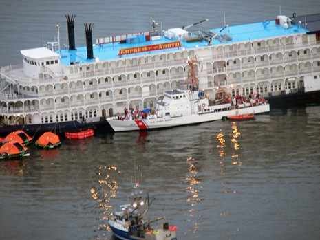
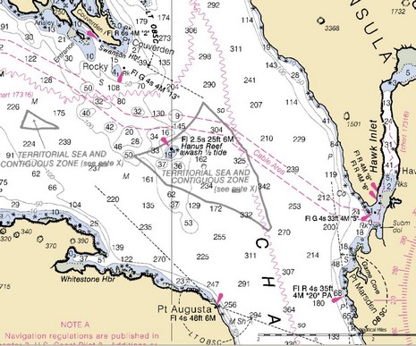
That’s the Coast Guard cutter Liberty off loading some 130 (of 250) passengers from Empress of the North after she supposedly hit Hanus Rock in Alaska’s Icy Strait at 2am this morning. I’m certainly not qualified to blame others for nav mistakes, but apparently this vessel has quite a history of groundings, and Hanus Rock looks like it’s well marked and has lots of room around it. (If I have the right spot; I haven’t seen a map of the accident yet, but did find this Hanus Reef at the south end of Icy Strait.) It will be interesting to see the accident report.
PS 5/15: Soundings just put up a Web “Channel” covering multiple USCG rescue operations off North Carolina last week.
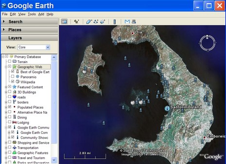
This weekend a Panbo reader emailed me thusly: “How about an in-depth look at the electronics and friggin' AIS on that cruise ship that grounded then sank???” Well, I wish I could find the details of what electronic aids were available on that now sunken bridge, but I have little doubt about the accident’s cause. Incompetence trumps electronics every time! While I generally sympathize with a skipper who screws up—one result of my own numerous navigation errors—there are indications that this was an accident about to happen. One is that the Captain blamed strong currents for the grounding. As if set and drift shouldn’t have been toward the very top of his worry list, a critical factor to be on aware of, using electronics or older means. Then read down the same article to see how Sea Diamond’s operating company already had two serious accidents in the last year. Incompetence often flows from the top. At any rate, the news reports about this tragic sinking will surely get more detailed. For instance, I can’t yet find a map of just where it happened, so I looked up Santorini, Greece, in Google Earth. While there are numerous interesting POI entries about the island, no user has yet geo-located the wreck. But I wouldn’t be surprised to see that soon, GE being the global community map it’s become (more on that later).
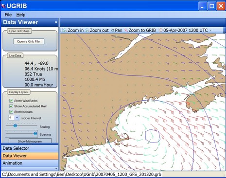
In Maine speak, that low pressure system which blasted through here last night was a “corker”, leaving at least 10” of snow which has a gluey consistency unfriendly to snow blowers and plows. Panbo world headquarters is still digging out! Now, of possibly greater interest, that screen above is from a new and quite nicely done weather program called UGRIB. It lets you download and display forecasts for any section of earth as generated by NOAA’s “global numerical weather prediction model.” And it’s all for free, thanks to the folks at GRIB.US. You only get wind, pressure, and precipitation—and, of course, you can find far richer weather data on the Web—but one beauty of GRIB files is their compactness if your data pipe is limited…like, say, a sat phone out in the ocean. GRIB numerical data can also be animated, as UGRIB does, and used by routing programs. Meanwhile, back here in Maine, a 40’ scallop boat sank Tuesday night as it tried to return home ahead of this storm. The crew is fine, apparently because they were well equipped with EPIRBs, survival suits, etc. The Luke & Jodi even had some sort of transponder such that the owner could track it from home, though that let to some confusion. At any rate, the crew did everything right according to the Coast Guard, except perhaps deciding to supply the liferaft with a case of beer and bottle of vodka “to keep them occupied while they waited to be rescued.” That led to problems (and more detail here).
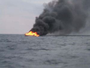
That’s a 35’ Viking, ironically named “Lit Up”, as it became “the world's largest flare gun” off Mayport, Florida, on Feb. 10. All six crew survived just fine, thanks to good planning and gear. Doug Ritter, of the always valuable Equipped.org site, first made me aware of this accident, and the picture comes from a thorough article at Jacksonville.com.
There’s no question that some boaters out there, even pros, are misusing electronics, which is why we have terms like “radar assisted collisions” and more recently “computer assisted groundings” spoken only half in jest. Now the January issue of Seaworthy magazine identifies a whole category of marine accidents they’re calling Electronically Aided Collisions or EACs. Seaworthy, aka “The BoatU.S. Marine Insurance and Damage Avoidance Report” is a terrific publication, I think. Using the vast boots-on-the-ground research conducted by BoatU.S. adjusters, the editors present the real hazards of our past time in a calm, useful manner. They have a sense of humor too, for instance titling a sidebar on a mast accident “It’s not the falling that hurts, it’s the stopping,” and including this quote in the EAC feature:
“My wife used to refer to the boat’s nav system as my $10,000 video game. After I bent both props and rudders on some rocks while I was showing her how the system worked, she started calling it my $20,000 video game.”
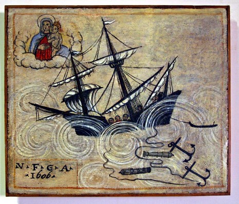
I think of this painting—one of an ancient series hanging in the Venice, Italy, Maritime Museum (and bigger here)—as a how-to for sailors caught out in a storm: Put out all your anchors, jettison heavy objects (like cannons), pray to your personal savior, and hope for the best! Here in Maine we’re trying not to get upset about the freakish fact that the ground hasn’t frozen yet (and I’m thankful that we live some 180’ above sea level). But I trust that whatever happens is all in God’s plan, and I wish you all a very fine Christmas, or Chrismakka as we call it in our home, or however you honor this grand turning of the seasons.
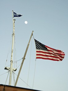
I spent the winter of 1972 living in New Orleans and working on oil field supply boats, acquiring a huge fondness for the former (not so much the latter). But I haven’t been back until this week, and naturally was very curious about how well this wonderful city is recovering from Hurricane Katrina. Well, of course it depends a lot on who you talk to, and where you aim your camera. The shot above, bigger here, shows some wrecks still lingering in the same Lake Ponchartrain marina we saw in before-and-after satellite shots back in 2005. Even right there on the spot it’s hard to imagine the ferocious weather conditions that could break off one boat’s keel on a dock, impale another with a piling. But you can see that the nifty boathouse/apartments in the background are getting rebuilt, and a turn in either direction would show many new or fully refurbished boats and docks. The “we will survive” spirit particularly showed at the Southern Yacht Club—going full steam in temporary buildings under a resurrected flag mast, brand new club house and facilities in the works.
And the Big Easy is still very much a paradise of spirited music and food. Even an oyster po’boy from the Convention Center commissary was a total treat. The French Quarter’s Bourbon Street may have gotten more touristy and debauched in the years I’ve been away, but there’s a certain evolved brilliance there. It’s closed to traffic now, and dozens of clubs compete for your attention with various entertainments, drink deals, etc. However, there are no cover charges or waiting lines; you’re free to wander in and out of most any of them, even nursing a large take-out beer, like it’s all one huge club. Laissez les bon temps roulez, and go enjoy New Orleans when you can.
While doing 18 knots 1,000 miles south of Cape Town yesterday, Alex Thomson’s Hugo Boss experienced canting keel failure, nearly capsizing. At the crack of dawn this morning another racer, Mike Golding, pulled off a remarkable single-handed rescue, then hours later, lost his own mast! Despite all this, both skippers seem to be in regular sattellite phone contact. The story is unfolding here.
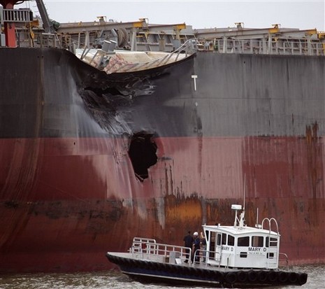
A Panbo reader (thanks, Mark!) alerted me to yesterday’s collision on the Mississippi, in which the 712’ Greek freighter Zagora, coming down river with a load of soy beans, apparently T-boned the anchored 737’ Panamanian freighter Torm Anholt. Mark wrote, “It is amazing that yet again two ships of this size are able to hit each other. And to think one of them was anchored. How is it that small vessels are not plowed under more frequently? Looking forward to class B AIS transponders.” I’m looking forward to Class B too, but we should all be very careful not to over estimate its value. Interestingly, another Panbo reader (thanks, Kurt!) linked me to a page of presentations given at the recent AIS/06 conference. There’s a lot of interesting material there, which I’ve only skipped through, but of particular note is the first day presentation by Dr. Andy Norris. One of his conclusions is that “Class B users must not assume that their AIS signal will be visible on any ship.” More on Dr. Norris’s work to come. And some day the National Transportation Safety Board will issue a report on the Zagora/Torm Anholt collision. NTSB reports don’t seem quite as detailed as the MAIB work I’ve referenced before, but it will be interesting to see what happened on the big River yesterday afternoon.
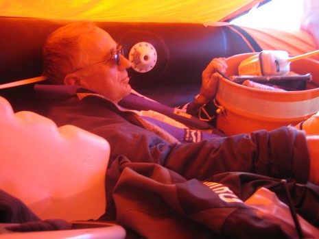
Whereas we seem to have reached consensus that Iridium does not suffice as an EPIRB, it seems appropriate to post this intimate photo of a man apparently in love with his EPIRB. No wonder. At 7:30am on 7/25/06, Captain Nick Barran’s 40’ racing sloop was holed by a whale 415 miles north of Hawaii. He and his crew had about an hour to gather their stuff, inflate their life raft, and watch Mureadrittas XL vanish into the deep Pacific. They took pictures, too, and most sites published dramatic images of decks awash and a hand about to slice the raft’s tether. Me, I like the shot of Barran, probably very shook, laying back in the raft next to his faithful ACR RapidFix. The thing, and the whole COSPAS-SARSAT system, worked like a charm and this well equipped crew was aboard the container vessel Maersk Darwin before the sun set. ACR lays out the story here, and also has a pretty compelling advertising campaign here, but no PR person was there aboard the container ship prompting Barran to pose holding his EPIRB. I wonder when he let it out of his reach? By the way, there was also a satellite phone aboard Mureadrittas XL.


 break off one boat’s keel on a dock, impale another with a piling. But you can see that the nifty boathouse/apartments in the background are getting rebuilt, and a turn in either direction would show many new or fully refurbished boats and docks. The “we will survive” spirit particularly showed at the