Empress of the North, & Hanus Rock

... written for Panbo by Ben Ellison and posted on May 14, 2007

Empress-of-the-North-3

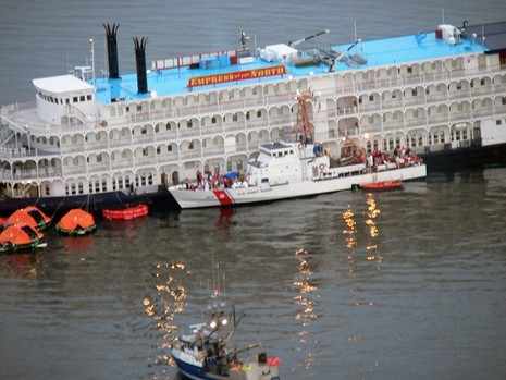
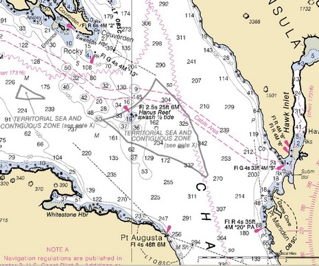
That’s the Coast Guard cutter Liberty off loading some 130 (of 250) passengers from Empress of the North after she supposedly hit Hanus Rock in Alaska’s Icy Strait at 2am this morning. I’m certainly not qualified to blame others for nav mistakes, but apparently this vessel has quite a history of groundings, and Hanus Rock looks like it’s well marked and has lots of room around it. (If I have the right spot; I haven’t seen a map of the accident yet, but did find this Hanus Reef at the south end of Icy Strait.) It will be interesting to see the accident report.

PS 5/15: Soundings just put up a Web “Channel”  covering multiple USCG rescue operations off North Carolina last week.

Hanus Reef

Comments

Ben, I believe you have the right reef. I am from Alaska, but now live in washington. Moving map displays really do prevent this type of accident. You can steer a route on the GPS moving map display, watch the radar, monitor your AIS, glance at the depth sounder, and drink a cup of coffee. Modern marine navigation is so wonderful. Much much better than the old days, when you didn't know exactly where you were, and at best knew where you had been. We didn't have a clue of what other traffic was of concern, etc., etc. You did know the correct time because of your Casio watch.

Pat Harman

Posted by: Pat_Harman at May 14, 2007 8:59 PM | Reply

Let's hope a map was not being used..

http://nauticalcharts.noaa.gov/Staff/map-cht.htm

Posted by: GPSNavX at May 15, 2007 12:08 AM | Reply

Righto, NavX, but I was hoping that the media would "map" where Empress of the North made a "charting" error (or something happened). Isn't it odd that Google shows over 1,000 news articles about the grounding but not one seems to include a map, and some say 15 miles southwest of Juneau while others say 50 miles west?

Posted by: Ben at May 15, 2007 4:25 AM | Reply

I have been doing a lot of research on this story for my new site gCaptain.com and I think we have the reason figured out. You can read the story here:
http://gcaptain.com/maritime/blog/category/incidents/lifesaving-incidents/

Posted by: gCaptain.com at May 21, 2007 1:47 PM | Reply

In
http://www.adn.com/money/industries/tourism/story/8891574p-8791696c.html
it is reported that the Empress of the North struck Rocky Island during a course correction while navigating a 90 degree right turn in the Lynn Canal of southeast Alaska and then drifted aground onto Hanus Rock.

Posted by: Anonymous at June 21, 2007 9:54 AM | Reply

Always need a "plan B"

Interesting follow up on this story. It sounds like they had a number of safty issues.

"...On May 14, as the ship's 206 passengers were evacuating, crew members found that half of the 22 life rafts didn't deploy properly. The pumps that launch the life rafts had not been lubricated as directed by the Swedish manufacturer, CM Hammar AB, according to the NTSB. Crew members used their own knives to cut the lines attaching the rafts to the 360-foot ship, the safety board said.

In addition, the ship's two evacuation slides inflated upside down and appeared to have been repacked incorrectly during an inspection by a Coast Guard-certified vessel safety company in February, the board said... "

Full story: http://seattlepi.nwsource.com/local/322848_cruise07.html

Posted by: Mark Read at July 8, 2007 5:54 AM | Reply

Leave a comment