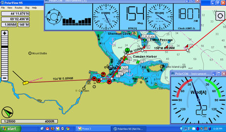
I took a peek at PolarView NS charting software about a year ago, but didn't write about it because I wasn't especially impressed (and there's a certain randomness to what I cover anyway). But times change and software develops, and I'm here to tell you that PolarView 1.5 (video introduction here) is pretty darn impressive. Given its app-like $40 price tag, it's a remarkably powerful program that runs on Windows, Mac OS X, and Linux operating systems. The screen above shows PV running on my little ASUS Eee PC 1000HE 10-Inch netbook
with live NMEA 0183 data coming from the lab's N2K network via a Maretron USB 100. PolarView is quite unusual in that it uses a sister program, called PolarCOM, to do all its data interfacing and instrument displays...
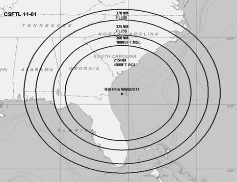
This seems odd. Yesterday the FAA issued a Flight Advisory -- PDF here -- warning that during a period of "GPS testing" starting today aircraft transiting the large area diagrammed above might find that "the GPS signal may be unreliable or unavailable." Huh? But never mind sites like Engadget which immediately assumed that "anyone planning on using GPS in the southeastern US for the next month or so will likely want to make sure they have a fallback option." If you read the Advisory carefully you'll see that whatever is being tested -- which sure seems like jamming to me -- will apparently be more effective at high altitudes than at the levels most of us travel...
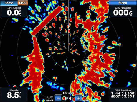
So that's the Garmin GMR 604 xHD open array radar I installed last May painting a crowded harbor on the screen of a GPSMap 7212 in late July. Gizmo was headed southwest at the time -- the GPS heading, or COG, is meaningless because she's tied up to a float -- and so you have to twist your brain a bit to see how well the radar is imaging the details of Jonesport's Sawyer Cove, and hence that the long straight target at the upper left is the famously uncharted steel and concrete breakwater there. And I think if you make the comparison you'll agree that the true color target display really helps to understand what the radar is doing. Those light blue and green returns at upper left, for instance, are almost certainly some sort of noise created the breakwater's heft and hardness. I could have turned the gain down to eliminate that noise, but then I might not have seen the light blue at lower left -- which is an emerging mud flat, I think -- and similarly difficult targets once I got underway. True color returns is indeed my favorite feature of the xHD/7212 combination...
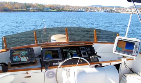
I was happy to do some late season cruising and electronics testing on Gizmo this year, and am also happy that she's snuggled high and dry under shrink wrap now that winter -- including at least a foot of the white stuff -- is really here. But something I'm really excited about in 2011 is my plan to take the boat south next fall. Oh, I don't intend to stop working; in fact, if the manufacturers continue to cooperate with what may be the industry's longest testing program, Gizmo's flying bridge will look fairly similar to what I put together this season. (Which, come to think of it, I haven't shown off until now; click above for a bigger image, and be assured that I have hundreds of screen shots yet to sort through and write about.) The thought of a long gunkholing, blogging, and boat-show-ing circuit to, say, Charleston and back is sure motivating me, though...
At first glance Standard Horizon's new CPN may look like a fairly standard multifunction display, but note the "turn page" screen graphic at lower right, the small (but purportedly powerful sounding) stereo speakers, and the "Multimedia Chart Plotter" designation. The 7- and 10-inch CPNs have touch screens not only to help manage charting, optional radar, and so forth but also to select audio and video entertainment stored on front or back connected USB sources, or streaming over WiFi. And, yes, there is a Web browser in there too!
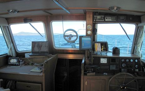
It's about to be Thanksgiving here in the states, and -- aside from the normal family stuff (which is huge) -- I surely am thankful for being the custodian of a wonderful boat, for living in a beautiful corner of the oceans, and for getting to fool with some great technology. Above is Gizmo's lower helm, the Fall 2010 edition, and while there's a lot here that I haven't written about yet, I'm going to focus today on that little Garmin GPSMAP 740 on the chart table...
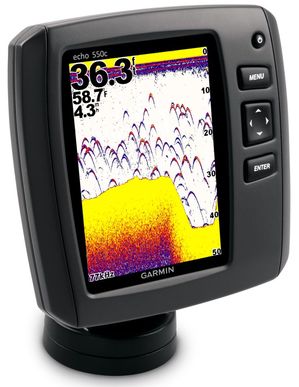
The press release characterizes the new (little 'e') echo series fishfinders -- six models in all, with the $450 550c above at the high end, and an $80 echo 100 at the low -- as "Garmin's return to the freshwater market." Which I read as "Hello, Lowrance and Humminbird!" and also as another sign of the company's tenacity. Dropping out of the hyper intense smart phone market may have been wise, but Garmin usually seems to meet competitive adversity with new models, improved features, better value, etc. They may have lost focus on the inland market for a bit, but they're back, and consider too the new xHD 4kW open array radars...
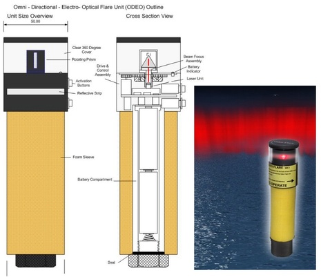
DAME Awards will be chosen at METS this coming week for multiple categories, but there are electronical things well beyond the main marine electronics category discussed on Thursday. Consider, for instance, how the ODEO Flare seen above attempts to replace pyrotechnics with four lasers and a revolving prism. It does cost almost 100 pounds, but purportedly stays lit for 10 hours on 2 AA batteries, and it won't burn you. Also in the Lifesaving and Safety Equipment category are SeeTrac's Jet-trak high-end PWC tracking system, McMurdo's SmartFind S5 AIS SART, and Weatherdock's easyRescue, which seems to be a personal-size AIS SART. And of course there's the Marine Related Software category...
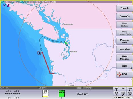
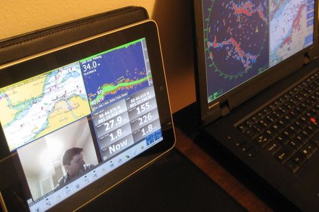
Real time fuel range -- as when it's calculated using actual fuel flow and tank levels -- is darn useful information; for instance, it should let you instantly see the effects of RPM or sea state changes not only on your MPG but also on your ability to get somewhere without a forced stop. Which is why it's neat that the Nobeltec 11 preview screen above shows the value as a number, as a circumference from your present position, and even as a distance along your active route. And there's an implication to this screen that I'm sure many of you will welcome (and may have already figured out)...
It's not just the new edition of Coastal Explorer that can play nicely with an iPad. In fact, it turns out that anyone running Nobeltec Admiral v6.5 or higher can get their iPad to show a variety of independent screens like the one above. (Right up through the latest 10.7 update, which apparently fixes numerous bugs, adds support for the latest Windows versions, and marks the welcome demise of Jeppesen's Raster Plus Pack gaff.) That's because Admiral has long supported the extended desktop capabilities of Windows, as well as touch screens. But Nobeltec Product Manager Bill Washburn, glimpsed in his own camera above, warns that screen refresh rate is marginal, at least at this point...