Gizmo Thanksgiving, & the Garmin 740 networked

... written for Panbo by Ben Ellison and posted on Nov 24, 2010
Gizmo_lower_helm2_fall_2010_cPanbo.JPG

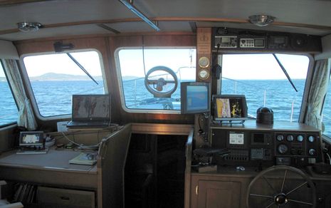
It's about to be Thanksgiving here in the states, and -- aside from the normal family stuff (which is huge) -- I surely am thankful for being the custodian of a wonderful boat, for living in a beautiful corner of the oceans, and for getting to fool with some great technology.  Above is Gizmo's lower helm, the Fall 2010 edition, and while there's a lot here that I haven't written about yet, I'm going to focus today on that little Garmin GPSMAP 740 on the chart table...

Several local boaters have checked out the loaner unit I lab tested in May, and I'll soon publish their comments on using it as a standalone plotter (they liked it a lot).  But I also think the 700 Series can make sense as part of a larger system.  No, it can not network via Ethernet with Garmin's major MFDs, radars, and so forth, which I confirmed.  When I connected it via Ethernet cable to the 5212 -- which is also high speed networked to the 7212 on the flying bridge and to the xHD radar -- the 740 delivered a polite but firm message about how it was experiencing an unauthorized connection and would shut itself down in 15 seconds!  Fair enough; removing fast networking abilities from the 700 series is apparently a significant way that Garmin was able to hold down its cost...

Garmin_740_instrument_display_cPanbo.JPG 
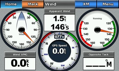
But as far as I can tell, Garmin didn't hold anything back when it comes to the 740's NMEA 2000 networking abilities. It can manage and decipher all the sensors that the big displays can (in this case ST-STng Converter output), and in fact the big ones can't yet emulate analog gauges as well as the Wind screen above does.  There are also dedicated instrument screens for Environment, Engines, and Fuel Management (with a decent amount of customization possible), which means a 700 Series can be used like an extra large GMI 10.  Except that it can also handle the complexities of Garmin's more proprietary N2K devices.  It can, for example, manage and display Garmin XM weather and audio just fine.  And while it can plot any device's output of N2K or NMEA 0183 AIS target data, it can also simplify direct VHF calls to those targets if there is a Garmin radio on the N2K network. I spoke with a trawler guy yesterday who is thinking of using one primarily as an AIS display because he likes to keep his bigger Garmin MFD more zoomed in for regular navigation.
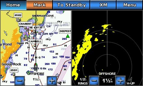
   It may seem extravagant to use a 7-inch touchscreen MFD primarily as an instrument display or for zoomed out target tracking, or just for scanning XM channels, but less so when you consider how far that $1,500 might go elsewhere.  And that you also get a first class back-up plotter with all U.S. and even Bahamas charts built in, and a back-up radar display.  The test unit may have balked at Ethernet networking, but it was quite happy to receive the Ethernet output of the GMR 604 xHD directly, and since the 3.0 software update, it can even do overlay, as seen below.  The 700 Series is maybe something worth being thankful about?

Garmin_740_radar_overlay_cPanbo.JPG

Comments

Ben, I taught the xHD radar had multi color , its seems the same as my standard Garmin radar.

PS: happy thanksgiving

Dave

Posted by: GBN at November 24, 2010 1:37 PM | Reply

This reinforces one of my very few beefs with the current Garmin product line, none of the smaller form factor chartplotters network with the larger MFD's to share charts and routes even if they have the network capability.

I would love to have one of the smaller units out at the helm of my sailboat where there is no room for a larger unit instead of ducking down below all of the time to look at the 4210.

I believe this is a marketing decision by Garmin and not a technical / component cost decision as you alluded to above.

If the unit has a Garmin Network connector and can use the radar and some of the other devices on the network, then the only reason it can not link with the larger MFD is the software was designed (crippled) not to.

Posted by: Evan at November 24, 2010 2:15 PM | Reply

Dave, the true color returns possible with xHD only show on the 6- and 7000 Series MFDs. It is indeed silly to using a 4' open array high def radar with a screen as small as the 740, especially in split screen mode, but maybe not if a more appropriate bigger screen breaks and the 740 is all you have for a while.

Evan, you could get a 5208, which isn't all that much bigger than a 740. But it is almost twice the price, which may well be reason that the 740 is somewhat limited. My point is that it isn't drastically limited, and a lot of MFD for the money.

Posted by: Ben E at November 24, 2010 3:17 PM | Reply

I love the size of these screens. At 35 years old, I can easily see the screen to use this type of unit as my primary plotter. The 740 is very compelling, but they're still a little bit pricey and they are definitely too tall for my helm. I need the height to be less then 4.75". At 5.6" high, they simply will not fit. Right now I have two GPSMAP 3005c's side by side with ethernet connection between them. My height is definitely max'ed out with the two 3005c's and the 740 is almost a full inch taller.

My 3005c's are a few years old, but they do ethernet sharing of charts/ waypoints / routes, XM Radio & Weather, Radar, MARPA and AIS. They don't do all the NMEA 2000 stuff, or the click to call on AIS Targets, but my VHF can click to call AIS targets, so I don't need that function on the plotter. I am not sold on having a touch screen for the boat. That seems like it would be difficult in a smaller boat at a higher speed in the weather. I have enough trouble trying to get my finger on the correct button while bouncing wave top to wave top. With my rubber buttons I can steady my hand on the correct button before giving it a good push. I am guessing that lightly brushing the touch screen is going to register as a press? That's going to be a problem in the weather.

My 3005c's were $800 each when purchased new. To duplicate that setup today with a pair of 740's would cost me $3k. To be fair, I have to add the cost of the black box sounder and the charts into the total for my 3005c's. Still not nearly as much as the 740's. Any my $100 chart card of Lake Erie includes Canadian Charts, which I also need to add to the 740. IMHO, the 740's don't do enough extra stuff to warrant the cost premium over the old 3005c's.

To the entire industry, if you are listening: bigger screens, smaller bezels! Offer rubber buttons as an option. I think the perfect helm setup would be two displays side by side, one with rubber buttons and one with touch screen. Or possibly produce a touch screen unit like the 740, and also a unit that is the size of the GMI 10, but has no screen. It would only have rubber buttons and is the button set that you would normally see on a non touch screen unit. Users may find themselves mounting the "button box" closer to the helm chair, so they can work the plotter with buttons they can feel while underway without getting out of the helm chair. Then you have the best of both worlds?

Posted by: Bob Mueller at November 24, 2010 9:04 PM | Reply

I wrote about this about a month ago. The only problem I have is my Class B AIS transponder is a NAIS300L (non Garmin) and I self alarm on the 740. However I just disable the alarm on power up of the 740. Other than that ir works well with all my NMEA2000 sensors and the Garmin6212 and 4210. It's got a great display for it's size.
Bill Lentz

Posted by: Bill Lentz at November 24, 2010 9:25 PM | Reply

Ben - Actually, what I wanted to install was a 3205, which can be picked up for about $500 now, and is a nice small size for my helm, but Garmin told me that even though it plugs into the network, it can not share route information, never mind charts with my 4210 and that there were no small form factor units that could. The 5208 is way to big for the space I have, I am looking for something closer to the size of a GMI 10, than a 5xxx.
It is Garmin's loss in this case, as I will do without, or buy a cheaper NMea repeater, rather than buy a larger unit.

Posted by: Ben at November 24, 2010 9:27 PM | Reply

One heads up on the Garmin 700 series when used with a GMR 18 or 24 HD radar.

There is a recall for the early HD radars because they will not work with the 700 series. Garmin will ship a refurbished radar to replace the one you have if you buy a 700 series plotter. I found this out at the Annapolis Boat show after enquiring about the 740 for the cockpit. For sailboats this means you may have to be prepared to pull the mast, rewire and re-step which can be costly. It is possible to do the radar scanner swap from the end of a halyard if you are still young and understand the risk. Another words, On long Island, NY add another thousand to the cost of the Garmin 740 if you have an early GMR-24HD.

Posted by: Richard C at November 25, 2010 7:59 AM | Reply

Evan,
I can't agree more. The inability to network Garmin's own products is a serious oversight on their part. I too would add a 740 to my cockpit and network with my existing 4212 below at the navigation station and our GMR-24HD radar. Not only does Garmin restrict customer to use only Garmin charts, radar, etc they now restrict us from using their own family of products.

Garmin already has developed proprietary networking so there should be no cost involved here. Punching out a few more holes in the circuit board and throwing in a dollar fifty worth of components is something I would pay extra for as it opens a door to much wider benefits to the end user as well as enormous sales possibilities for Garmin.

The Garmin decision makers need to come sailing with me.

Posted by: Richard C in reply to Evan at November 25, 2010 8:13 AM | Reply

Here's the Garmin service document with the serial numbers of 18 HD and 24 HD radomes that won't work right with 700 Series MFDs. Shouldn't hard to swap out, if your isn't up a sailboat mast ;-)

http://www8.garmin.com/marine/notices/SA1030A.pdf

Posted by: Ben E at November 25, 2010 9:51 AM | Reply

this Garmin model seems expensive for what what it does... i choose to add the Lowrance HDS-7m, fully NMEA 2000 compatable with everyhing we have (Simrad) and other brands, also uses the same chart/s, shows engine data and has its own built in internal GPS antenna so it really funtions as stand alone back up GPS and secondary screen for everything else AIS, Radar, Engine Data, Depth/fish Finder, because it accepts not only the NMEA 2000 and 183 but Ethernet as well... all for under $900.... this was a good value for the use intended, IMHO.
Jeffrey

Posted by: Jeffrey at November 25, 2010 9:51 AM | Reply

I agree that the HDS series offer good value, and plaudits to Lowrance for making what I think are the smallest, least expensive fully networkable MFDs. But to make the comparison fair, note that the MSRP on the 7m is $999, its screen is actually 6.4", and the 740 also has a internal GPS. The big thing for a lot of people, though, is the 740's touch screen interface and relatively small footprint.

Posted by: Ben E at November 25, 2010 10:57 AM | Reply

Is anyone thinking or running 2 separate NMEA2000 networks in their vessels? I'm in the middle of a re-power and replacing Mercruiser System View 5000 displays with 2 Maretron 250 displays, the EMS100 A to NMEA200 converters and the Yanmar specific sensors and wiring harness. I already have spare NMEA200 GPS available. I could easily cross connect the networks by adding a drop and removing a termination. There would be times I might want to view the engine data from my Garmin NMEA2000 displays but I'm thinking for reliability keeping them separate but designed to quickly add it to my navigation NMEA2000 existing network.
I'm doing this to keep my all glass dash with no analog gauges.
I have noticed the more NMEA2000 devices I have added to my existing Garmin plotters the slower the system seems to operate. I did recently upgrade 2 of the plotters a 4212 to a 6212 and an older 3205 to a 740, this seemed to help. All of my software upgrades are up to date with Garmin.
I'd like to hear some opinions.
Bill Lentz

Posted by: Bill Lentz at November 25, 2010 12:18 PM | Reply

Bill, there is at least one Panbot out there experimenting with an CANbus bridge to solve some issues he's had with a large N2K network, and also an N2K specific bridge coming to market. I will try to detail next week.

Posted by: Ben E in reply to Bill Lentz at November 26, 2010 10:47 AM | Reply

A major gripe about Gizmo's Garmin network: When I fire it up, all three of the MFDs generate an AIS alarm that has to be turned off individually, even though I have set the CPA/TCPA parameters at their minimal settings. That's because there's a yacht tied up within 500 feet that always has its transponder on -- not a very unusual situation these days -- and also because Garmin will only let a user turn off the AIS alarm completely for one power-on session. It defaults to "on" when powered up again.

The defaults-to-on situation is irritating in itself, but the fact that turning off the alarm on one screen won't turn it off on all screens in the network is much more so. In my case it means a trip to the flying bridge just to turn off an alarm I didn't want enabled anyway.

I think Garmin should make alarm acknowledgments work across their networks, allow users to permanently turn off any alarm, and then should try improving alarm parameters so that users might actually want to use them. The ability to turn off alarms for AIS target that aren't moving would help a lot, for instance.

Garmin is not the only culprit here. The Raymarine E-Wide also demands acknowledgment for "lost MARPA target" alarms. But I don't want any lost MARPA target alarms, thank you; they always get lost eventually, and a changed screen icon does the trick anyway. End rant.

Posted by: Ben E at November 26, 2010 11:14 AM | Reply

Ben, this only happens on my 740 the other plotters never alarm when turned on. In the set up menu under communications, then select NMEA2000 I have a place to enter my MMSI which in turn removes them as a target. Only the 740 AIS alarm must be turned off every time I power up the 6212 and 4210 operate normally.
We do leave one Garmin VHF200 radio on the NAIS300L AIS class B transponder, Garmin's NMEA2K GPS, the SIRIUS GXM51 WX receiver, the Maretron NMEA2K heading sensor,the NMEA2K depth finder, the Garmin 4210 salon plotter on from the time we are on the boat until we are back at the dock and leaving. I use the system for anchor alarming, an alarm clock for conference calls and video security. This allows us to know whats going on around us 24/7 when at anchor or even at a marina.
I haven't had any DC power capacity problems but I have a large solar array (for me) of 3 panels putting out at peak 480 watts, wind power generation and a bit over 1020AH of Lifeline AGM batteries as my primary house bank so DC power management is not a huge issue for me. In addition I have a 2nd house bank of (3) 31 series Lifeline AGM's giving me about 345AH if needed. I can switch the green solar charging between either house bank or split the charge by either 90/10 or 50/50 as well using a Morningstar controller. I rarely need to use the generator unless it is really hot or cold and need to fire up the twin 16,000BTU Cruiseair units. I'm installing a diesel fired boiler system that will reduce needing to fire up the motors or generator to produce potable hot water or heat this winter. I'm looking at the Hurricane II system.
Bill

Posted by: Bill Lentz at November 26, 2010 12:37 PM | Reply

Please, Bill, my complaint has nothing to do with self alarming. I'm getting alarms on a vessel a few hundred feet away and the only way to stop them is to turn off AIS Alarming completely, which has to be done each time the 740, the 5212, or the 7212 are powered up. I don't know why your 6212 and 4210 would be different.

Posted by: Ben E at November 26, 2010 1:38 PM | Reply

My mistake Ben for not fully understanding your AIS alarms. I would have the same problem if I were to have a boat come within the minimum alarm range I have the plotter set to. Your right the only way to stop this would be to shut of each plotters AIS alarm or shut off the AIS. I would chose to shut off the AIS alarm before I would turn off my transponder. I assume you have done menu/ other vessels then turn off the collision alarm. You can change the range to 500 feet but in a crowded harbor I can see where the alarm could be constantly going on.
Bill

Posted by: Bill Lentz at November 26, 2010 7:30 PM | Reply

Ben,

Glad to see you on the alarm piece. I had a DSC VHF that alarmed constantly in the Caribbean. Someone was relaying or doing something that just constantly set it off. Even if I turned off the alarm, next power cycle, alarms and calls were back on. Suffice to say, I ended up in a WORSE position, with the radio off almost all the time, and relying on my handheld. Ugh.

My other request, make the DSC alarm / calls configurable as a basic double beep or similar. We don't need these things wailing all the time.

Seriously, let us configure these things in ways that encourage safe operation.

Posted by: johnd at November 27, 2010 2:36 AM | Reply

In regards to price, there has been a reduction of $200 for these units. Shop around you might just find a good deal. Networking, wouldn't be surprised to see this capability added in the future .... software related.

I've installed 31 of these units to date ... one of them on my boat.

http://i676.photobucket.com/albums/vv129/bluewaterpirate/Two%20of%20a%20Kind%20Electronic%20and%20Fishing%20Upgrades/23.jpg?t=1291043196

Tom

Posted by: bwp at November 29, 2010 10:24 AM | Reply

Found this today:

Free software update for GPSMAP® 700 series
Posted December 6, 2010 | 05:33 AM in Marine | Permalink
The global leader in satellite navigation*, Garmin, is pleased to offer an unmissable free software update for GPSMAP® 700 series allowing mariners to overlay vital radar data directly on top of charts.

Benefits of this free software include added Radar Overlay display functionality which draws returns from connected Garmin GMRTM radar over either a Navigation Chart or Fishing Chart presentation. For the best Radar overlay experience Garmin recommends using a magnetic heading sensor.

The software update also gives mariners the added option to overlay radar returns on 3D charts, the added ability to measure distances on radar displays (in the same way this can be done on 2D charts) and a depth log to the Sonar functions.

NMEA 2000® engines and tanks with pre-defined names can now be labelled, analogue display options for tank levels, rudder angle, trim tabs, bow tabs, and engine trim have all been added with an additional option to display individual engine fuel flow rate and fuel economy numbers on the numbers dashboard gauges page and in overlay numbers.

The free software update increases ease of use further by incorporating higher-resolution system fonts for improved presentation and readability.

To get the free update simply go to www.garmin.com/uk/products/marine-products/ and select ‘Chartplotters’ then ‘GPSMAP 750’. Click on ‘software’ from the menu on the right and follow the instructions to download the update onto an SD card.

*According to Canalys report for sat nav sales made in 2009

Posted by: André at December 7, 2010 4:53 PM | Reply

so what exactly does not networkable mean, I have a 740s at lower station on my parker, i need to add a screen on the tuna tower, any way that I can add a unit up top that will display the same routes and waypoints as the unit below, I am not as worried about the sounder and the radar showing up on top screen, but if possible it would be nice, main thing is waypoints and routes?

Posted by: Anonymous at January 30, 2011 12:29 AM | Reply

Anon, As I wrote in the entry, NMEA 2000 networking works fine between a 740 and other Garmin MFDs. And Garmin has a nice ability to clone and merge user data-- which includes routes, tracks, and waypoints -- over N2K. I just tried merging data from a 7212 to a 740 and it worked well. And if you don't have an N2K network rigged you could easily pass the data to the new machine with an SD card. (Also take it home and view it using HomePort.)

What you can't do is network a 740 via Ethernet, so you can't share a black box sounder or radar. The only thing the Ethernet port on your 740S will do is connect direct to a Garmin radar. And if you get another 740S, you'll need to install another transducer to get fishfinding, though I do think you'd get depth on a second 740 as the first one can put that out on the N2K network, as it can GPS.

Posted by: Ben E in reply to Anonymous at January 30, 2011 10:50 AM | Reply

Leave a comment