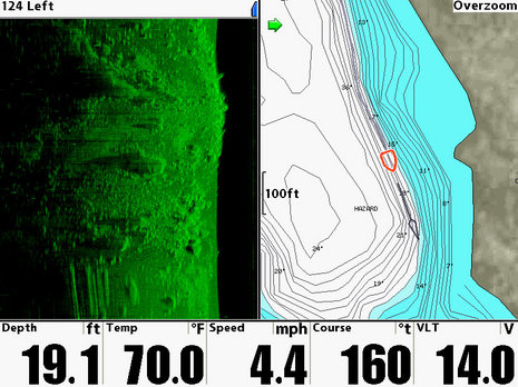
I finally got the loaner Humminbird 1197c SI installed on Li'l Gizmo, and am pretty darn impressed with its side scanning abilities. But before I get into that, check out that hi res map of my local Lake Megunticook. Yes sirree, Navionics recently updated their Premium and Platinum Hot Maps to include the data I helped collect one crazy day last fall. Frankly, the Megunticook map came out better than I expected. I know how fast the surveyors crisscrossed spots like this, and how far apart their tracks were, but I've sonared a few miles of lake bottom right alongside the new map, and have yet to encounter a serious surprise (though I'm doubting that particular 'HAZARD' warning on the screen above). Going from the old sketch chart to plotting on this level of detail is a giant leap in situational awareness (and possibly fishing success), and adding the side scan view is another big step...
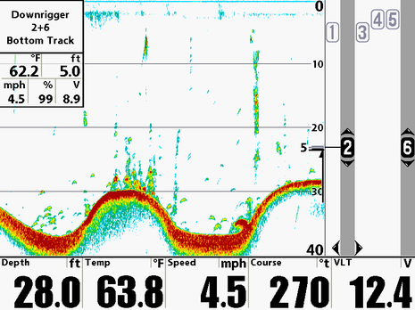
I could easily write a dozen more entries on 18" radomes, AIS, NMEA 2000, and iPhone apps, but how about something completely different? I received and bench tested a loaner Humminbird 1197c this week. My plan is to check out its side-scanning abilities, particularly now that Lowrance is challenging its dominance in this niche. But I couldn't help but notice the rather amazing downrigger controls shown in the machine's demo mode. The screen above shows one of three downrigger pairs being automatically positioned 5 feet off the bottom as my simulated boat trolls a wavy bottom. And there's much more...
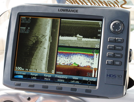
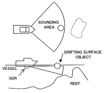
Lowrance demonstrated its new StructureScan system in Orlando yesterday, with a surprise added feature. As expected, a high-frequency, very-narrow-beam transducer collects bottom info on each side of the boat and builds an almost photographic, though somewhat distorted, image as you move along. In the picture above (click for big version), we've chosen to display only the curious structure on the left side of our track. In other words, in that left window our boat is at the top right corner and the window shows the water column and bottom extending out about 70 feet to our left and about 200 behind us. The lower right window is normal Broadband Sonar image, derived from a separate transducer, but that upper right window is something different, as is the structure being imaged...
I've long been interested in the ability of some Humminbird MFDs to side scan with near photographic precision, at least in fairly shallow and calm waters. A lot of fishermen, especially of the freshwater kind, are using the technology to find the structures where their quarry like to hang out, and you can see lots of real world results on this Yahoo group. Humminbird has virtually owned this niche for several years, and claims some patent protection, but now Lowrance is coming right at them with an HDS add-on called StructureScan. It will debut at the MAATS/iCAST show in Orlando this July (and I'll be there), but Lowrance has started showing proof of performance images...
One enterprising, if anonymous, Panbot has apparently been searching out filings at the U.S. Patent Office, and discovered some interesting recent activity regarding Furuno Electric Co. and Forward Looking Sonar (FLS). You may recall that Furuno previewed the “FL-7000” at the NMEA Conference in 2005, but then scrapped the product, purportedly due to inconsistent performance. That entry and its comments demonstrate well my personal enthusiasm for improved FLS and the current state of the technology (valuable but limited, with ongoing incremental improvements). Well, patents are hard to read, and don’t necessarily mean much, but…
Today Lowrance is announcing a new series of multifunction displays called HDS that I’m excited about seeing at the boat show (and trying when they ship in a few months). The acronym stands for High Definition System, and seems justified on several counts: all the plotter/fishfinders in the series have Lowrance Broadband Sounder technology built in; all have new and more detailed Lake Insight, Nautic Insight or at least an enhanced U.S. basemap built in, and can display every Navionics chart card, including HD Platinum Plus; and all, even the 5” combo model above, can also display Lowrance HD radar, via Ethernet. And there’s more…
That strange graphic rendered on a laptop in a car trunk stuffed with cold weather clothing represents a terrific experience I had yesterday, and a wicked lot of work. Compare the graphic—which is actually hundreds of thousands of GPS/depth data points—to Lake Megunticook. After a few months and a lot of post processing that data will become a Navionics HD HotMap available on a chart card or for use with easy-on-the-wallet HotMaps Explorer. I don’t yet know how much Navionics will let me write about their specific data collection gear and techniques (Yachting revealed a bit), but here’s what it looks like:
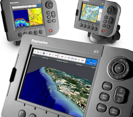
Amongst ICAST’s abundant rods and lures—even a big, lively bowl of live worms—I came across this interesting development: Raymarine previewing an impressively redesigned A-Series, previously unannounced and currently invisible on line. There will be five new models, whose names correspond to screen sizes, sort of. When the series truly debuts in October, we’ll see a 5" A50d, a 5.7" A57d, and a 6.4" A70d (hey, the C70 is actually 6.4" too), all with HD fishfinders built in (unlike the superseded models), plus A50 and A70 plotter-only versions.
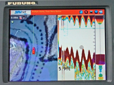
That’s a strange, but very impressive fishfinder scroll on the NavNet 3D MFD8 above, and bigger here. You see, Furuno claims that its new SC-30 satellite compass is so sensitive to a vessel’s altitude, which really only changes as it heaves up and down in seas, that NN3D can use that input to remove heave error from its fishfinder screen. I was pretty skeptical about that claim until the end of my NN3D cruise off Cape Cod, when Iker Pryzo uninstalled the SC-30 and showed us how simply pumping it up and down a couple of feet—shown below—registered immediately on the screen above. If it can respond to small, quick movements like that, it can surely detect swells and likely also compensate for pitch and roll, and thus stabilize side scanning sonar. Amazing!
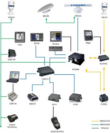
Yeeeeha…today I’m driving down to Cape Cod so that on Thursday I can ride on Furuno’s test boat equipped with the geekalicious NN3D network of gear shown above, and bigger here. Hosting the demo will be Brice Pryszo, founder of MaxSea, and his son Iker, who now works at Furuno USA headquarters. I’ll be Spot sharing, taking pictures, pushing buttons, and asking questions. And I’m open to suggestions about just what to ask and look for.