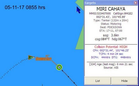
Go to this page to see a series of screen grabs illustrating a scary close call between the 32’ ketch Valhalla and the 132 meter tanker Miri Cahaya. I’d almost guess that the tanker was trying to slow down and turn right to go astern of the ketch, but that’s easy to say sitting in the comfort of my office. Captain Sargent was looking at a whole lot of moving steel with a Closest Point of Approach at one point of 44 meters! He also had prior knowledge of some malicious mariners in these waters, which is probably why he was collecting a history of screen shots. At any rate, he made a possibly controversial last minute decision to turn hard left and cross the tanker’s bow, and it worked. You might also look here to see Valhalla’s AIS setup, which includes a NASA receiver and SOB software (note above how it gives time of last message; nice!). The page also has some screens showing how AIS busy the Malacca Straits are. I understand that the Singapore Vessel Traffic Information System is possibly the busiest in the world, and is using AIS messaging heavily to route ships.
This entry is also an example of how the Internet is changing cruising (and all communications). This incident happened on 11/17, was posted to Valhalla’ssite yesterday, and Panbo reader Steve Tripp emailed me about it today. And as I was writing the entry this morning, Captain Sargent—now located in Langkawi, Malaysia—updated this useful page of cruising info about Port Carmen, Philippines, including an antique chart scan improved with GPS annotations by Steve. Big planet, small world.
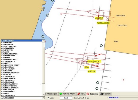
The above snip from a Nobeltec VNS screen (full size here) shows how some of the megayachts tied stern-to at the Ft. Lauderdale show looked AIS-wise. There are obviously a few errors either in the vessel dimensions or GPS locations (the red “X”s) or the underlying chart, but mind you this is a very zoomed-in view. I saw lots of boaters looking at screens like this and realizing what AIS can do for them. I also got to go aboard several of the megayachts and can tell you that the crews on those boats are also impressed with the technology. The Nobeltec exhibitors were using the Nasa/Si-Tex receiver with a regular VHF antenna tied to the top of their booth inside a giant steel framed tent, and were still getting some 30–40 targets within about a ten mile radius. The Si-Tex ColorMax plotter shown below was similarly set up and getting lots of targets.
The show, by the way, was better attended by exhibitors and customers than I had guessed, and I’m glad I went. More to come.
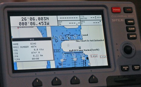
What's wrong with this AIS target, seen off Naples, Florida, a couple of weeks ago (with the Si-Tex receiver)? How about a bogus MMSI # (only 4 digits), no name, and destination as “HOME” (cute!) for starters. Plus the distances fore, aft, port, and starboard from the transponder’s GPS had been input as 10, 20, 30, and 40 feet (cute again, but impossible). That’s why Coastal Explorer—which, like many good AIS plotters, can properly size a target when zoomed in—drew the odd target icon above. But here’s the thing: even though someone had obviously done a half-assed installation of this transponder, it still plotted very smoothly down the coast, even though it was doing 25+ knots and I was only listening on one frequency with a crappy antenna. In fact I was able to get a visual on it when it went by the hotel and would guess it to be about a 32’ Tiara or something of the sort. How and why it had a $5,000+ Class A transponder on board I have no idea (megayacht tender?).
My notes on Class B AIS have prompted some interesting comments here and privately, so some more entries will be coming. But, for those of you less interested in AIS, be assured that I have lots of new product info in hand, and am testing some gadgets and software I haven’t even mentioned yet. Have a wonderful weekend.
Today, I’m afraid, we must speak of “frequency agility.” Part of the Class A standard is that transponders must be able to change channels if ordered to by the presiding local coastal authority. The digital command is received on the VHF DSC calling channel, 70. As mentioned in the past only one port is currently using this function, Tokyo, and I’ve heard that even it may turn back to regular channels 87B and 88B. Nonetheless, in September the U.S. apparently surprised international AIS committees by demanding frequency agility in the Class B standard. (This may have something to do with the still unsettled dispute with Maritel over use of 87B in the States, but, again, another story). At any rate, this change will mean that Class B transponders are more complicated and more expensive than originally conceived, and slower to arrive. Actual transponders available by the end of 2006 for around $2,000 is now sounding realistic. It’s also possible that there will be non-agile Class B transponders that are not approved for use in the U.S.
Now, as promised, let’s noodle a bit about what the Class B standard will mean. My thoughts:
• Some bigger yachts are going to opt for Class A—perfectly legal for anyone to carry—because they’ll decide that the additional power and priority, plus things like ship-to-ship messaging (not in Class B), are worth the added expense and install hassle.
• I’m wondering if a single frequency receiver will be effective, especially in close quarters, when it’s only getting dynamic data every minute at best. Real time tracking starts to get unreal, but maybe not enough to make a difference.
• Overall, Class B is going to greatly enhance AIS. Isn’t there a famous computer postulate that puts the value of a network equal to the square of its users? Isn’t AIS a more-the-merrier—and safer—situation, even for the lurkers (receive only).
PS. For more details of Class B, check out this page at Y-Tronic, noting that the Class B standard is supposedly going to use “Carrier Sense”, not “SOTDMA”.
Finally I have some specifics about the Class B AIS transponder standard, which is “very close” to finalization:
• Like Class A, static data will be broadcast every 6 minutes on alternating channels. A few fields, like destination, are missing but MMSI, boat name, call sign, ship and cargo types, ship dimensions, and GPS antenna position will all be sent.
• Unlike Class A, dynamic data will only be broadcast every 30 seconds (if the vessel is going over 2 knots, 3 minutes if slower). Again some items, like rate of turn, are absent, but MMSI, position, COG, SOG, and heading (optional) go out.
• Transponder power is limited to 2 watts, whereas the Class A max is 12.5 watts, plus Class B transmissions are ‘polite’. That’s actually a technical term meaning that the Class B time-sharing protocol (different from A’s, but that’s another story) will not slow down Class A in busy waters.
• Class B transponders are required to have an internal GPS, which will simplify installation as thus the only hookups are power, the optional heading sensor, and data out to AIS plotting devices. The 18” SeaLinks SL162B, shown, is an interesting (antennas included!) example of what the transponders will look like. I’m told that several other manufacturers are raring to go.
But there has been a recent change to the Standard that may slow down the Class B roll out and make the transponders more expensive, at least in the U.S. I’ll talk about that tomorrow, along with some noodling about what the above specs mean for single channel receivers. Your input is welcome, of course.
PS A big thanks to Fred Pot and Lee Luft, an analyst at the USCG R&D center (and an important figure in the development of NMEA 2000), for educating me about Class B. It’s odd that the comfy resort we shared breakfast in week before last is now closed due to Wilma. The latest on the Ft. Lauderdale show, by the way, is postponement to Thursday, Nov. 3, putting my Monday morning prediction almost on the money.
It turns out that Nobeltec has decided to market the Si-Tex (Nasa) single frequency black box “AIS100” receiver instead of the Comar SLR-100 as I had first presumed. I dare say that this move, along with adding AIS tracking to the VNS program, is meant to make AIS available at modest cost. Nobeltec is selling the AIS100 for $330 (plus you’ll need a VHF antenna). I very much like the idea of encouraging recreational boaters to see what AIS tracking can do for them, but am still a little leery about single frequency receivers and the quality of the Nasa box in particular. Many electronics manufacturers are testing these receivers and some report that the Nasa box is none too sensitive, dropping further away targets when compared to say a $1,000 SeaLinks RadarPlus (using the same antenna). Then again, other testers say that all the receivers are fairly comparable, and one notes that the placement and quality of the antenna is an important factor. I’m wondering how effective single frequency listening will be when Class B transponders hit the market. I’ll write soon about the what and when of Class B, but do know that under that standard boats will transmit dynamic data—MMSI, position, COG, SOG, etc.—every 30 seconds at best (Class A transponders put the data out every 2–10 seconds based on speed and rate of turn).
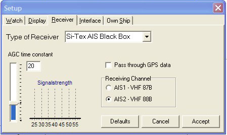
Another thing about the Si-Tex/Nasa/Nobeltec receiver is that it sticks to one frequency unless you tell it differently. I’m not sure how important this is but have not seen a way to actually manage the box except in the standard edition of Yacht AIS, seen above, which also has a control for Automatic Gain Constant and a signal meter. The impression I’m getting is that any AIS, even half listening to half a transponder, is a good thing, but the receiver market is going to have several tiers, and to some degree you’re going to get what you pay for.
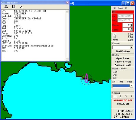
I felt like a spy in an old WWII movie, rigging a VHF antenna and GPS on the patio outside my hotel room late at night, then hunching over my laptop hoping for certain transmissions…but, by golly, it worked. The Si-Tex/Nasa receiver heard an AIS equipped 37m vessel called Ixplorer apparently anchored or docked 3.7 miles away in La Ciotat. There was only that one target (the Radio Shack antenna was missing a set screw, which probably affected range), plus I didn’t have a detailed electronic chart of the area, but it worked. That’s the target info showing above in SeaClearII, the freeware that comes with the receiver. SeaClear was pretty easy to set up with both USB GPS and AIS serial input. I also tried the gear with Coastal Explorer 1.1, again easy to set up, but also capable of calculating CPA/TCPA (and displaying more target info, and in a couple of different ways). I’ll try the rig some more when I’m in Naples tomorrow and later in Ft. Lauderdale, assuming my luggage gets there.
PS. Totally different subject, but was somewhat saddened to learn on Zephyr that Pride of Baltimore II (a remarkable boat I’ve had the pleasure of twice passaging aboard) lost her entire rig off France last month. The good news, and hard to imagine how, is that no one was hurt. More good news, for those interested, is that two crew members are blogging the mishap and repairs.
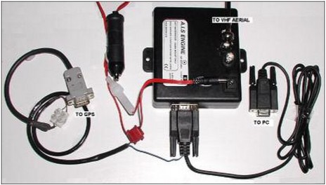
Well, I’m beginning to understand why the Nasa AIS receiver is so much less expensive than most others on the market (besides the single frequency business). For one thing, the wire connections to the “not waterproof” box are funky compared to most marine electronics. Above you can see how an install might look if you use its ability to blend a GPS into its data stream. Note how the red power wire uses a pin connector with no lock (if your boat is rattlely, you might want to duct tape it). The illustration, by the way, is from an installation pdf that Digiboat put together, which is way better than what came with the unit.
Then there’s the fact that once you’ve wired the receiver to antenna, PC, and power, you have no way to know if it works. No LEDs, no NMEA strings unless it’s actually receiving targets. Without a real manual, I had no way of knowing what was going on so I e-mailed customer support at Digiboat, who seem to know this hardware, and got a prompt response that confirmed my fears, “the NASA AIS Receiver gives NO INDICATION whether it's working, or not - quite frustrating really. Unless, of course, you're surrounded by transmitting targets.”
In fact, Simon Blundell from Digiboat has figured out a way to solder 4 useful status LEDs into the Nasa receiver, and has posted a thorough Web page about the project (check it out…this is DIY pioneering!). He also pointed out that I could check the install by doing the GPS bypass above. Nah…I will be in hotel right on the Mediterranean coast near Marseille, France, later this week, so hope to test with real targets. Blundell suggests that once I see how well the Nasa box works for the money, the negatives will fade. We’ll see.
The animation above shows how AIS system data can be used to predict a vessel’s future track, even “bottom sweep”—in this case 2 minutes ahead of its actual position, speed, rate of turn, etc. It’s from AECDIS2000, a commercial grade PC software product developed by a Swedish company called Adveto, which has a long history with AIS. (Check out the interesting illustrations about how radar can misinterpret a target’s turn direction on Adveto’s AIS page). This software was pointed out to me by Fred Pot, who seems to be aware of numerous other AIS possibilites that most of us haven’t heard of yet. For instance, did you know that the system allows vessel traffic service (VTS) operations to transmit “ghost” AIS targets? In other words they can use ARPA radar to track a vessel that’s not AIS equipped—plus perhaps get its name, destination, etc. by VHF—and then send out AIS messages that let other boats in the vicinity “see” it. By the same token, some nations are apparently considering “virtual bouys” as a cost saving move. Instead of all that heavy hardware, an antenna ashore will simply broadcast an AIS message marking the position of the old entrance bouy. On the other hand, some are calling for actual bouys that transmit real time current and weather data. For example, there are critical passes along the inside passage to Alaska where even cruise ships have to wait for near slack current, but the actual time of slack can vary somewhat from the predictions. We’re just beginning to understand where AIS technology will lead.
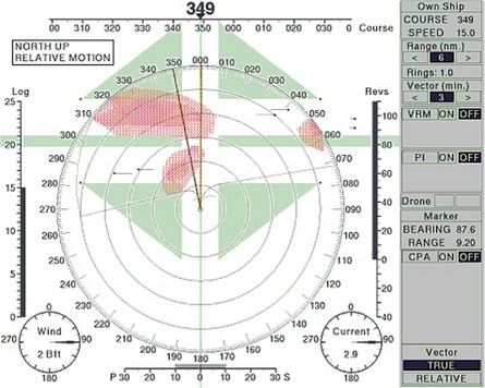
Fred Pot showed me a really interesting new concept in target plotting that was developed at a Dutch maritime school. Currently many plotters/PCs and radars can automatically use ARPA and/or AIS info to calculate the CPA (Closest Point of Approach) and TCPA (Time of CPA) for vessels within range. Typically they flash a warning if a potential CPA drops below a preset threshold like 1 mile, meaning that you and the other vessel are going to pass that close if you both maintain current course and speed. This is all good—and beats the hell out of manual plotting—but still leaves the operator to figure out how to change course/speed to avoid tight CPAs, which can get especially complicated when there are multiple vessels involved. “Safe Pass” works a little like computerized weather routing, calculating various CPA/TCPA data versus possible changes in your course and then plotting potential safe, and dangerous, areas ahead. In the example above, bigger here, you are about to cross a shipping lane with two vessels crossing each way. Turning left will make things worse, but turning right between the red “danger clouds” will result in a safe passage (assuming the other vessels maintain course and speed). The concept seems to make a lot of sense, and has purportedly tested well in ship simulators (at that Dutch school), but so far no developer is yet working to make it available. I wonder why not?