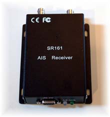
* Panbo reader Gary has a positive report on the Smart Radio SR161 sold by Milltech Marine. Using it with a standard VHF antenna on his 53’ mast, he’s seeing (in CE) ”marine traffic as far away as Port Townsend, which is a fairly straight shot 30 miles north. I could see traffic in Seattle’s harbor, which is only 4 or 5 miles away, but there is a large hill between it and Shilshole. A few ships showed up in Tacoma, 25 miles or so south, but not as clearly – they were blue triangles without names. There are a lot of twists, turns and hills between my location and Tacoma.” He had some problems with a another setup at home, since resolved, but “In all, it is pretty amazing to get all this info from a $200 black box!…It will be a great addition to the GPS, radar, and charting software to use while crossing the Straits of Juan de Fuca in the fog. Now I will know the size, speed, course, and even name of those large dots coming at me.” A guy named Paul is also posting reports on the SR161 at rec.boats.electronics.
* Another Panboid, Jeff, found this low cost dual frequency receiver from a German company called EasyAIS. If you hit the ‘products’ tab at the site you’ll see that they also have an interesting splitter that will supposedly let you share AIS, VHF, and FM on one antenna. Has anyone had experience with EasyAIS gear specifically, and with antenna splitting AIS in general?
* Then there’s the recent plan in the U.K. to built a national infrastructure of AIS listeners, because “AIS technology will form a key building block in an 'e-navigation' system of the future - an internationally integrated, electronic navigational aid that could transform the shipping industry and provide a safer and cleaner marine environment across the world.” Wow…e-navigation.
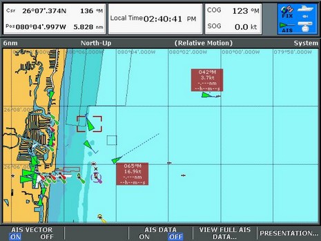
Whereas some of you greedy tech heads saw the world’s first VHF/chart plotter and wanted it to be an AIS transponder too, Standard Horizon wants you to know that the CPV350 can at least display AIS targets when hooked up to a receiver, as illustrated by the menus above. In fact, Standard says they have the technology to include an AIS receiver inside the CPV, but wanted to keep the cost down. Last week I also noted how Raymarine demoed its new AIS abilities in Miami, which I think will really help to make boaters aware of the technology. I didn’t get a good picture, but here’s a screen shot (bigger here ).
* Rich Ray sent in a very interesting article at Lectronic Latitude which suggests that Class B AIS transponders will be made mandatory for recreational boats over 34’. I am quite dubious about this, though the article seems well reported. It is true that the U.S. Dept. of Homeland Security sees AIS transponders as a valuable surveillance tool (ID all the good guy radar/AIS targets, and the bad guys are left exposed), but my sources in the Coast Guard say that the strategy is to encourage transponders on smaller non commercial vessels, not mandate them. I believe the USCG has even distributed grant money toward development of inexpensive transponders.
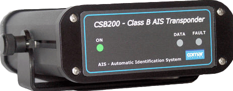
* Meanwhile, the U.K. company Comar has quietly introduced the CSB200, above, which is expected to retail for $1,200. But it’s not shipping yet: “We initially anticipated shipping early orders in March/April; however due to delays in obtaining type approvals this has now been extended to August, for Europe. Once we have obtained approvals in Europe we will then submit for FCC approvals, so realistically product availability in US is probably late fall.”
* And a new outfit, Milltech Marine, has started selling Smart Radio single and dual channel AIS receivers. The single is even less expensive than the Nasa AIS Engine, but looks to be better made (it has LEDs!). A Panbo reader just ordered one, and promises to report back.
* Speaking of Nasa, the folks there are confusing consumers by claiming that their AIS output is NMEA 2000. That’s just not true. I wrote Nasa about this and they say they mean just the 38400 baud speed. But that doesn’t make sense either; NMEA 2000 is faster than that. Knuckleheads!
* Finally, AIS targets were all over the Miami Boat Show, but probably the biggest single boost for the technology was Raymarine showing a lot of writers and marine electronics dealers how it works out on the water, on E and C Series displays.
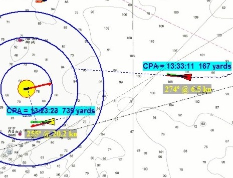
That yellow vessel with the bold range rings is Capt. me off Boston a couple of days ago, or at least a simulated Capt. me. But the AIS targets were real! That’s because at least this beta version of The Capn lets you get AIS targets off the Internet, in fact comes set up (see below) to get all the receivers being streamed by SeaLinks (which includes Penobscot Bay, my home waters). The feature is not something you’d use at sea, but it sure is useful for seeing how an ECS handles AIS targets. For instance, I really like the way the Capn plots the actual CPA; for the target ahead it’s that little (167 yard) dotted under the the 2nd range ring. It helped me understand better what the pass was going to look like, and being prudent, I decided to turn another 20° right.
Notice, by the way, how The Capn lets you turn off anchored and docked targets. It makes sense but watch out. When I checked out Penobscot Bay this afternoon, the towboat Penn #4 was doing 8 knots off Monhegan but broadcasting “At anchor”, while Penobscot, doing .01 knots at a pier in Rockland, was labeled “Underway under power”. Garbage in, garbage out!
My head hurts! I’ve got 11 ECS packages installed here now, and I’ve been fooling with them on two computers for the last several days. Would you be surprised to hear that Windows XP has occasionally crashed, sometimes violently, and not everything plays together nicely? Like when I start Nobeltec Admiral 8.1, MaxSea 12.2 also tries to start! I have the two computers connected with a null serial cable, meaning I can run NemaTalker (a great utility from SailSoft) on either one and an ECS running on the other thinks it hears, say, the virtual GPS above, which I control, plus a sounder, compass, etc.. In other words, I can ‘drive’ the boat on one screen, and plot the results on another. It’s geek fun for sure and a better way to test an ECS than with its built-in simulator/DR function. Unfortunately NemaTalker (full screen here) does not send AIS targets, and there aren’t many where I live, but one ECS provides its own test AIS in a very interesting way, explained tomorrow.
It makes more sense than you might think! That’s because so few plotters can yet display AIS targets, and a PC that can is often down below, too far from the helm for effective target tracking. Memory Map's PocketAIS will give a user audible collision danger alerts and/or sorted tables based on CPA or TCPA, as well as color coded target icons…all the normal AIS safety tools. And it could conceivably do all this wirelessly, as developer Richard Stephens often uses his creation, except that the nifty Bluetooth enabled NMEA mulplexers don’t yet do AIS speed (ShipModul is reportedly working on it).
Meanwhile Panbo friend Terry Sargent has been sailing around Malaysia some more, and has once again documented an interesting AIS encounter, this time while using MaxSea and Yacht-AIS software.
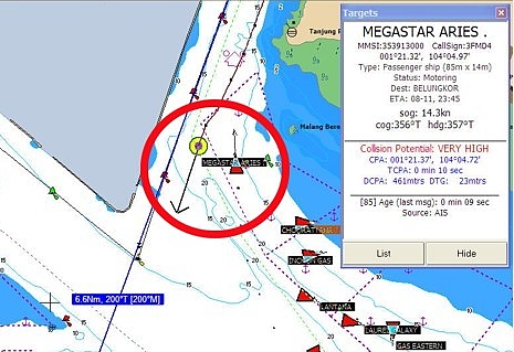
It’s great that Terry Sargent has joined our discussion about the AIS-documented near miss he had in the Malacca Straits. I really admire his desire to thoroughly debrief his experience, and his willingness to share it with the rest of us. Terry has also expanded his web page about the AIS hardware and software he’s using. Above is a clip from a screen shot he took while transiting the Singapore Straits, with the red circle added to highlight Valhalla and the nearby passenger ship Megastar. He notes that his SOB freeware is calling the collision potential “VERY HIGH” even though he and the ship are almost beam-to-beam during a standard port-to-port pass. That just means that the logic behind SOB’s warning is imperfect. Note also that SOB’s AIS data window is unusual in that it lists CPA as a position with a separate DCPA to give the distance between vessels during the CPA and also DTG for the distance to go (until you arrive at the CPA). Calculating just CPA (as distance) and TCPA is the norm. SOB is trying to give as much information as possible, which is admirable, and I’m sure a user would get used to its style. By the way, here are some more AIS screenshots—this time using Nobeltec on the North Sea—posted by a Kees Verruijt on his Scanner 391 site.
Whereas so many of you are interested in AIS, and so many news bits keep coming in, I’m starting a “this and that” series…
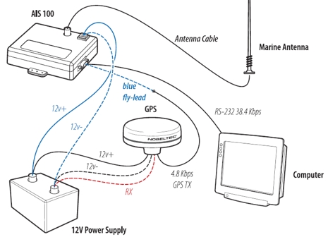
* Nobeltec has put up the best looking AIS 100 manual to date. Above is a wiring illustration, including how to pass GPS data through the AIS 100, though Nobeltec does not recommend doing so. (For them it’s largely an issue of technical support, but I also understand that the AIS 100 only passes through the GPRMC data string, which may mean that you won’t be able to see, say, how many satellites a GPS is receiving. Anyone know for sure? {The answer is yes, confirmed by GPSNavX in comments})
* Meanwhile, NASA has apparently changed the firmware in the AIS 100 so that it now automatically switches channels every 36 seconds, which seems like a good idea. Supposedly it is possible to update older units, but I don’t know how, or where you can get the update (yet).
* Navicon, a Danish company doing a lot of AIS software development, has introduced a Java-based charting program called AIS Navigator.
* True Heading, a Swedish AIS company, has developed a splitter for sharing a single antenna with an AIS receiver and a regular VHF radio. Look in Products/Accessories. They also have a new product called Blue-Pilot which uses Bluetooth to make a Class A transponder’s “pilot port” wireless. Better yet, it is supposedly able to find and correct problems in the plug installation (which are said to be common). Look in Products/AIS, where you’ll also see the Smart Radio 161 single channel receiver recommended for shore use only.
Wasn’t I just noodling about celestial mechanics? Well it turns out that for the first time since 1998, the time authorities need to insert a second into the world clock “to make up for the slowing down of the Earth’s rotation”. They’re going to do it at midnight GMT, December 31, and it’s going to affect AIS transponders because atomic time from the GPS system is critical to the signal sharing protocol. ACR warns that all transponders need to be re-synchronized on Jan. 1 or "the GPS signal received by the transponder could fail to identify targets on the AIS display.”
PS There’s more on leap seconds here, including my new favorite obscure department name: The Sub-bureau for Rapid Service and Predictions of Earth Orientation Parameters of the International Earth Rotation Service, located at the U.S. Naval Observatory.
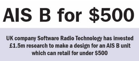
So goes the headline in the Nov. issue of Digital Ship (click on link in “Navigation” section, and thanks, Raye), but there’s something odd about this otherwise very intriguing proposition. For one thing, SRT’s business development manager doesn’t seem to think that Class B transponders will make boating safer:
“Using Class B as an anti-collision device does not make a large amount of sense, he points out - ship owners can see if they are about to hit something much easier by using their eyes than by trying to make sense of a screen with 1,000 vessels on it. ‘The vessels will look like snow on the screen,’ he says. ‘Its not going to have any practical use.’”
Perhaps I’m just in a skeptical mood, but I wasn’t surprised to learn at SRT’s site that’s it’s just become a publicly traded company.

 which is a fairly straight shot 30 miles north. I could see traffic in Seattle’s harbor, which is only 4 or 5 miles away, but there is a large hill between it and Shilshole. A few ships showed up in Tacoma, 25 miles or so south, but not as clearly – they were blue triangles without names. There are a lot of twists, turns and hills between my location and Tacoma.” He had some problems with a another setup at home, since resolved, but “In all, it is pretty amazing to get all this info from a $200 black box!…It will be a great addition to the GPS, radar, and charting software to use while crossing the Straits of Juan de Fuca in the fog. Now I will know the size, speed, course, and even name of those large dots coming at me.” A guy named Paul is also posting reports on the SR161 at rec.boats.electronics.
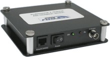 * Another Panboid, Jeff, found this low cost dual frequency receiver from a German company called EasyAIS. If you hit the ‘products’ tab at the site you’ll see that they also have an interesting splitter that will supposedly let you share AIS, VHF, and FM on one antenna. Has anyone had experience with EasyAIS gear specifically, and with antenna splitting AIS in general?
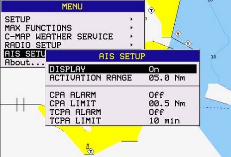
 My head hurts! I’ve got 11 ECS packages installed here now, and I’ve been fooling with them on two computers for the last several days. Would you be surprised to hear that Windows XP has occasionally crashed, sometimes violently, and not everything plays together nicely? Like when I start Nobeltec Admiral 8.1, MaxSea 12.2 also tries to start! I have the two computers connected with a null serial cable, meaning I can run
  It makes more sense than you might think! That’s because so few plotters can yet display AIS targets, and a PC that can is often down below, too far from the helm for effective target tracking. Memory Map's