MFD and AIS anomalies, be careful out there
Consider this is a portrait of a deeply experienced boat guy who still remains skeptical about the wonders of modern marine electronics. Lord knows I tried, but gremlins sabotaged my efforts from the moment when my old friend Joe McCarty arrived in Rockland, Maine, for the trip to Baltimore. I was using the Garmin Helm app on my iPad mini to watch the tank gauge as I squatted on the deck pumping diesel fuel and Joe just had time enough to say, "Well, that is cool!" when the digitized tank reading plunged from 85% to 20% and stayed stuck there even as we topped off using the old-fashioned method of listening to the changing vent gurgles...
Though expressed electronically, the tank problem was actually a mechanical one, and the floating sender that had apparently been jammed down by the high volume diesel fill freed itself at some point that night, probably when Gizmo whacked a particularly sharp wave. But during the following ten days and 741 miles, we experienced several pure and truly peculiar electronics anomalies.
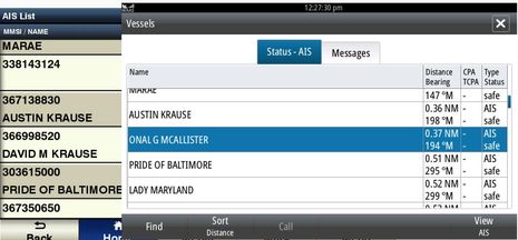
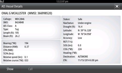
We learned, for instance, that the two Simrad NSS evo2 displays can sometimes confidently misidentify AIS targets. I didn't get any images of the problem underway, but was able to find a good example here in Baltimore Harbor. The Garmin 741xs and Simrad NSS7 evo2 screens above both show lists of AIS targets sorted by distance and thus, the lists are essentially the same. Except that David M Krause is the real name of the tug tied up next to the Austin Krause across the harbor and "Onal G. McAllister" is definitely not!
If you compare the NSS7 details of the "Onal G McAllister" with the Marine Traffic David M Krause listing you'll see that the MMSI, Callsign, etc. above are for the Krause, just like every other AIS display on Gizmo was reporting. And further sleuthing revealed that there is a Baltimore tug listed as the Donal G McAllister with entirely different details except that its Destination is "BALTIMORE" not "ALTIMORE"...
And it turns out that the anomaly is repeatable, sort of. I've rebooted all the systems three times now, and while the NSS evo2 MFDs seem to display some fifty AIS targets fine, they always misidentify the David M Krause, using the name and destination of some other current target with the first letter dropped off. Right now the still tied-up D Krause is listed as the "Aple Hill" with the Destination "S Bal" while the real Maple Hill (destination "US Bal") is underway 4 miles away. Obviously this strange glitch could lead to some confused boat-to-boat communications.
Incidentally, the NSS displays are getting AIS over NMEA 2000 from the Simrad RS35 VHF I'm testing, while the Garmin and other systems are getting it over a separate N2K network from the Vesper XB8000 AIS transponder also being tested. So maybe the RS35 is the problem here, but darned if it doesn't display the David M Krause perfectly well on its display and wireless handset. I could switch AIS feeds to further troubleshoot this issue, but maybe Simrad is already fixing it and besides, I have bigger anomalies to deal with...
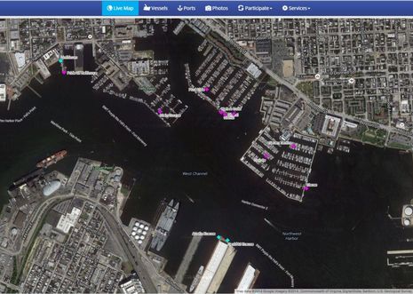
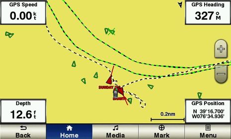
For instance, the two Garmin MFDs being tested both lost all their built-in charts! The screen above is the best view the 741xs can show of Gizmo at that same (wonderful) Anchorage Marina slip seen on the Marine Traffic screen. I can live with the fact that Garmin (and other manufacturers) insist on tagging nearby AIS targets as dangerous, even though we're all tied up on the same dock and I've turned AIS alarming to the absolute minimum, but losing the charts would be a serious problem if I didn't have other chartplotters at hand. However, it is possibly the strangest MFD update issue I've ever encountered, and I believe Garmin's claim that they've never seen it before either...
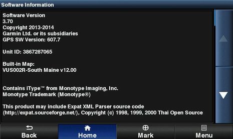
The problem obviously started when I updated the Garmin 741 and 8212 MFDs in early September, though I had no clue. The update was at least a month old -- a strong indication that it hadn't caused problems on other boats -- and everything seemed to run fine until Joe and I found ourselves motoring off the charts halfway across the Gulf of Maine in the middle of the night. When I did the updates, an old G2 Vision card for Southern Maine was in one of the 741's slots and we were using those charts over the Garmin network until we left the region, so only then did we realize that the MFDs had perversely decided that their built-in charts are that same South Maine v12 region, as seen above.
And aren't they stubborn about it. I still don't know if the vast portfolios of U.S. and Bahamas charts that came built into both machines are still there, but I do know that Factory Resets and reapplied software updates, old and new, didn't make them accessible. The Garmin engineering team want to swap the MFDs out so they can investigate the problem, but I asked to try a less aggressive fix first. However, the US Marine Detail Update they sent won't work on these machines, which stubbornly reply, "This update is not compatible with the built-in chart." So, holy cow, it appears that a weird update glitch can wipe out all the built-in charts on an MFD network, which can only be fixed with a hardware swap. It may have only happened to me (and who better?), but if the latest hardware and software from Garmin can do this even once, I'd guess that any of the modern highly complex MFD systems are capable of very strange behavior, particularly after an update.
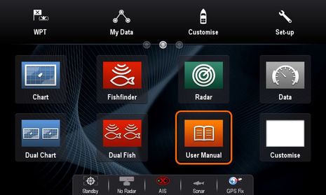
The Raymarine system that's part of the glass bridge testing program wasn't trouble-free either, though I failed to capture good illustrations. I updated this system, too, and we were happy to use the new auto routing available with Navionics chart cards (to be discussed in detail, and hopefully compared to Garmin auto routing, eventually). But somehow the IR and regular camera apps got mixed up. I accept some responsibility, as I switched the video inputs on the gS125 at some point, but it got so I didn't know whether I'd get the FLIR thermal cam (very helpful during the delivery) or the Ray100 rearview cam when I invoked either app. The fix was to rebuild every favorite page that had either app window in it, but then I found that some of those favorite page icons vanished from the networked a77 (which doesn't have an analog video input and doesn't support the IR app). The a77 had a home page with holes in it that couldn't be filled with the normal Customize/Homescreen/Edit Pages command. I thought I'd captured the odd homescreen before I did the reset that's shown above and which wiped out all the existing favorite screens I'd created.
Toward the end of the delivery, the Raymarine ethernet networking started acting up. One morning the flybridge keypad wouldn't work while the next morning (or reboot) it would work fine, but the radar wouldn't come up or the two MFDs wouldn't share charts. Now this could definitely be more of a yours-truly install issue than a Raymarine glitch, but that didn't matter to Joe, who by this time would begin his watch with the taunt, "So what's working today, Benny?"
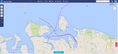
He wasn't the only one. I also got emails wondering why Gizmo seemed to motoring backwards on Marine Traffic. When I first tried the Vesper XB8000 AIS transponder on the water, I reported a reversed boat icon heading problem seen in Coastal Explorer using the Vesper's USB data output. It was an especially odd problem because the Vesper was also outputting the correct heading it was receiving from the N2K network and I fixed the icon issue in CE by giving Heading Sensor a higher priority than AIS Heading (thanks to CE tech support). To my knowledge no other vessel has seen Gizmo's AIS target backward and I never saw that on Marine Traffic until this trip. But I took that screenshot above as we headed west toward New York City on 9/11, after visiting Lloyd, Huntington, and Northport harbors going backwards as tracked on MT! Gizmo's MT track looks OK now, though that too is mysterious as I haven't changed anything about the Vesper install.
Meanwhile, the trip also confirmed that the Vesper XB8000 -- wonderful as it is at distributing AIS and other data via NMEA 2000, USB and WiFi -- is not good about joining an N2K network when it's been on for a while and suddenly the 2000 network comes alive. I saw a bit of this in that earlier lab testing -- plus a definite incompatibility with the Garmin network that was fixed in a Garmin update -- but we found we had to reboot the Vesper at least half the time we started up the nav systems or the Garmin, Raymarine, and Furuno gear on the same network wouldn't know it was there. Vesper has a software update available and I guess I should try it.
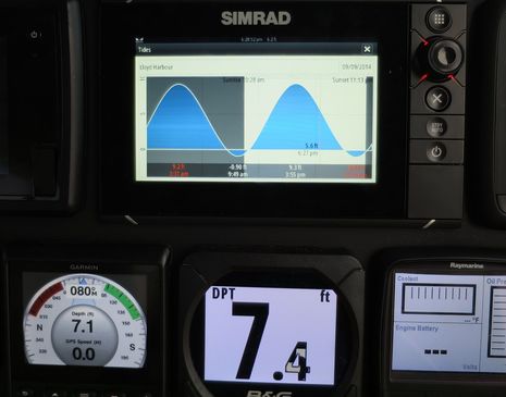
I have one last anomaly, and it took place as we entered Lloyd Harbor just before dark after blasting down Long Island Sound (fuel efficiently). We knew that half that harbor is too shallow for Gizmo to anchor and the Simrad NSS evo2 had told us that there was almost 6 more feet of tide to fall. So we were pretty confused when we quickly found ourselves in about 7 feet and I wouldn't have dropped the hook except that we were right behind a large vessel on a mooring. It was only at rest that we noticed how whacky the NSS sunrise and sunset time predictions were (even though the current time was correctly shown) and used another tide source to confirm that it was dead low. Beers were enjoyed, and I'm pleased to add that I have not been able to duplicate that NSS tide prediction problem since. Apparently it was a fleeting anomaly.
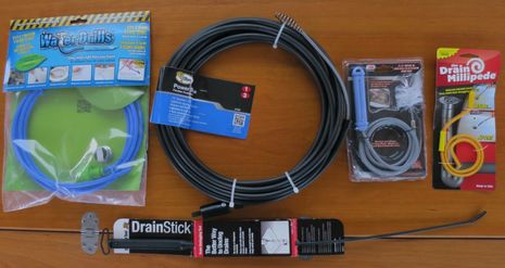
I want to conclude with the fact that I've never seen so many significant electronics issues reveal themselves at once and that Gizmo is a highly unusual boat with so many new systems on board. Plus some of the problems may be my fault in ways I don't understand yet, which I'll be happy to acknowledge if enlightened. And finally there's the fact that none of these issues caused us any real trouble. That role was taken by Gizmo's Lavac toilet, which failed in a way that required a horrendous rebuild. Joe and I have sworn never to reveal the details but it did further confirm my longtime believe that he's is a master of boat systems. Which is one good reason you might want to charter the fast and handsome Allied 42-foot yawl Furly B that Joe completely rebuilt and maintains. It even has a nice Garmin electronics systems, though it may be updated to the latest software version. The spectacular head failure is also why I immediately purchased five different snake/unclog tools, though I only plan to test them if I have to.


 Share
Share
How do you have a Lavac toilet require a rebuild? I thought all you would do is swap out the pump and move on. The other possible failure point would be the gasket. I'm curious because the Lavac is the front runner to replace my skipper head, which, while wonderful, is expensive and hard to fix when defeated.